METAR & TAF KSWO
Current METAR
Observed 17:53Z
KSWO 271753Z 23009G19KT 10SM CLR 38/19 A2987 RMK AO2 SLP096 T03830189 10383 20250 58010
- Wind
- 230° @ 9G19 kt
- Visibility
- 10 SM
- Temp / Dew
- 38°C / 19°C
- Altimeter
- 29.87 inHg
- Clouds
- CLR
- Density alt
- 4,062 ft
- Ceiling
- Unlimited
- Rules
- VFR
Airport info & contacts
Manager on record, flight service, ARTCC, attendance schedule and pattern altitude — published by the FAA and refreshed every 28 days.
Location
- From city
- 3 NM NW
- VFR sectional
- WICHITA
- Pattern altitude
- 800 ft AGL · 1,800 ft MSL
- ARTCC
- ZKC · KANSAS CITY
- NOTAM facility
- SWO (NOTAM-D)
Airport manager
- Name
- KELLIE REED
- Phone
- 405-533-8425
- Address
- 3304 N AIRPORT INDUSTRIAL ACCESS RD, STILLWATER OK 74075
Flight service · Hours
- FSS MLC
- MC ALESTER1-800-WX-BRIEF
- Attendance
- 0800-2200
Frequencies
Tap any row to copy the frequency to your clipboard.
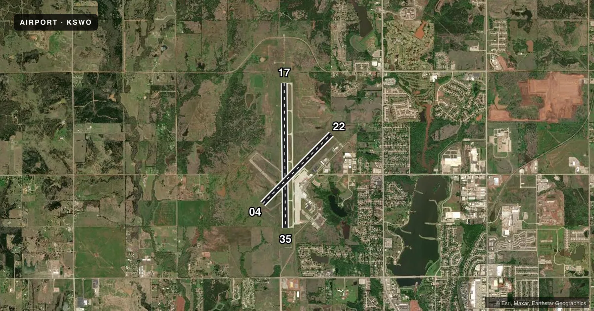
Runways & pattern
Full pagePattern entry · RWY 22
LEFT TRAFFIC| Runway | Heading (°M) | Length | Surface | Traffic |
|---|---|---|---|---|
| 17/35 | 174° / 354° | 7,401 ft | CONC | Standard L |
| 04/22Favored | 40° / 220° | 5,002 ft | ASPH | Standard L |
Runway end performance
| End | TORA | TODA | ASDA | LDA | VGSI | Approach lights | Obstruction |
|---|---|---|---|---|---|---|---|
| 17 | 7,401' | 7,401' | 7,401' | 7,401' | PAPI 4-box left(3°) | MALSR | — |
| 35 | 7,401' | 7,401' | 7,401' | 7,401' | PAPI 4-box left(3°) | — | — |
| 04 | 5,002' | 5,002' | 5,002' | 5,002' | PAPI 4-box left(3°) | — | 3', gnd, 520' from thr, 0' R of cntrln, slope 45 |
| 22 | 5,002' | 5,002' | 5,002' | 5,002' | PAPI 4-box left(3°) | — | — |
Declared distances in feet. TORA = takeoff run available, TODA = takeoff distance, ASDA = accelerate-stop, LDA = landing distance.
Airport sketch
Runways drawn to scale from FAA survey coordinates, rendered over satellite imagery. Not for navigation.
Approaches & charts
ILS · 1
Services on the field
Fuel grades, oxygen, maintenance, ramp storage and lighting — as declared to the FAA by the airport operator.
Fuel & services
- Fuel
- 100LLA
- Airframe repair
- Major
- Power plant repair
- Major
- Other services
- AFRT,INSTR,RNTL,SALES
Ramp & ground
- Transient storage
- Tie-down
- Hangar
- Landing fee
- No fee published
- Customs
- Not available
- Lighting schedule
- SEE RMK
- Beacon schedule
- SS-SR
- Beacon
- White / Green (civil land)(WG)
- Wind indicator
- Lighted
- Segmented circle
- No
Fuel & FBOs
Cheapest 100LL and Jet A on the field and nearby. Always confirm with the FBO before taxi.
Airport notes
Surface conditions, obstructions, local procedures, lighting outages and other notes published with each FAA cycle.
General notes
- ARFF INDEX B MAINTAINED; ARFF INDEX C PPR.
- PTN OF TWY F NORTH OF T-HNGR 2 NOT VSBL FROM ATCT.
- FOR CD IF UNA TO CTC ON FSS FREQ, CTC KANSAS CITY ARTCC AT 913-254-8508.
- STUDENT OPS & BIRDS ON & INVOF ARPT.
- ALL RAMPS UNCONTROLLED.
- AFT HRS FUEL AVBL WITH PPR; CTC 405-624-5463.
- FOR GA TSNT PRKG ON HANGAR 1 RAMP CTC FBO ON UNICOM OR FONE 405-624-5463.
- OPNS ABV PCR VALUE BY PPR.
Lighting notes
- ACTVT MALSR RWY 17; REIL RWY 35; PAPI RWY 22; MIRL RWY 04/22 & 17/35 - CTAF. MIRL RWY 17/35 PRESET LOW INTST; INCR INTST - CTAF.
Runway surface & condition
- 17/35STRENGTHS BASED ON RESTRICTED OPS.
- 04/22PCR VALUE: 158/R/C/W/T
- 17/35PCR VALUE: 582/R/C/W/T
Approach & departure obstructions
- 04UNUSBL BYD 9 DEGS RIGHT OF CNTRLN.
- 17UNUSBL BYD 9 DEGS LEFT & RIGHT OF CNTRLN.
- 35UNUSBL BYD 9 DEGS LEFT & 8 DEGS RIGHT OF CNTRLN.
Other notes
- PRE DATES THE ACT.
- 24 HRS PPR FOR UNSKED ACFT OPS WITH MORE THAN 9 PAX CALL AMGR 405-533-2222.
- TPA LGT ACFT 800 FT AGL, TURBO PROPS/JETS 1500 FT AGL.
- 1AFT HR FUEL - 405-377-5326.
VFR map & nearby airports
VFR sectional. Tap any ICAO chip to open that airport.
Key facts · KSWO
Answer card- ICAO
- KSWO
- Name
- STILLWATER RGNL
- Location
- STILLWATER, OKLAHOMA
- Elevation
- 1,000.3 ft MSL
- Traffic pattern altitude
- 1,800.3 ft MSL (800 AGL)
- Control tower
- Towered · 0800-2200
- Total runways
- 2
- Longest runway
- 17/35 · 7,401 ft
- Published ILS approaches
- 1
- Published frequencies
- 4
- Magnetic variation
- 5°
- Current flight rules
- VFR
- Current wind
- 230° at 9 kt
- Favored runway now
- RWY 22
Stillwater Rgnl Airport sits in Stillwater, Oklahoma at 1,000.3 ft MSL. It has two runways. The longest is 17/35 at 7,401 ft. Runway 04/22 is 5,002 ft. The field is towered from 0800 to 2200. The airport has one ILS approach to runway 17. Pattern altitude is 800 ft AGL, which is 1,800.3 ft MSL.
Stillwater Flight Center is on the field. It carries 100LL and Jet A. Call ahead if you need after-hours fuel. The airport remarks also say all ramps are uncontrolled. That matters for taxi and parking planning. Hangar 1 transient parking is handled through the FBO on UNICOM or by phone.
Runway 17/35 has MALSR lighting. Runway 35 has runway end identifier lights. Runway 22 has a precision approach path indicator. Runway lights on 04/22 and 17/35 are medium intensity and are controlled by CTAF. The 17/35 lights start at low intensity and increase when CTAF is keyed. The airport also notes student operations and birds in the area. For a first-time arrival, expect a busy training environment and use extra scan on final and in the pattern. If you need clearance delivery and cannot reach flight service, the published contact is Kansas City Center.