METAR & TAF KPUW
Current METAR
Observed 16:53Z
KPUW 271653Z AUTO VRB03KT 10SM CLR 23/03 A3011 RMK AO2 SLP183 T02280028
- Wind
- VAR @ 3 kt
- Visibility
- 10 SM
- Temp / Dew
- 23°C / 3°C
- Altimeter
- 30.11 inHg
- Clouds
- CLR
- Density alt
- 3,907 ft
- Ceiling
- Unlimited
- Rules
- VFR
Airport info & contacts
Manager on record, flight service, ARTCC, attendance schedule and pattern altitude — published by the FAA and refreshed every 28 days.
Location
- From city
- 3 NM NE
- VFR sectional
- SEATTLE
- ARTCC
- ZSE · SEATTLE
- NOTAM facility
- PUW (NOTAM-D)
Airport manager
- Name
- ANTHONY BEAN
- Phone
- 509-338-3223
- Address
- 3200 AIRPORT COMPLEX N, PULLMAN WA 99163
Flight service · Hours
- FSS SEA
- SEATTLE1-800-WX-BRIEF
- Attendance
- 0800-1800
Frequencies
Tap any row to copy the frequency to your clipboard.
Runways & pattern
Full pagePattern entry · RWY 05
LEFT TRAFFICRunway end performance
| End | TORA | TODA | ASDA | LDA | VGSI | Approach lights | Obstruction |
|---|---|---|---|---|---|---|---|
| 05 | 7,100' | 7,100' | 7,100' | 7,100' | PAPI 4-box left(3°) | MALSR | 7', fence, 374' from thr, 253' R of cntrln, slope 24 |
| 23 | 7,100' | 7,100' | 7,100' | 7,100' | PAPI 4-box right(3.4°) | — | 29', gnd, 200' from thr, 250' R of cntrln, slope 0 |
Declared distances in feet. TORA = takeoff run available, TODA = takeoff distance, ASDA = accelerate-stop, LDA = landing distance.
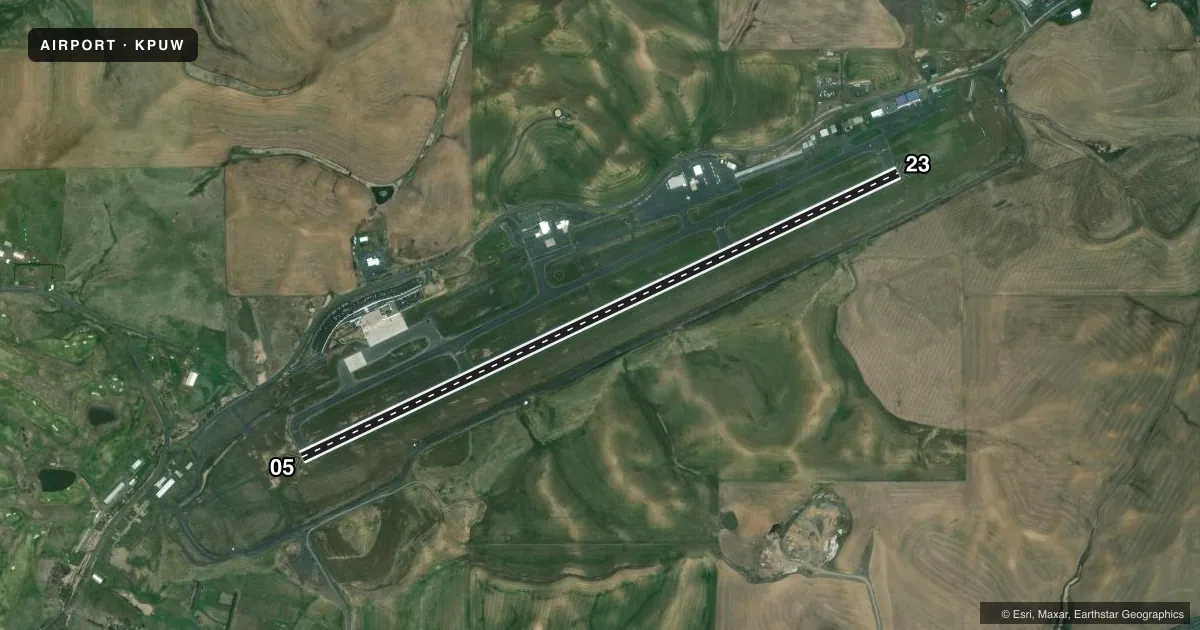
Airport sketch
Runways drawn to scale from FAA survey coordinates, rendered over satellite imagery. Not for navigation.
Approaches & charts
ILS · 1
Services on the field
Fuel grades, oxygen, maintenance, ramp storage and lighting — as declared to the FAA by the airport operator.
Fuel & services
- Fuel
- 100LLA
- Airframe repair
- Major
- Power plant repair
- Major
- Other services
- AFRT,AGRI,CHTR,INSTR,RNTL
Ramp & ground
- Transient storage
- Tie-down
- Landing fee
- Yes
- Customs
- Not available
- Lighting schedule
- SEE RMK
- Beacon schedule
- SS-SR
- Beacon
- White / Green (civil land)(WG)
- Wind indicator
- Lighted
- Segmented circle
- Yes
Fuel & FBOs
Cheapest 100LL and Jet A on the field and nearby. Always confirm with the FBO before taxi.
Airport notes
Surface conditions, obstructions, local procedures, lighting outages and other notes published with each FAA cycle.
General notes
- NON PAVED AREA OPS NA. PRKG BTN RWY & TWY NA.
- OBSTNS PENETRATE IMAGINARY SFCS N & S OF RWY.
- FOR CD IF UNA TO CTC ON FSS FREQ, CTC SEATTLE ARTCC AT 253-351-3694.
Lighting notes
- ACTVT MALSR RWY 05; REIL RWY 23; PAPI RWY 05 & 23; HIRL RWY 5/23 - CTAF.
Runway surface & condition
- 05/23PCR VALUE: 520/F/D/X/T
Other notes
- CLSD TO UNSKED ACR OPS GTR THAN 30 PAX SEATS EXC PPR - AMGR.
- COML & ITNRNT OVR 7000 LBS LNDG FEE.
VFR map & nearby airports
VFR sectional. Tap any ICAO chip to open that airport.
Key facts · KPUW
Answer card- ICAO
- KPUW
- Name
- PULLMAN/MOSCOW RGNL
- Location
- PULLMAN/MOSCOW, WASHINGTON
- Elevation
- 2,566.6 ft MSL
- Traffic pattern altitude
- 3,566.6 ft MSL (1,000 AGL)
- Control tower
- Non-towered (use CTAF)
- Total runways
- 1
- Longest runway
- 05/23 · 7,100 ft
- Published ILS approaches
- 1
- Published frequencies
- 2
- Magnetic variation
- 15°
- Current flight rules
- VFR
- Current wind
- 000° at 3 kt
- Favored runway now
- RWY 05
Pullman/Moscow Rgnl sits in Pullman and serves the Moscow area in Washington. Field elevation is 2,566.6 ft MSL. The airport has one runway, 05/23, which is 7,100 ft long. There is no control tower. CTAF and UNICOM are both 122.8.
Runway 05 has an ILS. The published lighting setup also includes MALSR on runway 05, REIL on runway 23, PAPI on both ends and high intensity runway lighting on 05/23 that is controlled by CTAF. Pattern altitude is not published. Use the standard 1,000 ft AGL for light piston traffic unless ATC or the airport has given you different guidance.
Inter-State Aviation is on the field. It carries 100LL, Jet A and Jet A Prist. The airport remarks also note that operations on non-paved areas are not authorized. Parking between the runway and taxiway is not authorized. There are obstructions north and south of the runway, so pay attention on departure and arrival. This field sits at higher elevation, so density altitude can matter on warm days. Commercial and itinerant aircraft over 7,000 lb are subject to a landing fee. Check the current FAA Chart Supplement for any current operational notes before you go.