METAR & TAF KLNS
Current METAR
Observed 07:53Z
KLNS 120753Z AUTO 27003KT 10SM CLR 21/20 A2979 RMK AO2 SLP084 T02110200 $
- Wind
- 270° @ 3 kt
- Visibility
- 10 SM
- Temp / Dew
- 21°C / 20°C
- Altimeter
- 29.79 inHg
- Clouds
- CLR
- Density alt
- 1,380 ft
- Ceiling
- Unlimited
- Rules
- VFR
Airport info & contacts
Manager on record, flight service, ARTCC, attendance schedule and pattern altitude — published by the FAA and refreshed every 28 days.
Location
- From city
- 4 NM N
- VFR sectional
- NEW YORK
- ARTCC
- ZNY · NEW YORK
- NOTAM facility
- LNS (NOTAM-D)
Airport manager
- Name
- ED FOSTER
- Phone
- 717-569-1221
- Address
- 500 AIRPORT RD SUITE G, LITITZ PA 17543-9340
Flight service · Hours
- FSS IPT
- WILLIAMSPORT1-800-WX-BRIEF
- Attendance
- DAILY · 0700-2100
Frequencies
Tap any row to copy the frequency to your clipboard.
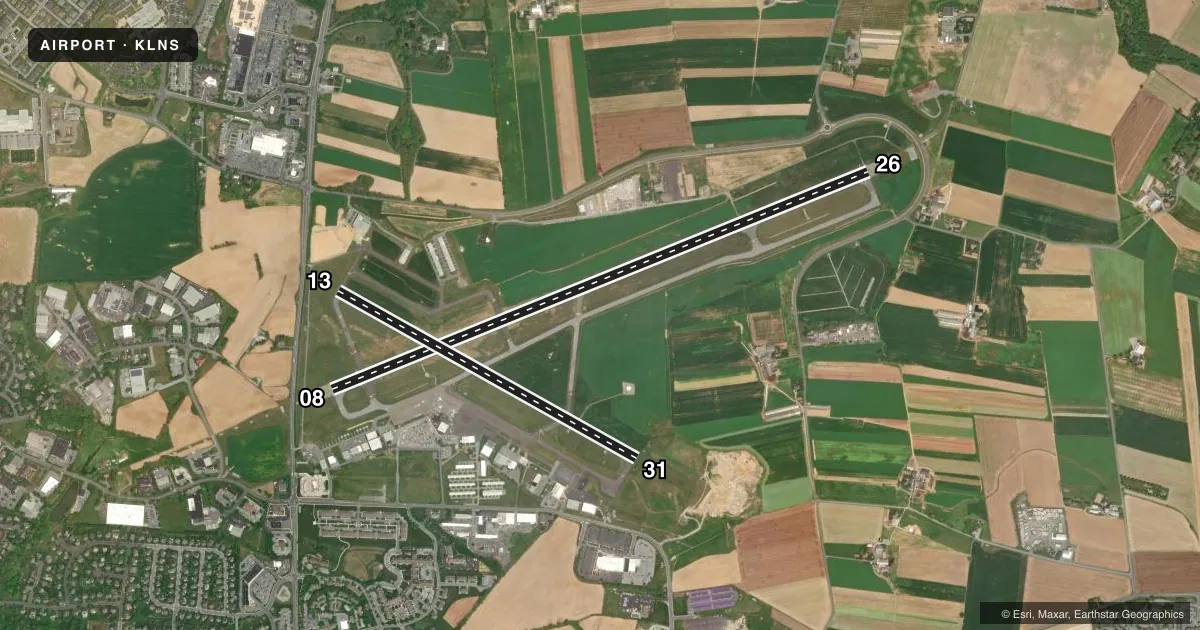
Runways & pattern
Full pagePattern entry · RWY 26
LEFT TRAFFIC| Runway | Heading (°M) | Length | Surface | Traffic |
|---|---|---|---|---|
| 08/26Favored | 59° / 239° | 6,933 ft | ASPH | Standard L |
| 13/31 | 110° / 290° | 4,102 ft | ASPH | Standard L |
Runway end performance
| End | TORA | TODA | ASDA | LDA | VGSI | Approach lights | Obstruction |
|---|---|---|---|---|---|---|---|
| 08 | 6,934' | 6,934' | 6,475' | 6,118' | PAPI 4-box right(3°) | MALSR | 5', road, 297' from thr, 380' R of cntrln, slope 20 |
| 26 | 6,934' | 6,934' | 6,177' | 6,118' | PAPI 4-box left(3°) | — | 40', tree, 1266' from thr, 276' R of cntrln, slope 26 |
| 13 | 4,102' | 4,102' | 4,102' | 4,102' | PAPI 2-box right(3°) | — | 76', tree, 1816' from thr, 477' R of cntrln, slope 21 |
| 31 | 4,102' | 4,102' | 4,102' | 4,102' | VASI 2-box left(3°) | — | 30', trees, 958' from thr, 330' R of cntrln, slope 25 |
Declared distances in feet. TORA = takeoff run available, TODA = takeoff distance, ASDA = accelerate-stop, LDA = landing distance.
Airport sketch
Runways drawn to scale from FAA survey coordinates, rendered over satellite imagery. Not for navigation.
Approaches & charts
ILS · 1
Services on the field
Fuel grades, oxygen, maintenance, ramp storage and lighting — as declared to the FAA by the airport operator.
Fuel & services
- Fuel
- 100LLA
- Oxygen (bottled)
- Low pressure
- Airframe repair
- Major
- Power plant repair
- Major
- Other services
- AMB,AVNCS,CHTR,INSTR,RNTL,SURV
Ramp & ground
- Transient storage
- Tie-down
- Hangar
- Landing fee
- No fee published
- Customs
- Not available
- Lighting schedule
- SEE RMK
- Beacon schedule
- SS-SR
- Beacon
- White / Green (civil land)(WG)
- Wind indicator
- Lighted
- Segmented circle
- No
Fuel & FBOs
Cheapest 100LL and Jet A on the field and nearby. Always confirm with the FBO before taxi.
Airport notes
Surface conditions, obstructions, local procedures, lighting outages and other notes published with each FAA cycle.
General notes
- RWY LGTS AND MALSR UNMONITORED WHEN TWR CLSD.
- RWY AND TWY CONDS NOT MNT OUTSIDE OF ARFF COVERAGE HRS.
- FOR CD WHEN ATCT CLSD, CTC HARRISBURG APCH AT 800-932-0712.
Lighting notes
- WHEN ATCT CLSD ACTVT MALSR RWY 08; REIL RWY 31; HIRL 08/26; MIRL RWY 13/31; TWY LGTS - CTAF.
Runway surface & condition
- 08/26PCR VALUE: 430/F/D/X/T
Approach & departure obstructions
- 08RWY 08 APCH RATIO 50:1 TO DTHR.
- 26RWY 26 APCH RATIO 33:1 TO DTHR.
Other notes
- PREDATES ACT.
- ARFF AVBL FM 0600-2100 MON-FRI, 0600-1800 SAT, 0800-2100 SUN. EMERGS OUTSIDE ATCT OPN HRS & ARFF HRS CALL MANHEIM TOWNSHIP EMERG SVCS AT 911.
VFR map & nearby airports
VFR sectional. Tap any ICAO chip to open that airport.
Key facts · KLNS
Answer card- ICAO
- KLNS
- Name
- LANCASTER
- Location
- LANCASTER, PENNSYLVANIA
- Elevation
- 402.6 ft MSL
- Traffic pattern altitude
- 1,402.6 ft MSL (1,000 AGL)
- Control tower
- Towered · 0600-2300
- Total runways
- 2
- Longest runway
- 08/26 · 6,933 ft
- Published ILS approaches
- 1
- Published frequencies
- 10
- Magnetic variation
- 9°
- Current flight rules
- VFR
- Current wind
- 270° at 3 kt
- Favored runway now
- RWY 26
Lancaster Airport sits in Lancaster, Pennsylvania. Field elevation is 402.6 ft MSL. The airport has 2 asphalt runways. The longest is runway 08/26 at 6,933 ft. Tower hours are 0600 to 2300. One ILS is published for runway 08. Pattern altitude is not published, so use the standard 1,000 ft AGL for light piston traffic unless the current Chart Supplement says otherwise.
LNS Alliance Aviation is on the field. It carries 100LL, Jet A and Jet A Prist. If you need fuel or ramp details, call them at (717) 735-9507 before you go. The published remarks also matter here. Runway and taxiway conditions are not maintained outside aircraft rescue and fire fighting coverage hours. When the tower is closed, runway and taxiway lighting is unmonitored. Runway 08 has an obstacle clearance note on approach. Runway 26 does too.
For a first-time arrival, pay attention to the tower schedule and the lighting setup after hours. The airport also publishes Harrisburg Approach as the contact for clearance delivery when the tower is closed. Check the current Chart Supplement for any noise or curfew restrictions before flying into the field. Expect a controlled airport with active traffic. Plan your arrival with the published frequencies and runway layout in mind.