METAR & TAF KLMT
Current METAR
Observed 15:53Z
KLMT 271553Z 00000KT 10SM CLR 18/09 A3016 RMK AO2 SLP170 T01830094
- Wind
- 000° @ 0 kt
- Visibility
- 10 SM
- Temp / Dew
- 18°C / 9°C
- Altimeter
- 30.16 inHg
- Clouds
- CLR
- Density alt
- 5,141 ft
- Ceiling
- Unlimited
- Rules
- VFR
Airport info & contacts
Manager on record, flight service, ARTCC, attendance schedule and pattern altitude — published by the FAA and refreshed every 28 days.
Location
- From city
- 4 NM SE
- VFR sectional
- KLAMATH FALLS
- ARTCC
- ZSE · SEATTLE
- NOTAM facility
- LMT (NOTAM-D)
Airport manager
- Name
- JONATHAN TEICHERT
- Phone
- 541-883-5373
- Address
- 3000 AIRPORT WAY STE. 300, KLAMATH FALLS OR 97603
Flight service · Hours
- FSS MMV
- MC MINNVILLE1-800-WX-BRIEF
- Attendance
- MON-FRI · 0630-1700
Frequencies
Tap any row to copy the frequency to your clipboard.
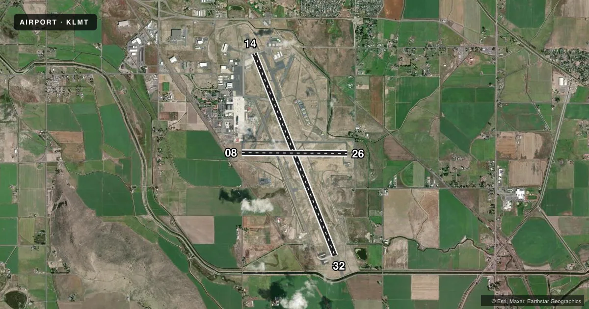
Runways & pattern
Full pagePattern entry · RWY 14
LEFT TRAFFIC| Runway | Heading (°M) | Length | Surface | Traffic |
|---|---|---|---|---|
| 14/32 | 144° / 324° | 10,302 ft | ASPH-CONC | Standard L |
| 08/26 | 76° / 256° | 5,001 ft | ASPH | Standard L |
Runway end performance
| End | TORA | TODA | ASDA | LDA | VGSI | Approach lights | Obstruction |
|---|---|---|---|---|---|---|---|
| 14 | 10,302' | 10,302' | 10,302' | 10,302' | PAPI 4-box left(3.2°) | MALSF | — |
| 32 | 10,302' | 10,302' | 10,302' | 10,302' | VASI 4-box left(3°) | MALSR | — |
| 08 | 5,001' | 5,001' | 5,001' | 5,001' | — | — | 25', rr, 625' from thr, 125' R of cntrln, slope 16 |
| 26 | 5,001' | 5,001' | 5,001' | 5,001' | PAPI 4-box left(3°) | — | 8', fence, 86' from thr, 125' R of cntrln, slope 0 |
Declared distances in feet. TORA = takeoff run available, TODA = takeoff distance, ASDA = accelerate-stop, LDA = landing distance.
Airport sketch
Runways drawn to scale from FAA survey coordinates, rendered over satellite imagery. Not for navigation.
Approaches & charts
ILS · 2
Services on the field
Fuel grades, oxygen, maintenance, ramp storage and lighting — as declared to the FAA by the airport operator.
Fuel & services
- Fuel
- 100LLAA++
- Oxygen (bottled)
- High pressure
- Oxygen (bulk)
- High pressure
- Airframe repair
- Major
- Power plant repair
- Major
- Other services
- AFRT,AGRI,CARGO,CHTR,INSTR
Ramp & ground
- Transient storage
- Tie-down
- Hangar
- Landing fee
- Yes
- Customs
- Not available
- Lighting schedule
- SEE RMK
- Beacon schedule
- SS-SR
- Beacon
- White / Green (civil land)(WG)
- Wind indicator
- Lighted
- Segmented circle
- Yes
Fuel & FBOs
Cheapest 100LL and Jet A on the field and nearby. Always confirm with the FBO before taxi.
Airport notes
Surface conditions, obstructions, local procedures, lighting outages and other notes published with each FAA cycle.
General notes
- MIL BASH PHASE II - FEB - MAY & SEP - NOV. OTR TIMES BASH PHASE I.
- WATERFOWL INVOF ARPT NOV-MAY.
- MIL ANG: HVY ACFT AFT LNDG TAX TO N OR S EOR; SHTDN OUTBOARD ENGS BFR TAX TO MIL RAMP.
- CSTMS/AG/IMG SVC NA. KPDX CUST - C503-326-3249.
- ANG: OFFL BUS, PPR COMM 541-885-6686. BASE OPS OPR 1430-2359Z++ MON-+FRI EXC HOL.
- MIL FUEL SVC 1500-0300Z++; 20 MIN PRIOR NOTICE & FEE - C541-882-4681
- RSTD: TWY A WEST OF TWY D & TWY D BTN TWY E & F MIL OPS ONLY.
- FBO - 541-882-4681.
- TWY G SOUTH RUN UP PAD MIL OPS ONLY.
- CONDS UNMTR WKDAY 2230 - 0630, WKEND & HOL.
- FOR CD IF UNA TO CTC ON FSS FREQ, CTC SEATTLE ARTCC AT 253-351-3694.
- MIL ANG: CLASSIFIED MTRL STORAGE SECRET & BLW - AMGMT.
- RSTD: TWY G S RUN UP PAD MIL OPS ONLY. TWY B BTN TWY B1 & TWY B2 WINGTIP TO FIXED OBJECT SEPARATION NSTD; WINGSPAN GREATER THAN 133 FT MINIMIZE TAXI SPEED.
Lighting notes
- WHEN ATCT CLSD ACTVT MALSF RWY 14, MALSR RWY 32, HIRL RWY 14/32, MIRL RWY 08/26 & TWY LGTS - CTAF. RWY & TWY LGTS ALSO ACTVT ON 257.8. REIL RWY 26; PAPI RWY 26, PAPI RWY 14 & VASI RWY 32 OPR CONSLY.
Runway surface & condition
- 08/26PCR VALUE: 110/F/A/X/T
- 14/32PCR VALUE: 560/F/A/W/T
Approach & departure obstructions
- 14RWY 14 PAPI UNUSBL BYD 3.5 NM.
- 08APCH SLOPE 29:1 TO DTHR.
- 26APCH SLOPE 34:1 TO DTHR.
Arresting gear
- 14_BAK-12TYPE H BAK-12B(B)(1500')
- 32_BAK-12TYPE H BAK-12B(B)(1500')
Other notes
- 1UNATNDD WKEND & HOL.
- MANAGER541-539-8977.
VFR map & nearby airports
VFR sectional. Tap any ICAO chip to open that airport.
Key facts · KLMT
Answer card- ICAO
- KLMT
- Name
- CRATER LAKE/KLAMATH RGNL
- Location
- KLAMATH FALLS, OREGON
- Elevation
- 4,095.4 ft MSL
- Traffic pattern altitude
- 5,095.4 ft MSL (1,000 AGL)
- Control tower
- Towered · 0700-2000
- Total runways
- 2
- Longest runway
- 14/32 · 10,302 ft
- Published ILS approaches
- 2
- Published frequencies
- 11
- Magnetic variation
- 14°
- Current flight rules
- VFR
- Current wind
- 000° at 0 kt
- Favored runway now
- –
Crater Lake/Klamath Rgnl Airport sits in Klamath Falls, Oregon. Field elevation is 4,095.4 ft MSL. The airport has two runways. The longest is runway 14/32 at 10,302 ft. Runway 08/26 is 5,001 ft. The tower is open 0700 to 2000. Two ILS approaches are published. They serve runway ends 14 and 32.
Pattern altitude is not published in the facts. Use the standard 1,000 ft AGL for light piston traffic unless the current FAA Chart Supplement says otherwise. That puts the pattern about 5,095 ft MSL based on field elevation, but verify before you fly. The airport is high enough that density altitude can matter, especially on warm days. Expect performance planning to matter more than at a low-elevation field.
Century Aviation Services and RMC Aviation are on the field. Both carry 100LL and Jet A. Century Aviation Services also carries Jet A Prist. RMC Aviation also carries Jet A Prist. Waterfowl are reported in the area from November through May. Some taxiways and the south run-up pad are restricted to military use. When the tower is closed, lighting is activated on CTAF or on 257.8. Check the current FAA Chart Supplement for any current operating notes before arrival.