METAR & TAF KGDM
KGDM does not publish a METAR.
Showing the nearest reporting station: KFIT (FITCHBURG MUNI) · 11.4 NM away. Conditions at KGDM may differ.
METAR · KFIT
Observed 04:52Z
KFIT 120452Z AUTO 33003KT 10SM CLR 25/21 A2970 RMK AO2 SLP056 T02500206 403390217
- Wind
- 330° @ 3 kt
- Visibility
- 10 SM
- Temp / Dew
- 25°C / 21°C
- Altimeter
- 29.70 inHg
- Clouds
- CLR
- Density alt
- 2,656 ft
- Ceiling
- Unlimited
- Rules
- VFR
Airport info & contacts
Manager on record, flight service, ARTCC, attendance schedule and pattern altitude — published by the FAA and refreshed every 28 days.
Location
- From city
- 2 NM SW
- VFR sectional
- NEW YORK
- ARTCC
- ZBW · BOSTON
- NOTAM facility
- BDR (NOTAM-D)
Airport manager
- Name
- ISABELLE DAVIS
- Phone
- 978-790-7779
- Address
- GARDNER CITY HALL, 95 PLEASANT ST, ROOM 214, GARDNER MA 01440
Flight service · Hours
- FSS BDR
- BRIDGEPORT1-800-WX-BRIEF
- Attendance
- IREG
Frequencies
Tap any row to copy the frequency to your clipboard.
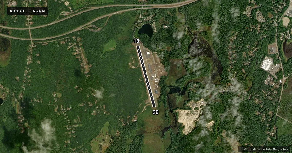
Runways & pattern
Full pagePattern entry · RWY 36
LEFT TRAFFICRunway end performance
| End | TORA | TODA | ASDA | LDA | VGSI | Approach lights | Obstruction |
|---|---|---|---|---|---|---|---|
| 18 | — | — | — | — | — | — | 150', trees, 800' from thr, 130' R of cntrln, slope 4 |
| 36 | — | — | — | — | — | — | 15', trees, 300' from thr, 125' R of cntrln, slope 6 |
Declared distances in feet. TORA = takeoff run available, TODA = takeoff distance, ASDA = accelerate-stop, LDA = landing distance.
Airport sketch
Runways drawn to scale from FAA survey coordinates, rendered over satellite imagery. Not for navigation.
Approaches & charts
Services on the field
Fuel grades, oxygen, maintenance, ramp storage and lighting — as declared to the FAA by the airport operator.
Fuel & services
- Fuel
- 100LL
- Oxygen (bottled)
- Not available
- Oxygen (bulk)
- Not available
- Airframe repair
- Minor
- Power plant repair
- Minor
Ramp & ground
- Transient storage
- Tie-down
- Landing fee
- No fee published
- Customs
- Not available
- Lighting schedule
- SEE RMK
- Beacon schedule
- SS-SR
- Beacon
- White / Green (civil land)(WG)
- Wind indicator
- Yes
- Segmented circle
- No
Fuel & FBOs
Cheapest 100LL and Jet A on the field and nearby. Always confirm with the FBO before taxi.
Airport notes
Surface conditions, obstructions, local procedures, lighting outages and other notes published with each FAA cycle.
General notes
- NORDO ACFT ON AND INVOF ARPT.
- WILDLIFE ON AND IN VCNTY OF ARPT.
Lighting notes
- ACTVT REIL RWY 18 & 36; MIRL RWY 18/36 - CTAF.
Other notes
- ESTAB PRIOR TO 1959.
VFR map & nearby airports
VFR sectional. Tap any ICAO chip to open that airport.
Key facts · KGDM
Answer card- ICAO
- KGDM
- Name
- GARDNER MUNI
- Location
- GARDNER, MASSACHUSETTS
- Elevation
- 954.1 ft MSL
- Traffic pattern altitude
- 1,954.1 ft MSL (1,000 AGL)
- Control tower
- Non-towered (use CTAF)
- Total runways
- 1
- Longest runway
- 18/36 · 3,001 ft
- Published ILS approaches
- 0
- Published frequencies
- 2
- Magnetic variation
- 14°
- Current flight rules
- VFR
- Current wind
- 330° at 3 kt
- Favored runway now
- RWY 36
Gardner Muni sits in Gardner, Massachusetts. The field elevation is 954.1 ft MSL. It has one runway, 18/36, at 3,001 ft asphalt. There is no control tower. CTAF and UNICOM are both 122.8. No ILS approaches are published here.
Pattern altitude is not published. Use the standard 1,000 ft AGL pattern unless the current Chart Supplement or local procedures say otherwise. Gardner Aviation Services is on the field. It carries 100LL. Call (978) 821-2803 for current service details before you go.
A few published remarks matter here. NORDO aircraft are on and in the vicinity of the airport. Wildlife is also on and in the vicinity of the airport. Runway end identifier lights are active on 18 and 36. Medium intensity runway lights are on 18 and 36. They are controlled by the common traffic advisory frequency. For a first-time arrival, plan for an uncontrolled field with local traffic, possible wildlife and a relatively short paved runway at a higher-than-sea-level elevation. Check the current Chart Supplement for any local notes before departure.