METAR & TAF KFCM
Current METAR
Observed 22:53Z
KFCM 272253Z 32010KT 9SM CLR 34/18 A2971 RMK AO2 SLP051 T03440178
- Wind
- 320° @ 10 kt
- Visibility
- 9 SM
- Temp / Dew
- 34°C / 18°C
- Altimeter
- 29.71 inHg
- Clouds
- CLR
- Density alt
- 3,664 ft
- Ceiling
- Unlimited
- Rules
- VFR
Airport info & contacts
Manager on record, flight service, ARTCC, attendance schedule and pattern altitude — published by the FAA and refreshed every 28 days.
Location
- From city
- 11 NM SW
- VFR sectional
- TWIN CITIES
- ARTCC
- ZMP · MINNEAPOLIS
- NOTAM facility
- FCM (NOTAM-D)
Airport manager
- Name
- ROBERT DOCKRY
- Phone
- 952-944-1035
- Address
- 9960 FLYING CLOUD DRIVE, EDEN PRAIRIE MN 55347-4016
Flight service · Hours
- FSS PNM
- PRINCETON1-800-WX-BRIEF
- Attendance
- ALL
Frequencies
Tap any row to copy the frequency to your clipboard.
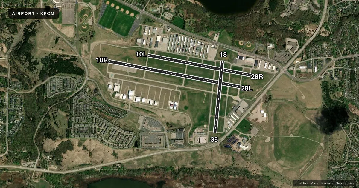
Runways & pattern
Full pagePattern entry · RWY 28L
LEFT TRAFFIC| Runway | Heading (°M) | Length | Surface | Traffic |
|---|---|---|---|---|
| 10R/28LFavored | 98° / 278° | 5,001 ft | ASPH | 10R R |
| 10L/28R | 98° / 278° | 3,901 ft | ASPH | 28R R |
| 18/36 | 183° / 3° | 2,690 ft | ASPH | Standard L |
Runway end performance
| End | TORA | TODA | ASDA | LDA | VGSI | Approach lights | Obstruction |
|---|---|---|---|---|---|---|---|
| 10R | — | — | — | — | PAPI 4-box left(3°) | MALSR | 61', tree, 3085' from thr, 131' R of cntrln, slope 47 |
| 28L | — | — | — | — | PAPI 4-box left(3°) | — | — |
| 10L | — | — | — | — | PAPI 4-box left(3°) | — | — |
| 28R | — | — | — | — | PAPI 4-box left(3°) | — | — |
| 18 | — | — | — | — | PAPI 4-box left(3.5°) | — | 48', tank, 907' from thr, 262' R of cntrln, slope 14 |
| 36 | — | — | — | — | PAPI 4-box left(3°) | — | 4', fence, 219' from thr, 151' R of cntrln, slope 5 |
Declared distances in feet. TORA = takeoff run available, TODA = takeoff distance, ASDA = accelerate-stop, LDA = landing distance.
Airport sketch
Runways drawn to scale from FAA survey coordinates, rendered over satellite imagery. Not for navigation.
Approaches & charts
ILS · 1
Services on the field
Fuel grades, oxygen, maintenance, ramp storage and lighting — as declared to the FAA by the airport operator.
Fuel & services
- Fuel
- 100LLA
- Oxygen (bottled)
- HIGH/LOW
- Airframe repair
- Major
- Power plant repair
- Major
- Other services
- AMB,AVNCS,CHTR,INSTR,RNTL,SALES
Ramp & ground
- Transient storage
- Tie-down
- Hangar
- Landing fee
- Yes
- Customs
- Not available
- Lighting schedule
- SEE RMK
- Beacon schedule
- SS-SR
- Beacon
- White / Green (civil land)(WG)
- Wind indicator
- Lighted
- Segmented circle
- No
Fuel & FBOs
Cheapest 100LL and Jet A on the field and nearby. Always confirm with the FBO before taxi.
Airport notes
Surface conditions, obstructions, local procedures, lighting outages and other notes published with each FAA cycle.
General notes
- DEER, BIRDS & WILDLIFE ON AND INVOF ARPT.
- ARPT CLSD TO: JETS NOT MEETING FAR 36, JET TRNG & ACFT W/ CERTIFICATED MGTOW HIGHER THAN 60,000 LBS.
- ULTRALIGHT OPNS PROHIBITED.
- MAINTENANCE RUN-UPS ARE PROHIBITED BTN 2200-0700 LCL.
- WHEN ATCT CLSD, SNOW REMOVAL OPS MONITOR 119.15.
- RWY 10R IS CALM WIND RWY WHEN ATCT CLSD.
- TWY 'D' CLOSED FM TWY 'D2' TO APCH END RWY 36 TO ACFT WITH WINGSPANS OF 66 FT OR GREATER.
- TWY A CLSD EAST OF BARON LANE TO ACFT WITH WINGSPANS 54 FT OR GREATER.
- WRWY INCURSION RISK - PILOTS ARE REMINDED TO REVIEW ARPT HOT SPOT INFO BFR TXG FOR DEP & BFR LDG. SEE TPP ARPT DIAGRAM & CHART SUPPL SXN ON HOT SPOTS FOR ADDN INFO.
- WRONG RWY ARR RISK, CLOSELY ALIGNED PARL RWYS. SEE TPP ARPT DIAGRAM.
- TWY D BTWN D1 & D2 CLSD TO ACFT WINGSPANS 48 FT OR GTR.
- TXL G CLSD TO WINGSPANS GTR THAN 43 FT.
- TXL H CLSD TO WINGSPANS GTR THAN 40 FT.
- FOR CD WHEN ATCT CLSD CTC MINNEAPOLIS APCH 121.7.
Lighting notes
- WHEN ATCT CLSD ACTVT OR INCR INTST MALSR RWY 10R; REIL RWY 28L, 18, & 36; PAPI RWY 10R, 28L, 18, & 36; HIRL RWY 10R/28L; MIRL RWY 18/36 - CTAF.
Fuel notes
- AJET A LDG FEE, CTC FBO.
Runway surface & condition
- 10L/28RCLSD WHEN ATCT CLSD.
Approach & departure obstructions
- 36RWY 36 HAS 5 FT FENCE 129 FT FROM THE RWY END AND 244 FT R.
- 36RY 36 PAPI UNUSBL BYD 6 DEG LEFT OF CNTRLN.
Other notes
- MANAGERROBERT.DOCKRY@MSPMAC.ORG.
- MANAGERARPT OFC NR 952-944-1035.
VFR map & nearby airports
VFR sectional. Tap any ICAO chip to open that airport.
Key facts · KFCM
Answer card- ICAO
- KFCM
- Name
- FLYING CLOUD
- Location
- MINNEAPOLIS, MINNESOTA
- Elevation
- 906.2 ft MSL
- Traffic pattern altitude
- 1,906.2 ft MSL (1,000 AGL)
- Control tower
- Towered · 0600-2100, 1ST SUN IN NOV-2ND SAT IN MAR; 0600-2200, 2ND SUN IN MAR-1ST SAT IN NOV.
- Total runways
- 3
- Longest runway
- 10R/28L · 5,001 ft
- Published ILS approaches
- 1
- Published frequencies
- 14
- Magnetic variation
- 3°
- Current flight rules
- VFR
- Current wind
- 320° at 10 kt
- Favored runway now
- RWY 28L
Flying Cloud Airport sits in Minneapolis, Minnesota. Field elevation is 906.2 ft MSL. The airport has 3 asphalt runways. The longest is 5,001 ft on 10R/28L. The tower is open 0600-2100 local from the first Sunday in November through the second Saturday in March. It is open 0600-2200 local from the second Sunday in March through the first Saturday in November. One ILS is published for runway 10R.
Pattern altitude is not published. Use the standard 1,000 ft AGL for light piston traffic unless ATC or the current Chart Supplement says otherwise. That puts the pattern around 1,906 ft MSL based on the field elevation. The airport has closely aligned parallel runways. Wrong-runway risk is real. Review the airport diagram before taxi and before landing. Runway incursion risk is also called out in the published remarks.
On the field, Thunderbird Aviation carries 100LL and Jet A Prist. Premier Jet Center carries 100LL, Jet A and Jet A Prist. Inflight Aviation carries 100LL and Jet A Prist. Deer, birds and wildlife are reported on and near the airport. Maintenance run-ups are prohibited between 2200 and 0700 local time. Taxiway G is closed to wingspans greater than 43 ft. Taxiway A is closed east of Baron Lane to aircraft with wingspans 54 ft or greater. The airport is closed to jets not meeting FAR 36, jet training and aircraft over 60,000 lb certificated max gross takeoff weight.