METAR & TAF KDAL
Current METAR
Observed 08:53Z
KDAL 270853Z 18007KT 10SM CLR 29/20 A2993 RMK AO2 SLP126 T02940200 58004 $
- Wind
- 180° @ 7 kt
- Visibility
- 10 SM
- Temp / Dew
- 29°C / 20°C
- Altimeter
- 29.93 inHg
- Clouds
- CLR
- Density alt
- 2,271 ft
- Ceiling
- Unlimited
- Rules
- VFR
Airport info & contacts
Manager on record, flight service, ARTCC, attendance schedule and pattern altitude — published by the FAA and refreshed every 28 days.
Location
- From city
- 5 NM NW
- VFR sectional
- DALLAS-FT WORTH
- ARTCC
- ZFW · FORT WORTH
- NOTAM facility
- DAL (NOTAM-D)
Airport manager
- Name
- PATRICK CARRENO
- Phone
- 214-670-5683
- Address
- DEPARTMENT OF AVIATION, 7555 LEMMON AVENUE, DALLAS TX 75209
Flight service · Hours
- FSS FTW
- FORT WORTH1-800-WX-BRIEF
- Attendance
- ALL
Frequencies
Tap any row to copy the frequency to your clipboard.
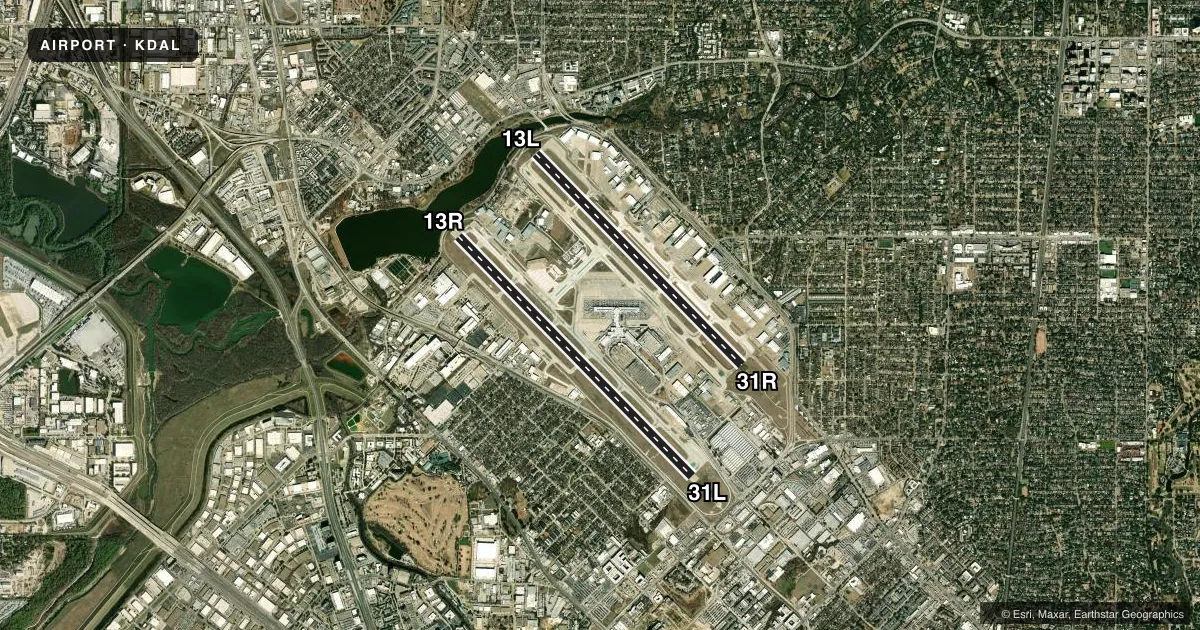
Runways & pattern
Full pagePattern entry · RWY 13R
RIGHT TRAFFIC| Runway | Heading (°M) | Length | Surface | Traffic |
|---|---|---|---|---|
| 13R/31LFavored | 133° / 313° | 8,800 ft | CONC | 13R R |
| 13L/31R | 133° / 313° | 7,752 ft | CONC | 31R R |
Runway end performance
| End | TORA | TODA | ASDA | LDA | VGSI | Approach lights | Obstruction |
|---|---|---|---|---|---|---|---|
| 13R | 8,800' | 8,800' | 8,800' | 8,310' | PAPI 4-box right(3°) | — | — |
| 31L | 8,800' | 8,800' | 8,000' | 8,000' | PAPI 4-box left(3.08°) | MALSR | 692', bldg, 21555' from thr, 2102' R of cntrln, slope 30 |
| 13L | 7,752' | 7,752' | 7,752' | 7,352' | PAPI 4-box right(3°) | MALSR | — |
| 31R | 7,752' | 7,752' | 6,952' | 6,952' | PAPI 4-box left(3°) | MALSR | 30', pole, 1227' from thr, 628' R of cntrln, slope 34 |
Declared distances in feet. TORA = takeoff run available, TODA = takeoff distance, ASDA = accelerate-stop, LDA = landing distance.
Airport sketch
Runways drawn to scale from FAA survey coordinates, rendered over satellite imagery. Not for navigation.
Approaches & charts
ILS · 4
Services on the field
Fuel grades, oxygen, maintenance, ramp storage and lighting — as declared to the FAA by the airport operator.
Fuel & services
- Fuel
- 100LLA
- Oxygen (bottled)
- HIGH/LOW
- Oxygen (bulk)
- HIGH/LOW
- Airframe repair
- Major
- Power plant repair
- Major
- Other services
- AMB,AVNCS,CHTR,INSTR,RNTL,SALES
Ramp & ground
- Transient storage
- Tie-down
- Hangar
- Landing fee
- No fee published
- Customs
- Not available
- Lighting schedule
- SS-SR
- Beacon schedule
- SS-SR
- Beacon
- White / Green (civil land)(WG)
- Wind indicator
- Lighted
- Segmented circle
- No
Fuel & FBOs
Cheapest 100LL and Jet A on the field and nearby. Always confirm with the FBO before taxi.
Airport notes
Surface conditions, obstructions, local procedures, lighting outages and other notes published with each FAA cycle.
General notes
- NOISE SENSITIVE AREAS ALL QUADRANTS; NOISE ABATEMENT PROCEDURES IN EFFECT JET AND AIRCRAFT OVER 12,500 LBS USE RWY 13R/31L BETWEEN 2100-0600 LCL. FOR INFORMATION CALL 214-670-5683.
- BIRDS ON & INVOF ARPT. BIRD ACTIVITY TRINITY RIVER BOTTOM 3 MILES SW SIDE
- PVT PILOT CERT OR BTR RQRD TO TKOF OR LAND.
- NO STUDENT SOLO FLIGHTS PERMITTED.
- TWY K CLSD THRU TRAFFIC.
- PAEW ON ARPT.
- TWY ALL CLSD TO ACFT WITH WINGSPAN 118 FT AND GTR EXC 1 HR PPR. 214-288-3069.
- LDG FEE APRT
- ACFT USING K RUNUP PAD BTN 0600-0000 MUST OBTAIN APVL FM ARPT OPNS CNTR 214-670-5683 PRIOR TO ENTERING.
- K RUNUP PAD CLSD 0000-0600.
- PILOTS CONDUCTING EFVS OPS; BE AWARE LED ALS IN USE RWY 31L & RWY 31R.
Runway surface & condition
- 13L/31RPCR VALUE: 450/R/B/W/T
- 13R/31LPCR VALUE: 865/R/D/W/T
Approach & departure obstructions
- 13RAPCH SLOPE 50:1 FM DSPLCD THR.
VFR map & nearby airports
VFR sectional. Tap any ICAO chip to open that airport.
Key facts · KDAL
Answer card- ICAO
- KDAL
- Name
- DALLAS LOVE FLD
- Location
- DALLAS, TEXAS
- Elevation
- 486.9 ft MSL
- Traffic pattern altitude
- 1,486.9 ft MSL (1,000 AGL)
- Control tower
- Towered · 24
- Total runways
- 2
- Longest runway
- 13R/31L · 8,800 ft
- Published ILS approaches
- 4
- Published frequencies
- 27
- Magnetic variation
- 3°
- Current flight rules
- VFR
- Current wind
- 180° at 7 kt
- Favored runway now
- RWY 13R
Dallas Love Field sits in Dallas, Texas. Field elevation is 486.9 ft MSL. The airport has 2 concrete runways. The longest is 8,800 ft. Tower service is published 24 hours a day. Four ILS approaches are published for the field. They serve runway ends 13L, 13R, 31L and 31R. Pattern altitude is not published in the facts, so verify the current Chart Supplement before you fly.
This is a busy Class B environment with noise-sensitive areas in all quadrants. Noise abatement procedures are in effect. Jet and aircraft over 12,500 lb use runway 13R/31L between 2100 and 0600 local time. Private pilot certificate or better is required to take off or land. No student solo flights are permitted. If you are new to the airport, plan for close ATC work. Expect a high-traffic metro field.
On the field, Signature Aviation is at Terminals 1, 3 and 4. Signature Aviation by Dalfort Fueling is at T2. Business Jet Center, Atlantic Aviation and Jet Aviation Dallas are also on the field. All listed FBOs carry 100LL and Jet A. Jet Aviation Dallas also carries Jet A Prist. Runway 31L and 31R use LED approach lighting. The airport also has a published runup pad restriction. Check the current Chart Supplement. Coordinate with airport operations if your route or aircraft needs special handling.