METAR & TAF KBIS
Current METAR
Observed 20:52Z
KBIS 272052Z VRB03KT 10SM CLR 33/12 A2988 RMK AO2 SLP109 T03330117 56006
- Wind
- VAR @ 3 kt
- Visibility
- 10 SM
- Temp / Dew
- 33°C / 12°C
- Altimeter
- 29.88 inHg
- Clouds
- CLR
- Density alt
- 4,270 ft
- Ceiling
- Unlimited
- Rules
- VFR
Airport info & contacts
Manager on record, flight service, ARTCC, attendance schedule and pattern altitude — published by the FAA and refreshed every 28 days.
Location
- From city
- 3 NM SE
- VFR sectional
- TWIN CITIES
- ARTCC
- ZMP · MINNEAPOLIS
- NOTAM facility
- BIS (NOTAM-D)
Airport manager
- Name
- GREGORY B HAUG
- Phone
- 701-355-1808
- Address
- BOX 991, BISMARCK ND 58502-0991
Flight service · Hours
- FSS GFK
- GRAND FORKS1-800-WX-BRIEF
- Attendance
- ALL
Frequencies
Tap any row to copy the frequency to your clipboard.
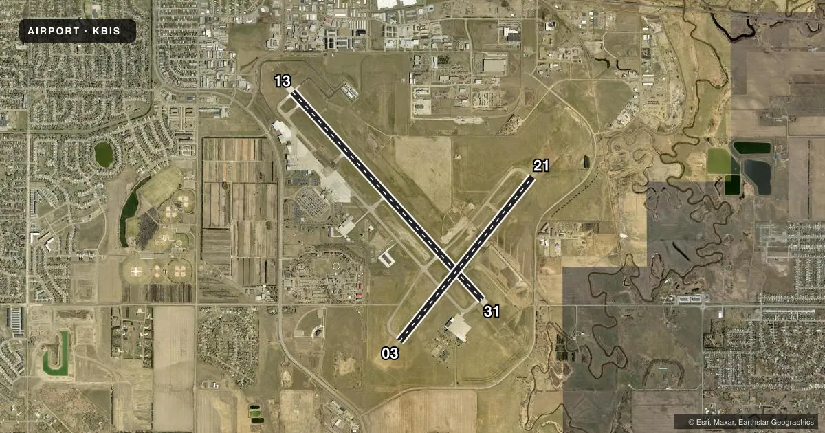
Runways & pattern
Full pagePattern entry · RWY 03
LEFT TRAFFIC| Runway | Heading (°M) | Length | Surface | Traffic |
|---|---|---|---|---|
| 13/31 | 131° / 311° | 8,794 ft | ASPH-CONC | Standard L |
| 03/21Favored | 32° / 212° | 6,600 ft | ASPH | Standard L |
Runway end performance
| End | TORA | TODA | ASDA | LDA | VGSI | Approach lights | Obstruction |
|---|---|---|---|---|---|---|---|
| 13 | 8,794' | 8,794' | 8,794' | 8,794' | PAPI 4-box left(3°) | MALS | 43', pole, 1662' from thr, 688' R of cntrln, slope 34 |
| 31 | 8,794' | 8,794' | 8,794' | 8,794' | PAPI 4-box left(3°) | MALSR | — |
| 03 | 6,600' | 6,600' | 6,600' | 6,600' | PAPI 4-box left(3°) | — | — |
| 21 | 6,600' | 6,600' | 6,600' | 6,600' | PAPI 4-box left(3°) | — | — |
Declared distances in feet. TORA = takeoff run available, TODA = takeoff distance, ASDA = accelerate-stop, LDA = landing distance.
Airport sketch
Runways drawn to scale from FAA survey coordinates, rendered over satellite imagery. Not for navigation.
Approaches & charts
ILS · 2
Services on the field
Fuel grades, oxygen, maintenance, ramp storage and lighting — as declared to the FAA by the airport operator.
Fuel & services
- Fuel
- 100LLA
- Oxygen (bottled)
- Not available
- Oxygen (bulk)
- HIGH/LOW
- Airframe repair
- Major
- Power plant repair
- Major
- Other services
- AFRT,AMB,AVNCS,CHTR,INSTR,RNTL,SALES
Ramp & ground
- Transient storage
- Tie-down
- Hangar
- Landing fee
- No fee published
- Customs
- Not available
- Lighting schedule
- SEE RMK
- Beacon schedule
- SS-SR
- Beacon
- White / Green (civil land)(WG)
- Wind indicator
- Lighted
- Segmented circle
- No
Fuel & FBOs
Cheapest 100LL and Jet A on the field and nearby. Always confirm with the FBO before taxi.
Airport notes
Surface conditions, obstructions, local procedures, lighting outages and other notes published with each FAA cycle.
General notes
- DEER, COYOTES & BIRDS ON & INVOF ARPT.
- RMKS-ARNG: OPR 1200-2130Z++ MON-FRI EXC HOL, PPR 24 PN RQR DSN 373-4071/70, C701-3334071/70. FW PAX TRML LCTD IN 'SE' HGR.
- FOR CD IF UNA TO CTC ON FSS FREQ, CTC MINNEAPOLIS ARTCC AT 651-463-5588.
Lighting notes
- WHEN ATCT CLSD HIRL RYS 13/31 & 03/21 PRESET MED INTST; PAPI RYS 13; 31; 03; & 21 ON; ACTVT MALS RY 13 & MALSR RY 31 - CTAF.
Fuel notes
- 100LLFOR FUEL CALL 701-223-4754 OR 701-258-5024.
Runway surface & condition
- 03/21PCR VALUE: 430/F/D/X/T
- 13/31PCR VALUE: 750/R/D/W/T
Approach & departure obstructions
- 03RESA NSTD.
- 21RESA NSTD.
Other notes
- MANAGER24HR CONTACT: OPERATIONS 701-220-9885.
VFR map & nearby airports
VFR sectional. Tap any ICAO chip to open that airport.
Key facts · KBIS
Answer card- ICAO
- KBIS
- Name
- BISMARCK MUNI
- Location
- BISMARCK, NORTH DAKOTA
- Elevation
- 1,661.3 ft MSL
- Traffic pattern altitude
- 2,661.3 ft MSL (1,000 AGL)
- Control tower
- Towered · 0600-2400
- Total runways
- 2
- Longest runway
- 13/31 · 8,794 ft
- Published ILS approaches
- 2
- Published frequencies
- 10
- Magnetic variation
- 7°
- Current flight rules
- VFR
- Current wind
- 000° at 3 kt
- Favored runway now
- RWY 03
Bismarck Muni sits in Bismarck, North Dakota. The field elevation is 1,661.3 ft MSL. It has 2 asphalt runways. The longest is 13/31 at 8,794 ft. The airport is towered. Tower hours are 0600 to 2400. Two ILS approaches are published for runway ends 13 and 31.
Pattern altitude is not published in the facts. Use the standard 1,000 ft AGL for light piston traffic unless ATC or the current FAA Chart Supplement says otherwise. The airport sits in a busy controlled environment. Get the current airspace picture before you go. The published remarks also note deer, coyotes and birds on and near the field. That matters on departure and on short final.
On-field FBOs are Bismarck Aero Center and Executive Air Taxi Corporation. Both carry 100LL, Jet A and Jet A Prist. The published remarks say fuel requests should go to either FBO by phone. They also note prior permission is required 24 hours ahead for certain arrangements. When the tower is closed, the runway lights are preset to medium intensity. PAPI is available on both runways. The approach lighting setup on 13 and 31 is also published, so review the current Chart Supplement before a night arrival or a low-vis arrival.