METAR & TAF KBIH
Current METAR
Observed 09:56Z
KBIH 270956Z AUTO 30003KT 10SM CLR 18/03 A3003 RMK AO2 SLP110 T01780033
- Wind
- 300° @ 3 kt
- Visibility
- 10 SM
- Temp / Dew
- 18°C / 3°C
- Altimeter
- 30.03 inHg
- Clouds
- CLR
- Density alt
- 5,338 ft
- Ceiling
- Unlimited
- Rules
- VFR
Airport info & contacts
Manager on record, flight service, ARTCC, attendance schedule and pattern altitude — published by the FAA and refreshed every 28 days.
Location
- From city
- 2 NM E
- VFR sectional
- SAN FRANCISCO
- ARTCC
- ZOA · OAKLAND
- NOTAM facility
- BIH (NOTAM-D)
Airport manager
- Name
- ASHLEY HELMS
- Phone
- (760) 872-2971
- Address
- 703 AIRPORT ROAD, BISHOP CA 93514
Flight service · Hours
- FSS RAL
- RIVERSIDE1-800-WX-BRIEF
- Attendance
- 0800-1700
Frequencies
Tap any row to copy the frequency to your clipboard.
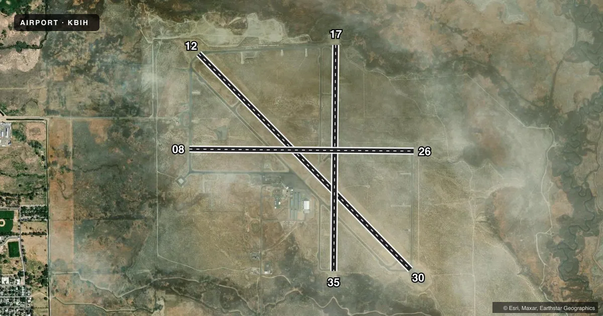
Runways & pattern
Full pagePattern entry · RWY 30
LEFT TRAFFIC| Runway | Heading (°M) | Length | Surface | Traffic |
|---|---|---|---|---|
| 12/30Favored | 120° / 300° | 7,498 ft | ASPH | Standard L |
| 17/35 | 165° / 345° | 5,600 ft | ASPH | Standard L |
| 08/26 | 75° / 255° | 5,567 ft | ASPH | Standard L |
Runway end performance
| End | TORA | TODA | ASDA | LDA | VGSI | Approach lights | Obstruction |
|---|---|---|---|---|---|---|---|
| 12 | 7,498' | 7,498' | 7,098' | 7,098' | PAPI 4-box left(3°) | — | — |
| 30 | 7,498' | 7,498' | 6,743' | 6,743' | PAPI 4-box left(3.52°) | — | 35', pline, 1555' from thr, 175' R of cntrln, slope 38 |
| 17 | — | — | — | — | PAPI 4-box left(3.5°) | — | — |
| 35 | — | — | — | — | PAPI 4-box left(3°) | — | 30', trees, 1442' from thr, slope 41 |
| 08 | — | — | — | — | PAPI 2-box left(3.5°) | — | 47', trees, 1350' from thr, 130' R of cntrln, slope 24 |
| 26 | — | — | — | — | PAPI 2-box left(3°) | — | — |
Declared distances in feet. TORA = takeoff run available, TODA = takeoff distance, ASDA = accelerate-stop, LDA = landing distance.
Airport sketch
Runways drawn to scale from FAA survey coordinates, rendered over satellite imagery. Not for navigation.
Approaches & charts
ILS · 1
Services on the field
Fuel grades, oxygen, maintenance, ramp storage and lighting — as declared to the FAA by the airport operator.
Fuel & services
- Fuel
- 100LLA
- Oxygen (bulk)
- Not available
- Airframe repair
- Not available
- Power plant repair
- Not available
- Other services
- AMB,INSTR
Ramp & ground
- Transient storage
- Tie-down
- Landing fee
- No fee published
- Customs
- Not available
- Lighting schedule
- SEE RMK
- Beacon schedule
- SS-SR
- Beacon
- White / Green (civil land)(WG)
- Wind indicator
- Lighted
- Segmented circle
- Yes
Fuel & FBOs
Cheapest 100LL and Jet A on the field and nearby. Always confirm with the FBO before taxi.
Airport notes
Surface conditions, obstructions, local procedures, lighting outages and other notes published with each FAA cycle.
General notes
- NO INTXN DEPS; HEL TFC APCH ARPT FM THE WEST BOUNDARY.
- RAMP FEES FOR COMM ACFT; MAY BE OFFSET WITH FUEL PURCHASE.
- OVNGT TIE-DOWN FEE; ONE NIGHT MAY BE OFFSET WITH MIN FUEL PURCHASE.
- FUEL DISCOUNTS FOR VOLUME PURCHASES.
- NO LOCAL TAXI SERVICE; DIAL-A-RIDE AVBL, BUT LTD ON SUN.
- FOR CD IF UNA TO CTC ON FSS FREQ, CTC OAKLAND ARTCC AT 510-745-3380.
- MAIN RAMP IS RSTRD TO PART 121; OTRS USE TSNT RAMP BY FUEL FARM.
Lighting notes
- ACTVT REIL RWY 12, 30, 17, & 35; PAPI RWY 08, 26, 12, 30, 17, & 35; MIRL RWY 08/26, 12/30, & 17/35 - CTAF.
Runway surface & condition
- 12/30PCR VALUE: 590/F/B/X/T
- 12/30PVD SHOULDER 10' TO LGTS PLUS 15' TO EDGE.
- 17/35PVD SHOULDER 10' TO LGTS PLUS 15' TO EDGE.
Approach & departure obstructions
- 2610' DEEP DITCH 100' FROM THR.
- 08PAPI UNUSBL BYD 5 NM.
- 17PAPI UNUSBL BYD 5 NM.
- 26PAPI UNUSBL BYD 2 NM.
- 30PAPI UNUSBL BYD 4 NM.
- 35PAPI UNUSBL BYD 5 NM.
Other notes
- 1CONDS NOT MNT BTN 1700-0800.
- 1ADMIN OFC AT ARPT 760-872-2971. AFTER HRS EMERG: 760-937-4017.
- MANAGERASHLEY HELMS, DEPUTY PUBLIC WORKS DIRECTOR - AIRPORTS; AHELMS@INYOCOUNTY.US.
- OWNERLEASED, CONSTRUCTED AND MAINTAINED BY INYO COUNTY. CITY OF LOS ANGELES IS UNDERLYING LAND OWNER - 300 MANDICH ST, BISHOP CA 93514
- INSTRHTTPS://BISHOPFLYING.CLUB/
VFR map & nearby airports
VFR sectional. Tap any ICAO chip to open that airport.
Key facts · KBIH
Answer card- ICAO
- KBIH
- Name
- BISHOP
- Location
- BISHOP, CALIFORNIA
- Elevation
- 4,124.3 ft MSL
- Traffic pattern altitude
- 5,124.3 ft MSL (1,000 AGL)
- Control tower
- Non-towered (use CTAF)
- Total runways
- 3
- Longest runway
- 12/30 · 7,498 ft
- Published ILS approaches
- 1
- Published frequencies
- 2
- Magnetic variation
- 15°
- Current flight rules
- VFR
- Current wind
- 300° at 3 kt
- Favored runway now
- RWY 30
Bishop Airport sits in Bishop, California. The field elevation is 4,124.3 ft MSL. It is an uncontrolled airport with CTAF and UNICOM both on 123.0. There are three asphalt runways. The longest is runway 12/30 at 7,498 ft. An ILS is available for runway 17.
Pattern altitude is not published. Use 1,000 ft AGL for light piston traffic unless the current Chart Supplement says otherwise. That puts the traffic pattern at about 5,124 ft MSL. Bishop Airport is a high-elevation field, so performance planning matters. Expect density altitude to be a factor on warm days. The airport is in a mountain valley setting, so watch climb performance and runway choice closely.
Bishop Airport is on the field. It carries 100LL, Jet A and Jet A Prist. The airport lighting is CTAF-controlled. REILs are available on runways 12, 30, 17 and 35. PAPI is available on all runway ends. Runway 17 has an ILS. The PAPI on 17 is unusable beyond 5 NM. No intersection departures are permitted. The main ramp is restricted to Part 121 operations. Other users should plan on the transient ramp by the fuel farm. Runway 26 also has a ditch about 100 ft from the threshold. Brief that side carefully before landing.