METAR & TAF KAUG
Current METAR
Observed 01:53Z
KAUG 280153Z AUTO VRB03KT 10SM CLR 19/11 A2982 RMK AO2 SLP096 T01890106
- Wind
- VAR @ 3 kt
- Visibility
- 10 SM
- Temp / Dew
- 19°C / 11°C
- Altimeter
- 29.82 inHg
- Clouds
- CLR
- Density alt
- 1,040 ft
- Ceiling
- Unlimited
- Rules
- VFR
Airport info & contacts
Manager on record, flight service, ARTCC, attendance schedule and pattern altitude — published by the FAA and refreshed every 28 days.
Location
- From city
- 1 NM NW
- VFR sectional
- MONTREAL
- Pattern altitude
- 1,048 ft AGL · 1,400 ft MSL
- ARTCC
- ZBW · BOSTON
- NOTAM facility
- AUG (NOTAM-D)
Airport manager
- Name
- JOHN GUIMOND
- Phone
- 207-626-2306
- Address
- 75 AIRPORT RD, AUGUSTA ME 04330
Flight service · Hours
- FSS BGR
- BANGOR1-800-WX-BRIEF
- Attendance
- 0700-2000
Frequencies
Tap any row to copy the frequency to your clipboard.
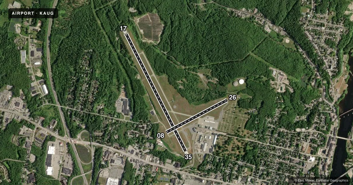
Runways & pattern
Full pagePattern entry · RWY 35
LEFT TRAFFIC| Runway | Heading (°M) | Length | Surface | Traffic |
|---|---|---|---|---|
| 17/35Favored | 135° / 315° | 5,002 ft | ASPH | Standard L |
| 08/26 | 44° / 224° | 2,613 ft | ASPH | Standard L |
Runway end performance
| End | TORA | TODA | ASDA | LDA | VGSI | Approach lights | Obstruction |
|---|---|---|---|---|---|---|---|
| 17 | 5,002' | 5,002' | 5,002' | 5,002' | PAPI 4-box left(3°) | MALSR | 6', tree, 210' from thr, 20' R of cntrln, slope 1 |
| 35 | 5,002' | 5,002' | 5,002' | 5,002' | PAPI 4-box left(3°) | — | 8', tree, 201' from thr, 90' R of cntrln, slope 0 |
| 08 | 2,613' | 2,613' | 2,613' | 2,613' | — | — | 16', trees, 287' from thr, 80' R of cntrln, slope 5 |
| 26 | 2,613' | 2,613' | 2,613' | 2,613' | — | — | 6', fence, 201' from thr, 131' R of cntrln, slope 0 |
Declared distances in feet. TORA = takeoff run available, TODA = takeoff distance, ASDA = accelerate-stop, LDA = landing distance.
Airport sketch
Runways drawn to scale from FAA survey coordinates, rendered over satellite imagery. Not for navigation.
Approaches & charts
ILS · 1
Services on the field
Fuel grades, oxygen, maintenance, ramp storage and lighting — as declared to the FAA by the airport operator.
Fuel & services
- Fuel
- 100LLA
- Oxygen (bottled)
- Not available
- Oxygen (bulk)
- Not available
- Airframe repair
- Major
- Power plant repair
- Major
- Other services
- AFRT,AMB,CHTR,INSTR,RNTL,SALES
Ramp & ground
- Transient storage
- Tie-down
- Hangar
- Landing fee
- Yes
- Customs
- Not available
- Lighting schedule
- SEE RMK
- Beacon schedule
- SS-SR
- Beacon
- White / Green (civil land)(WG)
- Wind indicator
- Lighted
- Segmented circle
- Yes
Fuel & FBOs
Cheapest 100LL and Jet A on the field and nearby. Always confirm with the FBO before taxi.
Airport notes
Surface conditions, obstructions, local procedures, lighting outages and other notes published with each FAA cycle.
General notes
- RWY 35 DESIGNATED CALM WIND RWY.
- TWY F EAST CLSD TO ALL ACFT WITH WING SPAN GTR THAN 45 FT.
- LDG FEE FOR MULTI-ENG ACFT; FEE WAIVED WITH FUEL PURCHASE.
- BIRDS & DEER ON & INVOF ARPT.
- ACR RAMP CLSD TO GA TFC.
- RWY 17/35 HAVE EMAS CATEGORY B2.
- FOR CD WHEN PORTLAND APCH CLSD, CTC BOSTON ARTCC AT 603-879-6859.
- PILOTS CONDUCTING EFVS OPS; BE AWARE LED ALS IN USE RWY 17.
Lighting notes
- ACTVT MALSR RWY 17; REIL RWY 35; PAPI RWY 17 & 35; HIRL RWY 17/35; MIRL RWY 08/26 - CTAF.
Fuel notes
- 100LLFOR FUEL AFT NML BUS HRS CALL 207-622-2507.
Approach & departure obstructions
- 177-8 FT BRUSH 190 FT FM THR, 110-120 FT R OF CNTRLN.
- 26ROAD & FENCE L OF APCH, 0-200 FT FM RWY END, LGTD.
- 35ROAD 240 FT R, 0-200 FT; 3-7 FT BRUSH 195-200 FT FM THR, 65-130 FT R OF CNTRLN.
- 17APCH SLP GTR THAN 45 DEG.
Arresting gear
- 17_EMASENGINEERED MATERIALS ARRESTING SYSTEM (EMAS) 130 FT IN LENGTH BY 122 FT IN WIDTH LCTD AT DER 17.
- 35_EMASENGINEERED MATERIALS ARRESTING SYSTEM (EMAS) 150 FT IN LENGTH BY 122 FT IN WIDTH LCTD AT DER 35.
Other notes
- EXISTED PRIOR TO 1959.
- CALL 207-622-1211 FOR HNGR AVBL.
- 1ARPT UNATNDD AFT DARK DURG SN & ICE SEASON. FLD COND RPRTS, SN DEPTHS & BA MAY NOT BE AVBL FOR RWYS FM 1800-0600.
VFR map & nearby airports
VFR sectional. Tap any ICAO chip to open that airport.
Key facts · KAUG
Answer card- ICAO
- KAUG
- Name
- AUGUSTA STATE
- Location
- AUGUSTA, MAINE
- Elevation
- 351.7 ft MSL
- Traffic pattern altitude
- 1,399.7 ft MSL (1,048 AGL)
- Control tower
- Non-towered (use CTAF)
- Total runways
- 2
- Longest runway
- 17/35 · 5,002 ft
- Published ILS approaches
- 1
- Published frequencies
- 6
- Magnetic variation
- 18°
- Current flight rules
- VFR
- Current wind
- 000° at 3 kt
- Favored runway now
- RWY 35
Augusta State Airport is in Augusta, Maine. Field elevation is 351.7 ft MSL. The airport has two asphalt runways. The longest is runway 17/35 at 5,002 ft. It is a non-towered field, so plan to self-announce on CTAF 123.0. The airport has one ILS approach. It serves runway 17. Pattern altitude is 1,048 ft AGL. That is 1,399.7 ft MSL.
Maine Instrument Flight is on the field. It carries 100LL, Jet A and Jet A Prist. If you need current ramp details or service status, call them at (207) 622-1211 before you go. Published remarks matter here. Taxiway F east is closed to aircraft with wingspans over 45 ft. There is an EMAS at the departure end of runway 17 and another at the departure end of runway 35. The field can be unattended after dark during snow and ice season. Field condition reports, snow depths and braking action may not be available from 1800 to 0600. Birds and deer are also noted in the airport area.
First-time pilots should pay attention to the runway-end obstacles and the runway 26 approach area. There is a road and fence left of the approach near runway 26. Runway 17 has brush near the threshold. Runway 35 has a road and brush right of the approach. Check the current FAA Chart Supplement before you fly for any updated procedures or restrictions.