METAR & TAF KABR
Current METAR
Observed 19:53Z
KABR 271953Z AUTO 32005KT 10SM CLR 31/19 A2985 RMK AO2 SLP097 T03110189
- Wind
- 320° @ 5 kt
- Visibility
- 10 SM
- Temp / Dew
- 31°C / 19°C
- Altimeter
- 29.85 inHg
- Clouds
- CLR
- Density alt
- 3,621 ft
- Ceiling
- Unlimited
- Rules
- VFR
Airport info & contacts
Manager on record, flight service, ARTCC, attendance schedule and pattern altitude — published by the FAA and refreshed every 28 days.
Location
- From city
- 2 NM E
- VFR sectional
- TWIN CITIES
- ARTCC
- ZMP · MINNEAPOLIS
- NOTAM facility
- ABR (NOTAM-D)
Airport manager
- Name
- RICH KROKEL
- Phone
- 605-626-7020
- Address
- 4740 6TH AVENUE SE, ABERDEEN SD 57401-4215
Flight service · Hours
- FSS HON
- HURON1-800-WX-BRIEF
- Attendance
- MON-FRI · 0330-2400L
Frequencies
Tap any row to copy the frequency to your clipboard.
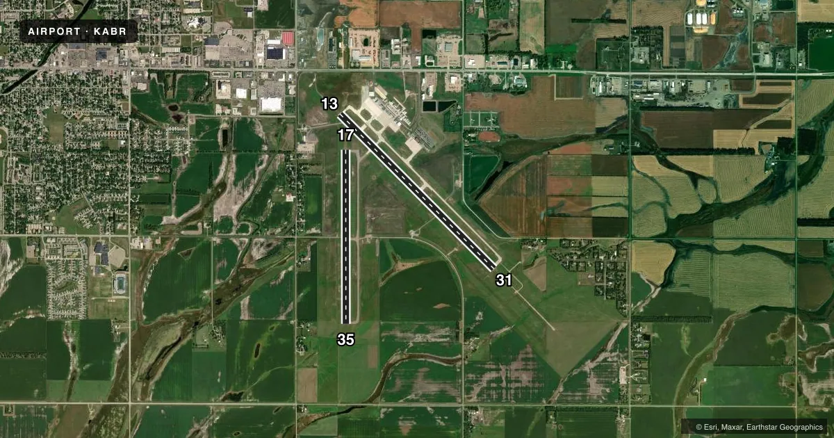
Runways & pattern
Full pagePattern entry · RWY 31
LEFT TRAFFIC| Runway | Heading (°M) | Length | Surface | Traffic |
|---|---|---|---|---|
| 13/31Favored | 128° / 308° | 6,901 ft | CONC | Standard L |
| 17/35 | 173° / 353° | 5,500 ft | ASPH | Standard L |
Runway end performance
| End | TORA | TODA | ASDA | LDA | VGSI | Approach lights | Obstruction |
|---|---|---|---|---|---|---|---|
| 13 | 6,901' | 6,901' | 6,901' | 6,901' | PAPI 4-box left(3°) | — | — |
| 31 | 6,901' | 6,901' | 6,901' | 6,901' | PAPI 4-box left(3°) | MALSR | — |
| 17 | 5,500' | 5,500' | 5,500' | 5,500' | PAPI 4-box right(3°) | — | — |
| 35 | 5,500' | 5,500' | 5,500' | 5,500' | PAPI 4-box left(3°) | — | — |
Declared distances in feet. TORA = takeoff run available, TODA = takeoff distance, ASDA = accelerate-stop, LDA = landing distance.
Airport sketch
Runways drawn to scale from FAA survey coordinates, rendered over satellite imagery. Not for navigation.
Approaches & charts
ILS · 1
Services on the field
Fuel grades, oxygen, maintenance, ramp storage and lighting — as declared to the FAA by the airport operator.
Fuel & services
- Fuel
- 100LLA
- Oxygen (bulk)
- High pressure
- Airframe repair
- Major
- Power plant repair
- Major
- Other services
- AFRT,AGRI,AMB,CHTR,INSTR,RNTL,SALES
Ramp & ground
- Transient storage
- Hangar
- Landing fee
- No fee published
- Customs
- Not available
- Lighting schedule
- SEE RMK
- Beacon schedule
- SS-SR
- Beacon
- White / Green (civil land)(WG)
- Wind indicator
- Lighted
- Segmented circle
- Yes
Fuel & FBOs
Cheapest 100LL and Jet A on the field and nearby. Always confirm with the FBO before taxi.
Airport notes
Surface conditions, obstructions, local procedures, lighting outages and other notes published with each FAA cycle.
General notes
- ARPT NOT AVBL FOR INTL ARRIVALS.
- SURFACE CONDITIONS NOT MONITORED 0000-0330L
- FOR CD IF UNA TO CTC ON FSS FREQ, CTC MINNEAPOLIS ARTCC AT 651-463-5588.
- BIRDS ON & INVOF ARPT.
Lighting notes
- ACTVT MALSR RWY 31; REIL RWYS 13, 17, & 35; & PAPI RWY 13/31,17/35 - CTAF; MIRL RWY 17/35 & HIRL RWY 13/31 PRESET ON LOW INTST SS-2400; TO INCR INTST USE CTAF.
Runway surface & condition
- 13/31PCR VALUE: 476/R/D/W/T
- 17/35PCR VALUE: 250/F/D/X/T
Other notes
- PPR FOR UNSKED ACR OPNS WITH MORE THAN 30 PSGR SEATS CALL AMGR 605-626-7020. AFT HRS CALL 605-216-0321.
- 2FOR SVCS AFTER HRS CALL (605) 225-1384/8008 OR (605)725-4774
VFR map & nearby airports
VFR sectional. Tap any ICAO chip to open that airport.
Key facts · KABR
Answer card- ICAO
- KABR
- Name
- ABERDEEN RGNL
- Location
- ABERDEEN, SOUTH DAKOTA
- Elevation
- 1,301.9 ft MSL
- Traffic pattern altitude
- 2,301.9 ft MSL (1,000 AGL)
- Control tower
- Non-towered (use CTAF)
- Total runways
- 2
- Longest runway
- 13/31 · 6,901 ft
- Published ILS approaches
- 1
- Published frequencies
- 2
- Magnetic variation
- 7°
- Current flight rules
- VFR
- Current wind
- 320° at 5 kt
- Favored runway now
- RWY 31
Aberdeen Rgnl sits in Aberdeen, South Dakota. Field elevation is 1,301.9 ft MSL. The airport has 2 runways. The longest is runway 13/31 at 6,901 ft. There is no control tower. CTAF and UNICOM are both 122.7. The published pattern altitude is not listed, so use the standard 1,000 ft AGL for light piston traffic unless the current Chart Supplement says otherwise.
Runway 31 has an ILS. That is the main precision option here. Runway 31 also has MALSR lighting. Runway 13/31 has high intensity runway lights. They are preset low from sunset to 2400. Use CTAF to increase intensity. Runway 17/35 has medium intensity lights. PAPI is published on both runway pairs. Runway end identifier lights are on 13, 17 and 35.
On the field, Quest Aviation carries 100LL, Jet A and Jet A Prist. Hangar 9 carries 100LL and Jet A Prist. Aberdeen Flying Service carries 100LL, Jet A and Jet A Prist. For after-hours service, the published remarks give direct phone numbers for Quest and Hangar 9. The airport also notes birds on and near the field. Surface conditions are not monitored from 0000 to 0330 local time. This is a non-towered airport, so plan your calls, spacing and runway selection with that in mind. If you need clearance delivery help, the published remarks point to Minneapolis ARTCC when FSS contact is not available.