METAR & TAF I64
I64 does not publish a METAR.
Showing the nearest reporting station: KLPR (LORAIN COUNTY RGNL) · 9.3 NM away. Conditions at I64 may differ.
METAR · KLPR
Observed 18:53Z
KLPR 271853Z AUTO 23010KT 10SM CLR 29/21 A2980 RMK AO2 SLP083 T02890211
- Wind
- 230° @ 10 kt
- Visibility
- 10 SM
- Temp / Dew
- 29°C / 21°C
- Altimeter
- 29.80 inHg
- Clouds
- CLR
- Density alt
- 2,880 ft
- Ceiling
- Unlimited
- Rules
- VFR
Airport info & contacts
Manager on record, flight service, ARTCC, attendance schedule and pattern altitude — published by the FAA and refreshed every 28 days.
Location
- From city
- 3 NM NE
- VFR sectional
- DETROIT
- ARTCC
- ZOB · CLEVELAND
- NOTAM facility
- CLE (NOTAM-D)
Airport manager
- Name
- COURTNEY ORTNER
- Phone
- 440-965-7787
- Address
- 9620 STATE ROUTE 60, WAKEMAN OH 44889-9236
Flight service · Hours
- FSS CLE
- CLEVELAND1-800-WX-BRIEF
- Attendance
- MON-SAT · 0800-DUSK
- SUN · 0900-1700
Frequencies
Tap any row to copy the frequency to your clipboard.
Runways & pattern
Full pagePattern entry · RWY 22
LEFT TRAFFICRunway end performance
| End | TORA | TODA | ASDA | LDA | VGSI | Approach lights | Obstruction |
|---|---|---|---|---|---|---|---|
| 04 | — | — | — | — | — | — | 82', trees, 735' from thr, 153' R of cntrln, slope 6 |
| 22 | — | — | — | — | — | — | 8', crops, 200' from thr, 7' R of cntrln, slope 0 |
Declared distances in feet. TORA = takeoff run available, TODA = takeoff distance, ASDA = accelerate-stop, LDA = landing distance.
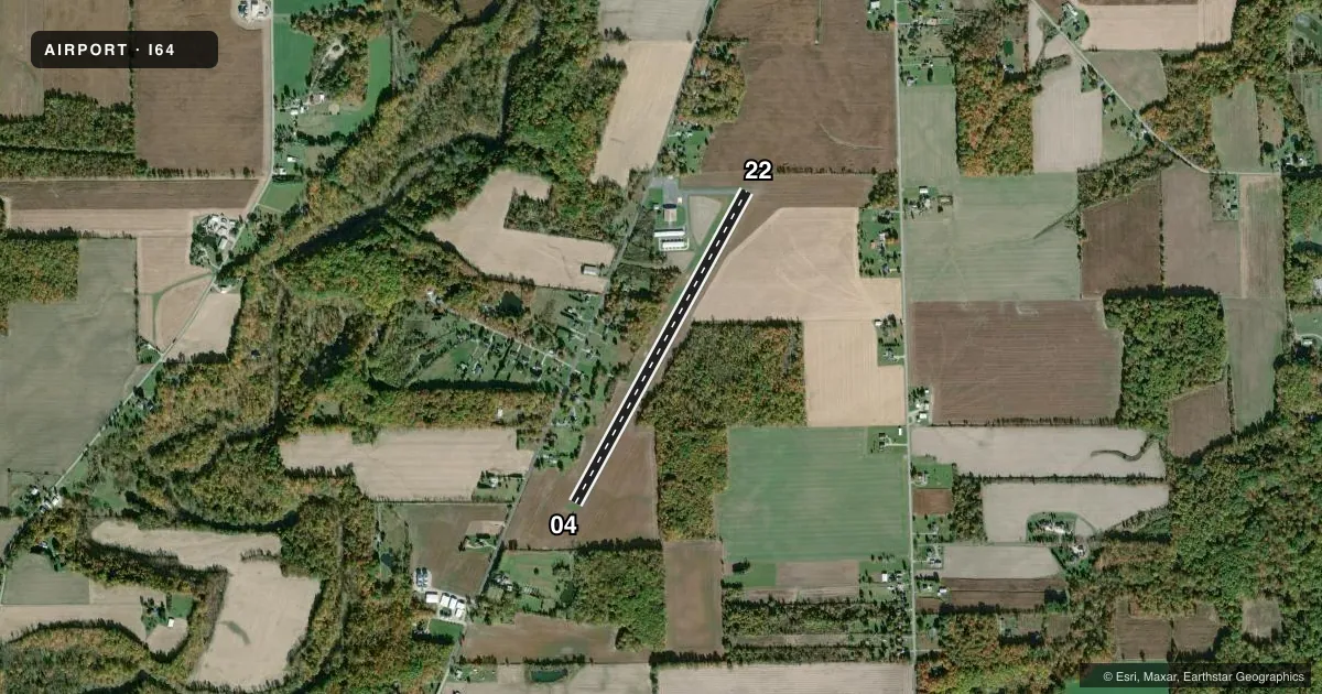
Airport sketch
Runways drawn to scale from FAA survey coordinates, rendered over satellite imagery. Not for navigation.
Approaches & charts
Services on the field
Fuel grades, oxygen, maintenance, ramp storage and lighting — as declared to the FAA by the airport operator.
Fuel & services
- Fuel
- 100LL
- Oxygen (bottled)
- Not available
- Oxygen (bulk)
- Not available
- Airframe repair
- Major
- Power plant repair
- Major
- Other services
- GLD,TOW
Ramp & ground
- Transient storage
- Hangar
- Landing fee
- No fee published
- Customs
- Not available
- Lighting schedule
- SEE RMK
- Wind indicator
- Yes
- Segmented circle
- No
Fuel & FBOs
Cheapest 100LL and Jet A on the field and nearby. Always confirm with the FBO before taxi.
Airport notes
Surface conditions, obstructions, local procedures, lighting outages and other notes published with each FAA cycle.
General notes
- DEER, BIRDS, & OTR WILDLIFE ON & INVOF ARPT.
- GLDR ACT ON & INVOF ARPT.
Lighting notes
- ACTVT NSTD LIRL RWY 04/22 - CTAF.
Runway surface & condition
- 04/22NSTD LIRL DUE TO LGTS 28 FT FM RWY EDGE; UNLGTD 134 FT FM AER 22.
Approach & departure obstructions
- 228 FT CROPS, 160-200 FT DIST, 55-125 FT R, OBSTN CLNC SLP 0:1.
- 04NSTD BASIC DUE TO RWY NR DSPLCD 338 FT FM THR.
- 22NSTD BASIC DUE TO RWY NR DSPLCD 210 FT FM THR.
- 04CTLG OBSTN EXCEEDS A 45 DEG SLP.
Other notes
- PRVDD OBSTNS IN APCH SFC ARE RMVD/LWRD, THRS DSPLCD TO PRVD 20:1 CLRNC, PRIM SFC CLRD/MAINTD.
- CALL AHD TO CK HNGR AVBL.
- MANAGEROTR 440-960-6911.
VFR map & nearby airports
VFR sectional. Tap any ICAO chip to open that airport.
Key facts · I64
Answer card- ICAO
- I64
- Name
- ORTNER
- Location
- WAKEMAN, OHIO
- Elevation
- 848 ft MSL
- Traffic pattern altitude
- 1,848 ft MSL (1,000 AGL)
- Control tower
- Non-towered (use CTAF)
- Total runways
- 1
- Longest runway
- 04/22 · 3,800 ft
- Published ILS approaches
- 0
- Published frequencies
- 2
- Magnetic variation
- 6°
- Current flight rules
- VFR
- Current wind
- 230° at 10 kt
- Favored runway now
- RWY 22
Ortner Airport (I64) is in Wakeman, Ohio. The field elevation is 848 ft MSL. It has one runway. Runway 04/22 is 3,800 ft long with asphalt and gravel surface. There is no control tower. CTAF and UNICOM are both 122.8. No ILS approaches are published here.
The published pattern altitude is not listed, so use the standard 1,000 ft AGL for light piston operations unless the current Chart Supplement says otherwise. Ortner Airport has one on-field FBO. Ortner Airport carries AVGAS 100LL. Call (440) 965-7787 before arrival if you need fuel or current field details.
Plan for local activity. Gliders operate on and near the airport. Deer, birds and other wildlife are also reported in the area. Runway 04/22 uses nonstandard low intensity lighting. Activate the lights by keying the common traffic advisory frequency. Runway 22 has a displaced number. The approach end is unlighted for part of the strip. There are also crop obstructions near runway 22. The runway 04 side has a cataloged obstruction that exceeds a 45 degree slope. Check the current Chart Supplement for any current operational notes before you go. Call the manager at 440-960-6911 if you need hangar or field information.