METAR & TAF PANC
Current METAR
Observed 23:53Z
PANC 272353Z 29010KT 10SM SCT034 BKN050 OVC080 14/10 A2992 RMK AO2 RAB09E18 SLP132 P0000 60002 T01390100 10156 20128 53013
- Wind
- 290° @ 10 kt
- Visibility
- 10 SM
- Temp / Dew
- 14°C / 10°C
- Altimeter
- 29.92 inHg
- Clouds
- OVC
- Density alt
- 68 ft
- Ceiling
- 5,000 ft AGL
- Rules
- VFR
Airport info & contacts
Manager on record, flight service, ARTCC, attendance schedule and pattern altitude — published by the FAA and refreshed every 28 days.
Location
- From city
- 4 NM SW
- VFR sectional
- ANCHORAGE
- ARTCC
- ZAN · ANCHORAGE
- NOTAM facility
- ANC (NOTAM-D)
Airport manager
- Name
- AARON DANIELSON
- Phone
- 907-266-2545
- Address
- BOX 196960, ANCHORAGE AK 99519-6960
Flight service · Hours
- FSS ENA
- KENAI907-283-72111-866-864-1737
- Attendance
- ALL
Frequencies
Tap any row to copy the frequency to your clipboard.
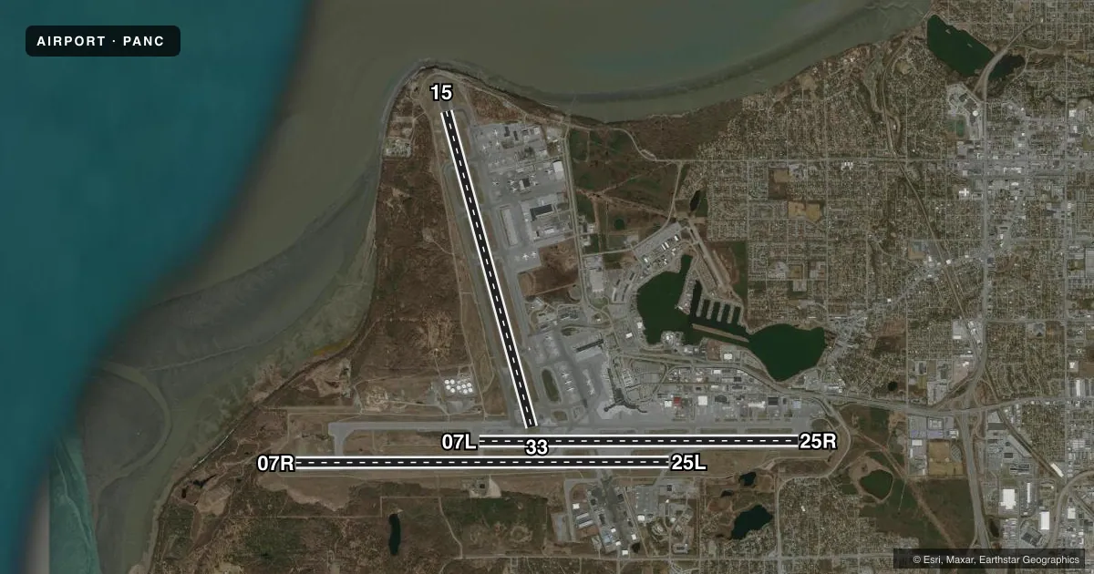
Runways & pattern
Full pagePattern entry · RWY 25L
LEFT TRAFFIC| Runway | Heading (°M) | Length | Surface | Traffic |
|---|---|---|---|---|
| 07R/25LFavored | 74° / 254° | 12,400 ft | ASPH-CONC | 07R R |
| 15/33 | 149° / 329° | 10,865 ft | ASPH | 15 R |
| 07L/25R | 74° / 254° | 10,600 ft | ASPH | 07L R |
Runway end performance
| End | TORA | TODA | ASDA | LDA | VGSI | Approach lights | Obstruction |
|---|---|---|---|---|---|---|---|
| 07R | 10,900' | 10,900' | 10,900' | 12,400' | PAPI 4-box right(3°) | ALSF2 | — |
| 25L | 12,400' | 12,400' | 12,000' | 12,000' | PAPI 4-box left(3°) | — | — |
| 15 | 10,865' | 10,865' | 10,000' | 10,000' | PAPI 4-box right(3.2°) | MALSF | — |
| 33 | 10,865' | 11,965' | 10,865' | 10,400' | PAPI 4-box right(3°) | — | — |
| 07L | 10,600' | 10,600' | 10,600' | 10,600' | PAPI 4-box right(3°) | MALSR | — |
| 25R | 10,600' | 10,600' | 10,600' | 10,600' | PAPI 4-box left(3°) | — | — |
Declared distances in feet. TORA = takeoff run available, TODA = takeoff distance, ASDA = accelerate-stop, LDA = landing distance.
Airport sketch
Runways drawn to scale from FAA survey coordinates, rendered over satellite imagery. Not for navigation.
Approaches & charts
ILS · 3
Services on the field
Fuel grades, oxygen, maintenance, ramp storage and lighting — as declared to the FAA by the airport operator.
Fuel & services
- Fuel
- 100100LLAA1
- Oxygen (bottled)
- HIGH/LOW
- Oxygen (bulk)
- HIGH/LOW
- Airframe repair
- Major
- Power plant repair
- Major
- Other services
- CARGO
Ramp & ground
- Transient storage
- Tie-down
- Hangar
- Landing fee
- Yes
- Customs
- Not available
- Beacon schedule
- SS-SR
- Beacon
- White / Green (civil land)(WG)
- Wind indicator
- Lighted
- Segmented circle
- No
Fuel & FBOs
Cheapest 100LL and Jet A on the field and nearby. Always confirm with the FBO before taxi.
Airport notes
Surface conditions, obstructions, local procedures, lighting outages and other notes published with each FAA cycle.
General notes
- BIRDS INVOF ARPT SPRING - FALL.
- NON-RADIO NIGHT OPS NA; NON-PARROT OPS 1 HR PPR; NON-RADIO OPS PPR; MUST PRVD ETA & REMAIN WI 15 MIN - ATCT 907-271-2700 WKDAYS 0730-1600; AFT HR & HOL - FAA 907-271-5936.
- WSO - 907-266-5105.
- 489 FT UNLGTD TWR 2.5 MI NE.
- PTNS OF TWY K BTN TWY H & J NOT VIS FM ATCT.
- COMPASS CLBR PAD N/A.
- R TURN OUT OF RAMP PRKG R-2 THRU R-4 NA.
- FLT PLANNING IN ANCHORAGE BOWL AREA - RCO 122.55.
- FAA RAMP PPR WITH ANC FIFO MON-FRI 0600-1430 - 135.85 OR 907-271-2414 OR AVN 405-954-9780.
- ANCHORAGE WX CAMERA AVBL ON INTERNET AT HTTPS://WEATHERCAMS.FAA.GOV.
- TWY V RSTRD TO 12500 LB OR LESS; SUBJECT TO JET BLAST W OF TWY E.
- TSNT MIL PPR.
- NOISE SENSITIVE AREA S & E; RWY 07R, 07L, 15 TBJT/TURBOFAN DEP EMPLOY FAA CLOSE IN NADP OR ICAO PROC B NADP WHEN SAFETY PERMITS; INFO - AMGR.
- TWY V, SCTY GATE E OF TWY E - PCL 121.75 5 TIMES; TWY H-2, LAKESHORE TWY GATES - PCL 121.75 3 TIMES; IF INOP ALLOW 30 SEC RESET & NOTIFY LHD OPS - 907-266-2600.
- PPR FOR GND TIME GTR THAN 4 HR AT ARPT CTL SPOTS; APVL REQ 48 HR PRIOR TO DEP FOR ANC - GATE MGMT 907 266-2633 OR EMAIL: DOT.AIA.OPS.GATEMANAGEMENT@ALASKA.GOV.
- P RAMP PRKG SPOTS P1/2/3 JET BLAST HAZ; EXIT USING MIN THRUST REQ.
- COLD TEMPERATURE AIRPORT. ALTITUDE CORRECTION REQUIRED AT OR BELOW -21C.
Runway surface & condition
- 07L/25RPCR VALUE: 663/F/A/W/T
- 07R/25LPCR VALUE: 663/F/A/W/T
- 15/33PCR VALUE: 663/F/A/W/T
Approach & departure obstructions
- 07RBACK TAX FM TWY J FOR DEP NA.
- 25L200 FT BLAST PAD.
VFR map & nearby airports
VFR sectional. Tap any ICAO chip to open that airport.
Key facts · PANC
Answer card- ICAO
- PANC
- Name
- TED STEVENS ANCHORAGE INTL
- Location
- ANCHORAGE, ALASKA
- Elevation
- 151.4 ft MSL
- Traffic pattern altitude
- 1,151.4 ft MSL (1,000 AGL)
- Control tower
- Towered · 24
- Total runways
- 3
- Longest runway
- 07R/25L · 12,400 ft
- Published ILS approaches
- 3
- Published frequencies
- 36
- Magnetic variation
- 16°
- Current flight rules
- VFR
- Current wind
- 290° at 10 kt
- Favored runway now
- RWY 25L
Ted Stevens Anchorage Intl is in Anchorage, Alaska. Field elevation is 151.4 ft MSL. The airport has three runways. The longest is 12,400 ft on 07R/25L. The tower is open 24 hours. Three ILS approaches are published for runway ends 07L, 07R and 15.
Pattern altitude is not published. Use 1,000 ft AGL for light piston traffic unless ATC gives you something different. The airport sits in the Anchorage bowl, so plan for busy Class C operations and stay sharp on taxi instructions. Flight planning in the bowl also uses remote communications outlet frequency 122.55. Noise-sensitive areas are south and east. Turbojet and turbofan departures on 07R, 07L and 15 use close-in noise abatement procedures when safety permits.
On field FBOs include Great Circle Flight Services with JET A and JET A Prist. International Aviation Services carries 100LL, JET A and JET A Prist. Signature Aviation carries JET A. Atlantic Aviation carries JET A and JET A Prist. Taxiway V is restricted to 12,500 pounds or less. Some taxiway and gate areas have jet blast hazards. Portions of taxiway K between H and J are not visible from the tower. There is also a 489 ft unlighted tower 2.5 miles northeast, so keep that in mind on arrival and departure.