METAR & TAF PAMR
Current METAR
Observed 20:53Z
PAMR 272053Z 36003KT 10SM FEW015 SCT040 OVC085 15/12 A2988 RMK AO2 RAB02E45 SLP118 P0000 60001 T01500117 53009
- Wind
- 360° @ 3 kt
- Visibility
- 10 SM
- Temp / Dew
- 15°C / 12°C
- Altimeter
- 29.88 inHg
- Clouds
- OVC
- Density alt
- 227 ft
- Ceiling
- 8,500 ft AGL
- Rules
- VFR
Airport info & contacts
Manager on record, flight service, ARTCC, attendance schedule and pattern altitude — published by the FAA and refreshed every 28 days.
Location
- From city
- 2 NM E
- VFR sectional
- ANCHORAGE
- ARTCC
- ZAN · ANCHORAGE
- NOTAM facility
- MRI (NOTAM-D)
Airport manager
- Name
- EARL MALPASS
- Phone
- 907-343-6301
- Address
- 800 MERRIL FIELD DR, ANCHORAGE AK 99501-4129
Flight service · Hours
- FSS ENA
- KENAI907-283-72111-866-864-1737
- Attendance
- MON-FRI · 0730-1730
Frequencies
Tap any row to copy the frequency to your clipboard.
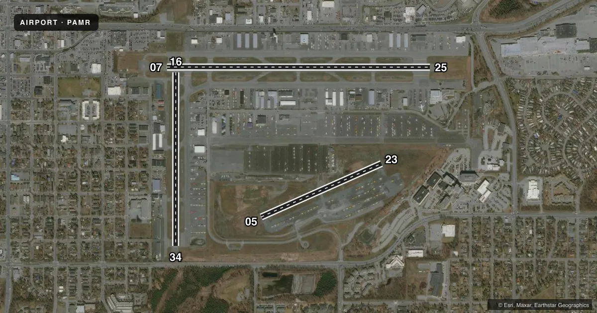
Runways & pattern
Full pagePattern entry · RWY 34
LEFT TRAFFIC| Runway | Heading (°M) | Length | Surface | Traffic |
|---|---|---|---|---|
| 07/25 | 71° / 251° | 4,000 ft | ASPH | 07 R |
| 16/34Favored | 161° / 341° | 2,640 ft | ASPH | 16 R |
| 05/23 | 47° / 227° | 2,000 ft | ASPH-GRVL | Standard L |
Runway end performance
| End | TORA | TODA | ASDA | LDA | VGSI | Approach lights | Obstruction |
|---|---|---|---|---|---|---|---|
| 07 | — | — | — | — | PAPI 4-box right(3.5°) | — | 41', pole, 846' from thr, 339' R of cntrln, slope 15 |
| 25 | — | — | — | — | PAPI 4-box left(3°) | — | — |
| 16 | — | — | — | — | VASI 2-box right(3°) | — | 31', bldg, 437' from thr, 268' R of cntrln, slope 7 |
| 34 | — | — | — | — | PAPI 2-box left(3°) | — | 27', pole, 331' from thr, 231' R of cntrln, slope 4 |
| 23 | — | — | — | — | — | — | 7', fence, 250' from thr, 115' R of cntrln, slope 7 |
Declared distances in feet. TORA = takeoff run available, TODA = takeoff distance, ASDA = accelerate-stop, LDA = landing distance.
Airport sketch
Runways drawn to scale from FAA survey coordinates, rendered over satellite imagery. Not for navigation.
Approaches & charts
Services on the field
Fuel grades, oxygen, maintenance, ramp storage and lighting — as declared to the FAA by the airport operator.
Fuel & services
- Fuel
- 100A
- Oxygen (bottled)
- Low pressure
- Oxygen (bulk)
- Low pressure
- Airframe repair
- Major
- Power plant repair
- Major
- Other services
- AFRT,AMB,AVNCS,CARGO,CHTR,INSTR,RNTL,SALES,SURV
Ramp & ground
- Transient storage
- Tie-down
- Hangar
- Landing fee
- No fee published
- Customs
- Not available
- Lighting schedule
- SEE RMK
- Beacon schedule
- SS-SR
- Beacon
- White / Green (civil land)(WG)
- Wind indicator
- Lighted
- Segmented circle
- No
Fuel & FBOs
Cheapest 100LL and Jet A on the field and nearby. Always confirm with the FBO before taxi.
Airport notes
Surface conditions, obstructions, local procedures, lighting outages and other notes published with each FAA cycle.
General notes
- BIRDS & SEAGULLS ON & INVOF ARPT.
- PPR OVR 12500 LB.
- ALL RWY & TWY LGTS NONSTD HEIGHT.
- 1-8 FT SNOW BERMS ADJ TO RWYS & TWYS DURG WINTER.
- WHEN ATCT CLSD CTC MERRILL WX - CTAF OR 271-4355.
- FLT PLANNING IN ANCHORAGE BOWL AREA - RCO 122.55.
- NONMOVEMENT AREA ACFT CTC GND CTL BFR TAX.
- ANCHORAGE WX CAMERA AVBL ON INTERNET AT HTTPS://WEATHERCAMS.FAA.GOV
- PTNS OF TWY C BTN TWY S & N AND PTNS OF TWY Q NOT VIS FM TWR.
- TWY B SOUTH OF TWY M, TWY G BTN TWY N & RWY 05/23, TWY Q EAST OF TWY C & ALL SFCS SOUTH OF RWY 05/23 UNCTLD.
- COMPASS ROSE AVBL WITH PRIOR CDN - ATCT.
- ARR/DEP ROUTES - SEE AREA NOTICES; SPL NOTICE CARTEE ASP.
- NOISE ABATEMENT; TGL OR PAT WORK NA 2200-0700.
- ALASKA RGNL HOSPITAL 2OK HELI ON ARPT; SEE SEPARATE LISTING FOR INFO.
- OTFC OF ARPT BLO 300 FT NA.
Lighting notes
- ACTVT REIL RWY 07, 16, 25, 34; MIRL RWY 07/25 & 16/34 - CTAF. PAPI RWY 07, 25 & 34; VASI RWY 16 OPR CONSLY.
Runway surface & condition
- 05/23USED SEASONALLY AS SNOW RWY. RCMD SKI EQUIP ACFT USE TO MINIMIZE WHEEL RUTTING.
Other notes
- TPA FOR ACFT 105 KTS OR LESS 900 FT MSL. ACFT GREATER THAN 105 KTS 1200 FT MSL.
- 05/23FIRST 60 FT PAVED; RMNG GRVL.
VFR map & nearby airports
VFR sectional. Tap any ICAO chip to open that airport.
Key facts · PAMR
Answer card- ICAO
- PAMR
- Name
- MERRILL FLD
- Location
- ANCHORAGE, ALASKA
- Elevation
- 143.1 ft MSL
- Traffic pattern altitude
- 1,143.1 ft MSL (1,000 AGL)
- Control tower
- Towered · 0700-2200L.
- Total runways
- 3
- Longest runway
- 07/25 · 4,000 ft
- Published ILS approaches
- 0
- Published frequencies
- 10
- Magnetic variation
- 19°
- Current flight rules
- VFR
- Current wind
- 360° at 3 kt
- Favored runway now
- RWY 34
Merrill Field sits in Anchorage, Alaska. Field elevation is 143.1 ft MSL. The airport has three runways. The longest is runway 07/25 at 4,000 ft. The tower is open 0700-2200L. No ILS approaches are published here, so plan with the current chart and weather brief. Pattern altitude is not published. Use the standard 1,000 ft AGL for light piston aircraft unless local procedures say otherwise.
This is an active Anchorage field with Class C procedures on the published frequencies. The airport sits in the Anchorage bowl, so expect busy local traffic and follow the area notices for arrival and departure routing. The published remarks also say obstacle clearance below 300 ft is not authorized. That matters on short final and in the climb out. Runway lighting is available on 07/25 and 16/34. PAPI is published on 07, 25 and 34. VASI is published on 16.
Crowley Aviation Fuels is on the field. It carries 100LL and Jet A. Spernak Airways is also on the field. It carries 100LL. Runway 05/23 has a paved first 60 ft. The rest is gravel. Winter operations can include snow berms near runways and taxiways. When the tower is closed, contact Merrill weather on CTAF or by phone before taxi. Noise abatement prohibits touch-and-go or pattern work between 2200 and 0700.