METAR & TAF Z40
Z40 does not publish a METAR.
Showing the nearest reporting station: PABV (BIRCHWOOD) · 9.7 NM away. Conditions at Z40 may differ.
METAR · PABV
Observed 20:56Z
PABV 272056Z AUTO 03005KT 10SM BKN050 OVC070 14/12 A2988 RMK AO2 SLP118 T01440122 51009 $
- Wind
- 030° @ 5 kt
- Visibility
- 10 SM
- Temp / Dew
- 14°C / 12°C
- Altimeter
- 29.88 inHg
- Clouds
- OVC
- Density alt
- 26 ft
- Ceiling
- 5,000 ft AGL
- Rules
- VFR
Airport info & contacts
Manager on record, flight service, ARTCC, attendance schedule and pattern altitude — published by the FAA and refreshed every 28 days.
Location
- From city
- 0 NM E
- VFR sectional
- ANCHORAGE
- ARTCC
- ZAN · ANCHORAGE
- NOTAM facility
- ENA (NOTAM-D)
Airport manager
- Name
- KYLER HYLTON
- Phone
- 907-246-3325
- Address
- 289 INNER SPRINGER LOOP RD., PALMER AK 99645
Flight service · Hours
- FSS ENA
- KENAI907-283-72111-866-864-1737
- Attendance
- Unattended
Frequencies
Tap any row to copy the frequency to your clipboard.
Runways & pattern
Full pagePattern entry · RWY 08
RIGHT TRAFFICRunway end performance
| End | TORA | TODA | ASDA | LDA | VGSI | Approach lights | Obstruction |
|---|---|---|---|---|---|---|---|
| 08 | — | — | — | — | — | — | 15', road, 0' from thr, 80' R of cntrln, slope 0 |
| 26 | — | — | — | — | — | — | 15', road, 0' from thr, 80' R of cntrln, slope 0 |
Declared distances in feet. TORA = takeoff run available, TODA = takeoff distance, ASDA = accelerate-stop, LDA = landing distance.
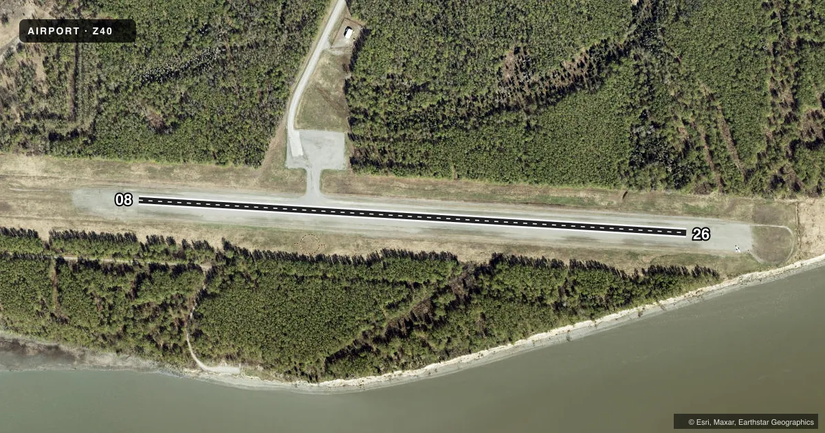
Airport sketch
Runways drawn to scale from FAA survey coordinates, rendered over satellite imagery. Not for navigation.
Approaches & charts
Services on the field
Fuel grades, oxygen, maintenance, ramp storage and lighting — as declared to the FAA by the airport operator.
Fuel & services
- Fuel
- Not available
Ramp & ground
- Transient storage
- Not published
- Landing fee
- No fee published
- Customs
- Not available
- Wind indicator
- Yes
- Segmented circle
- Yes
Fuel & FBOs
Cheapest 100LL and Jet A on the field and nearby. Always confirm with the FBO before taxi.
Airport notes
Surface conditions, obstructions, local procedures, lighting outages and other notes published with each FAA cycle.
General notes
- RWY COND UNMNTD; RCMD VISUAL INSP BFR USE.
- 808 FT LGTD TWR 11700 FT NNW OF RWY.
- WX CAMERA AVBL ON INTERNET AT HTTPS://WEATHERCAMS.FAA.GOV
- LRG MIL LOW ALT OPS INVOF R-2203, GOOSE BAY, BIRCHWOOD & BIG LAKE ARPTS. MIL ACFT MNT MULT CTAF FREQ. SEE CURRENT ANCHORAGE VFR TAC INSERT & CNTR NOTAMS.
Approach & departure obstructions
- 08RWY END THR PANEL.
- 26RWY END THR PANEL.
VFR map & nearby airports
VFR sectional. Tap any ICAO chip to open that airport.
Key facts · Z40
Answer card- ICAO
- Z40
- Name
- GOOSE BAY
- Location
- GOOSE BAY, ALASKA
- Elevation
- 78 ft MSL
- Traffic pattern altitude
- 1,078 ft MSL (1,000 AGL)
- Control tower
- Non-towered (use CTAF)
- Total runways
- 1
- Longest runway
- 08/26 · 3,000 ft
- Published ILS approaches
- 0
- Published frequencies
- 1
- Magnetic variation
- 25°
- Current flight rules
- VFR
- Current wind
- 030° at 5 kt
- Favored runway now
- RWY 08
Goose Bay Airport (Z40) is in Goose Bay, Alaska. The field elevation is 78 ft MSL. It has one runway. The longest is 08/26 at 3,000 ft on gravel. No tower is published, so plan for CTAF self-announce work on 122.9.
No ILS approaches are published here. Pattern altitude is not published in the facts. Verify the current Chart Supplement before you fly. The runway end has threshold panels on both ends. Runway condition is unmonitored, so a visual inspection before use is a good idea. There is also an 808-foot lighted tower 11,700 feet north-northwest of the runway. That matters on arrival and departure planning.
No on-field FBOs are listed in the facts. Check with the airport operator or the field directly by phone before arrival if you need fuel or other services. Large military low altitude operations are reported in the area near R-2203, Goose Bay, Birchwood and Big Lake airports. Military aircraft may be on multiple CTAF frequencies. Use the current Anchorage VFR TAC insert and center NOTAMs for the latest picture before you go.