METAR & TAF PAGQ
PAGQ does not publish a METAR.
Showing the nearest reporting station: PAWS (WASILLA) · 8.1 NM away. Conditions at PAGQ may differ.
METAR · PAWS
Observed 23:26Z
PAWS 272326Z AUTO 00000KT 10SM -RA FEW004 OVC065 13/13 A2994 RMK AO2 P0001 $
- Wind
- 000° @ 0 kt
- Visibility
- 10 SM
- Temp / Dew
- 13°C / 13°C
- Altimeter
- 29.94 inHg
- Clouds
- OVC
- Density alt
- -63 ft
- Ceiling
- 6,500 ft AGL
- Rules
- VFR
Airport info & contacts
Manager on record, flight service, ARTCC, attendance schedule and pattern altitude — published by the FAA and refreshed every 28 days.
Location
- From city
- 1 NM SE
- VFR sectional
- ANCHORAGE
- ARTCC
- ZAN · ANCHORAGE
- NOTAM facility
- ENA (NOTAM-D)
Airport manager
- Name
- KYLER HYLTON
- Phone
- 907-745-2159
- Address
- 289 INNER SPRING LOOP, DOT&PF CENTRAL REGION, PALMER AK 99645
Flight service · Hours
- FSS ENA
- KENAI907-283-72111-866-864-1737
- Attendance
- Unattended
Frequencies
Tap any row to copy the frequency to your clipboard.
Runways & pattern
Full pagePattern entry · RWY 07
LEFT TRAFFICRunway end performance
| End | TORA | TODA | ASDA | LDA | VGSI | Approach lights | Obstruction |
|---|---|---|---|---|---|---|---|
| 07 | — | — | — | — | — | — | 60', trees, 0' from thr, 200' R of cntrln, slope 0 |
| 25 | — | — | — | — | — | — | 50', trees, 0' from thr, 207' R of cntrln, slope 0 |
Declared distances in feet. TORA = takeoff run available, TODA = takeoff distance, ASDA = accelerate-stop, LDA = landing distance.
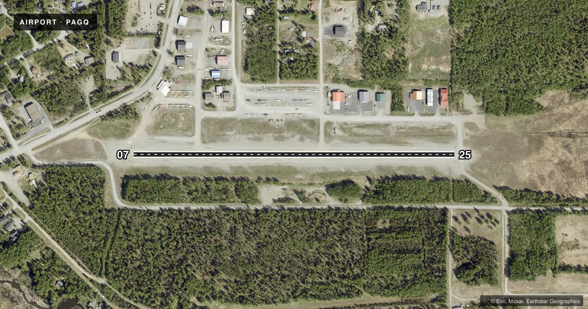
Airport sketch
Runways drawn to scale from FAA survey coordinates, rendered over satellite imagery. Not for navigation.
Approaches & charts
Services on the field
Fuel grades, oxygen, maintenance, ramp storage and lighting — as declared to the FAA by the airport operator.
Fuel & services
- Fuel
- Not available
- Airframe repair
- Major
- Power plant repair
- Major
Ramp & ground
- Transient storage
- Tie-down
- Lighting schedule
- SEE RMK
- Beacon schedule
- SS-SR
- Beacon
- White / Green (civil land)(WG)
- Wind indicator
- Lighted
- Segmented circle
- Yes
Fuel & FBOs
Cheapest 100LL and Jet A on the field and nearby. Always confirm with the FBO before taxi.
Airport notes
Surface conditions, obstructions, local procedures, lighting outages and other notes published with each FAA cycle.
General notes
- LOW FLYING ACFT INVOF APCH TO BIG LAKE VOR.
- RY COND NOT MONITORED; RECOMMEND VISUAL INSPECTION PRIOR TO USE.
- UPDRAFT OFF OF RISING HILL ON APCH TO RY 25.
- RY 07+15' ROAD PARALLEL TO RY END.
- 190 FT AGL LIGHTED TWR 2 NM NE OF ARPT.
- BE ALERT: OCCASIONAL ULTRA LIGHT TRAFFIC.
- ARPT HAS DESIGNATED TRANSIENT ACFT PARKING AVBL. TRANSIENT ACFT PARKING IS DESIGNATED WITH GREEN CONES.
- BE ALERT: FROST HEAVE ON RY APRXLY 2200 FT.
Lighting notes
- ACTVT MIRL RY 07/25 - 122.8
VFR map & nearby airports
VFR sectional. Tap any ICAO chip to open that airport.
Key facts · PAGQ
Answer card- ICAO
- PAGQ
- Name
- BIG LAKE
- Location
- BIG LAKE, ALASKA
- Elevation
- 162.4 ft MSL
- Traffic pattern altitude
- 1,162.4 ft MSL (1,000 AGL)
- Control tower
- Non-towered (use CTAF)
- Total runways
- 1
- Longest runway
- 07/25 · 2,450 ft
- Published ILS approaches
- 0
- Published frequencies
- 3
- Magnetic variation
- 15°
- Current flight rules
- VFR
- Current wind
- 000° at 0 kt
- Favored runway now
- –
Big Lake Airport (PAGQ) sits in Big Lake, Alaska. Field elevation is 162.4 ft MSL. The airport has one runway. Runway 07/25 is 2,450 ft long and gravel. The longest runway is 2,450 ft.
There is no control tower. CTAF is 122.8. The published approach and departure frequency is 118.6 for Anchorage. No ILS approaches are published here. Pattern altitude is not published, so use the standard 1,000 ft AGL for light piston traffic unless the current Chart Supplement says otherwise. The field also has medium intensity runway lighting on runway 07/25. It is activated on 122.8.
No on-field FBOs are listed. Transient aircraft parking is available. Look for the green cones. Published remarks call out an updraft off the rising hill on approach to runway 25. They also note a 190 ft AGL lighted tower 2 NM northeast of the airport. Watch for frost heave on the runway. Runway condition is not monitored, so a visual inspection before use is smart. There is also a 15-foot wide road parallel to the end of runway 07. Expect occasional ultralight traffic. Low flying aircraft are in the vicinity of the approach to Big Lake VOR.