METAR & TAF PABV
Current METAR
Observed 21:56Z
PABV 272156Z AUTO 06005KT 10SM -RA OVC070 14/12 A2990 RMK AO2 RAB09E25B52 SLP123 P0000 T01440117 $
- Wind
- 060° @ 5 kt
- Visibility
- 10 SM
- Temp / Dew
- 14°C / 12°C
- Altimeter
- 29.90 inHg
- Clouds
- OVC
- Density alt
- 8 ft
- Ceiling
- 7,000 ft AGL
- Rules
- VFR
Airport info & contacts
Manager on record, flight service, ARTCC, attendance schedule and pattern altitude — published by the FAA and refreshed every 28 days.
Location
- From city
- 2 NM NW
- VFR sectional
- ANCHORAGE
- ARTCC
- ZAN · ANCHORAGE
- NOTAM facility
- BCV (NOTAM-D)
Airport manager
- Name
- KAYCE ELIASON
- Phone
- 907-338-1466
- Address
- 5300 E. TUDOR ROAD, STATE OF ALASKA DOTPF CR, ANCHORAGE AK 99507-1249
Flight service · Hours
- FSS ENA
- KENAI907-283-72111-866-864-1737
- Attendance
- Unattended
Frequencies
Tap any row to copy the frequency to your clipboard.
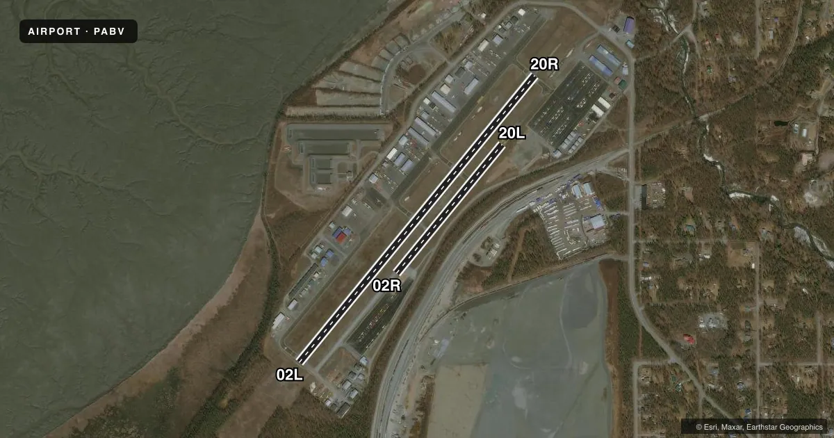
Runways & pattern
Full pagePattern entry · RWY 02L
LEFT TRAFFIC| Runway | Heading (°M) | Length | Surface | Traffic |
|---|---|---|---|---|
| 02L/20RFavored | 20° / 200° | 4,012 ft | ASPH | 20R R |
| 02R/20L | 20° / 200° | 1,802 ft | ASPH-GRVL | 20L R |
Runway end performance
| End | TORA | TODA | ASDA | LDA | VGSI | Approach lights | Obstruction |
|---|---|---|---|---|---|---|---|
| 02L | — | — | — | — | — | — | 71', trees, 613' from thr, 283' R of cntrln, slope 5 |
| 20R | — | — | — | — | VASI 4-box left | — | 44', trees, 980' from thr, 308' R of cntrln, slope 18 |
Declared distances in feet. TORA = takeoff run available, TODA = takeoff distance, ASDA = accelerate-stop, LDA = landing distance.
Airport sketch
Runways drawn to scale from FAA survey coordinates, rendered over satellite imagery. Not for navigation.
Approaches & charts
Services on the field
Fuel grades, oxygen, maintenance, ramp storage and lighting — as declared to the FAA by the airport operator.
Fuel & services
- Fuel
- 100LL
- Airframe repair
- Major
- Power plant repair
- Major
- Other services
- CHTR,GLD,INSTR,RNTL
Ramp & ground
- Transient storage
- Tie-down
- Hangar
- Lighting schedule
- SEE RMK
- Beacon schedule
- SS-SR
- Beacon
- White / Green (civil land)(WG)
- Wind indicator
- Lighted
- Segmented circle
- Yes
Fuel & FBOs
Cheapest 100LL and Jet A on the field and nearby. Always confirm with the FBO before taxi.
Airport notes
Surface conditions, obstructions, local procedures, lighting outages and other notes published with each FAA cycle.
General notes
- CTN: SAILPLANE OPS.
- MID 1500 FT TWY A DSGND ULTRALIGHT & SKI/TUNDRA TIRE EQUIP RWY; PARL OPS NA - SEQ ON CTAF.
- TSNT PRKG AVBL; FEE AFT 24 HR.
- HEL AVOID FIXED WING & ULTRALIGHT TFC PAT.
- WX CAMERA AVBL ON INTERNET AT HTTPS://WEATHERCAMS.FAA.GOV
- WINTER MAINT NA.
- RWY COND UNMNT; RCMND VIS INSPN BFR LNDG.
Lighting notes
- ACTVT VASI RWY 20R; MIRL RWY 02L/20R - CTAF. ACTVT VASI RWY 20R - 7 CLICKS.
Runway surface & condition
- 02R/20LSKI/TUNDRA TIRE RWY.
- 02R/20L600 FT ASPH RWY 20L END; RMNDR GRVL.
Approach & departure obstructions
- 02LROAD 10 FT FM THR ACRS CNTRLN.
- 20LEXC ULTRALIGHT; USE L TFC E AWAY FM RWYS.
- 20REXC ULTRALIGHT; USE L TFC E AWAY FM RWYS.
- 02LCTLG OBS EXCEEDS 45 DEG SLP.
Other notes
- 02L/20RHUMPS & RUTS.
- 02R/20LHUMPS & RUTS.
VFR map & nearby airports
VFR sectional. Tap any ICAO chip to open that airport.
Key facts · PABV
Answer card- ICAO
- PABV
- Name
- BIRCHWOOD
- Location
- BIRCHWOOD, ALASKA
- Elevation
- 83 ft MSL
- Traffic pattern altitude
- 1,083 ft MSL (1,000 AGL)
- Control tower
- Non-towered (use CTAF)
- Total runways
- 2
- Longest runway
- 02L/20R · 4,012 ft
- Published ILS approaches
- 0
- Published frequencies
- 1
- Magnetic variation
- 19°
- Current flight rules
- VFR
- Current wind
- 060° at 5 kt
- Favored runway now
- RWY 02L
Birchwood Airport sits in Birchwood, Alaska at 83 ft MSL. It has two runways. The longest is 02L/20R at 4,012 ft. The other runway is 02R/20L at 1,802 ft. There is no control tower. CTAF is 123.0. No ILS approaches are published.
The published pattern altitude is not listed. For planning, use the current Chart Supplement and local traffic calls. C2 Aviation is on the field. It carries AVGAS 100LL. Call (907) 444-8844 for current service details.
This is a field where the remarks matter. Runway 02R/20L has humps and ruts. The runway is also split between asphalt and gravel. The 600 ft asphalt segment is on 20L. The rest is gravel. Runway condition is unmonitored. A visual inspection before landing is recommended. Winter maintenance is not available. There are also sailplane operations, so keep a sharp scan in the pattern and on taxi. Helicopters should avoid fixed-wing and ultralight traffic patterns. Taxiway A has a middle 1,500 ft segment set aside for ultralight and ski or tundra tire runway operations. Parallel operations are not authorized there. For runway 20R, the visual approach slope indicator is activated by 7 clicks. Medium intensity runway lights are on 02L/20R and controlled by CTAF.