METAR & TAF 5HO
5HO does not publish a METAR.
Showing the nearest reporting station: PANC (TED STEVENS ANCHORAGE INTL) · 19.4 NM away. Conditions at 5HO may differ.
METAR · PANC
Observed 14:53Z
PANC 271453Z 16009KT 10SM -RA FEW030 FEW050 BKN070 OVC130 13/11 A2984
- Wind
- 160° @ 9 kt
- Visibility
- 10 SM
- Temp / Dew
- 13°C / 11°C
- Altimeter
- 29.84 inHg
- Clouds
- OVC
- Density alt
- 100 ft
- Ceiling
- 7,000 ft AGL
- Rules
- VFR
Airport info & contacts
Manager on record, flight service, ARTCC, attendance schedule and pattern altitude — published by the FAA and refreshed every 28 days.
Location
- From city
- 1 NM SE
- VFR sectional
- ANCHORAGE
- ARTCC
- ZAN · ANCHORAGE
- NOTAM facility
- ENA (NOTAM-D)
Airport manager
- Name
- ROB SMITH
- Phone
- 907-288-2428
- Address
- STATE OF AK - DOTPF, 35200 HOPE HWY, HOPE AK 99605
Flight service · Hours
- FSS ENA
- KENAI907-283-72111-866-864-1737
- Attendance
- Unattended
Frequencies
Tap any row to copy the frequency to your clipboard.
Runways & pattern
Full pagePattern entry · RWY 17
LEFT TRAFFICRunway end performance
| End | TORA | TODA | ASDA | LDA | VGSI | Approach lights | Obstruction |
|---|---|---|---|---|---|---|---|
| 17 | — | — | — | — | — | — | 57', trees, 0' from thr, 110' R of cntrln, slope 0 |
| 35 | — | — | — | — | — | — | 53', trees, 0' from thr, 110' R of cntrln, slope 0 |
Declared distances in feet. TORA = takeoff run available, TODA = takeoff distance, ASDA = accelerate-stop, LDA = landing distance.
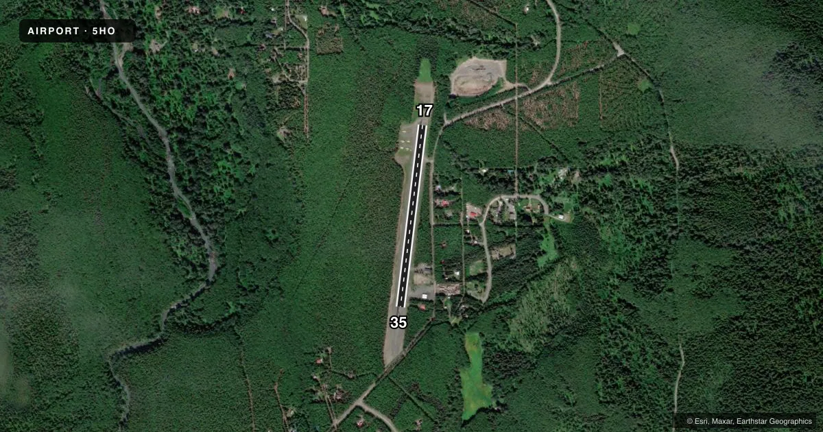
Airport sketch
Runways drawn to scale from FAA survey coordinates, rendered over satellite imagery. Not for navigation.
Approaches & charts
Services on the field
Fuel grades, oxygen, maintenance, ramp storage and lighting — as declared to the FAA by the airport operator.
Fuel & services
- Fuel
- Not available
- Oxygen (bottled)
- Not available
- Oxygen (bulk)
- Not available
- Airframe repair
- Not available
- Power plant repair
- Not available
Ramp & ground
- Transient storage
- Not published
- Landing fee
- No fee published
- Customs
- Not available
- Wind indicator
- Yes
- Segmented circle
- Yes
Fuel & FBOs
Cheapest 100LL and Jet A on the field and nearby. Always confirm with the FBO before taxi.
Airport notes
Surface conditions, obstructions, local procedures, lighting outages and other notes published with each FAA cycle.
General notes
- BE ALERT RWY CONDITION NOT MONITORED. RECOMMEND VISUAL INSPECTION PRIOR TO LANDING.
- SAFETY AREA NORTH END CLEARED 470 FT, SAFETY AREA SOUTH END CLEARED 580 FT.
Approach & departure obstructions
- 17NSTD MKGS RYS 17 & 35; RWY THLDS MKD WITH PLASTIC MARKERS.
Other notes
- ESTABD PRIOR TO 1959.
- WINDSOCKS LOCATED AT BOTH ENDS OF RWY 17/35.
- MANAGERALT PH: 907-262-1187.
VFR map & nearby airports
VFR sectional. Tap any ICAO chip to open that airport.
Key facts · 5HO
Answer card- ICAO
- 5HO
- Name
- HOPE
- Location
- HOPE, ALASKA
- Elevation
- 193.9 ft MSL
- Traffic pattern altitude
- 1,193.9 ft MSL (1,000 AGL)
- Control tower
- Non-towered (use CTAF)
- Total runways
- 1
- Longest runway
- 17/35 · 2,040 ft
- Published ILS approaches
- 0
- Published frequencies
- 1
- Magnetic variation
- 25°
- Current flight rules
- VFR
- Current wind
- 160° at 9 kt
- Favored runway now
- RWY 17
HOPE Airport sits in Hope, Alaska. The field elevation is 193.9 ft MSL. It has one runway. Runway 17/35 is 2,040 ft long and gravel. There is no control tower. CTAF is 122.9.
No ILS approaches are published here. The pattern altitude is not published in the facts, so use the standard 1,000 ft AGL for light piston operations unless the current FAA Chart Supplement says otherwise. The airport was established before 1959. Windsocks are at both ends of runway 17/35. Runway thresholds are marked with plastic markers. Nonstandard markings are on the runway.
The published remarks also say the runway condition is not monitored. Do a visual check before landing. The north safety area is cleared for 470 feet. The south safety area is cleared for 580 feet. There are no on-field FBOs listed, so plan to verify services with the airport operator or by calling the field directly before arrival. This is a gravel strip with a short runway. Expect to plan carefully for surface condition, wind and performance. Check the current FAA Chart Supplement for any updates before you go.