METAR & TAF AQY
AQY does not publish a METAR.
Showing the nearest reporting station: PAMR (MERRILL FLD) · 25.7 NM away. Conditions at AQY may differ.
METAR · PAMR
Observed 20:53Z
PAMR 272053Z 36003KT 10SM FEW015 SCT040 OVC085 15/12 A2988 RMK AO2 RAB02E45 SLP118 P0000 60001 T01500117 53009
- Wind
- 360° @ 3 kt
- Visibility
- 10 SM
- Temp / Dew
- 15°C / 12°C
- Altimeter
- 29.88 inHg
- Clouds
- OVC
- Density alt
- 253 ft
- Ceiling
- 8,500 ft AGL
- Rules
- VFR
Airport info & contacts
Manager on record, flight service, ARTCC, attendance schedule and pattern altitude — published by the FAA and refreshed every 28 days.
Location
- From city
- 3 NM NE
- VFR sectional
- ANCHORAGE
- ARTCC
- ZAN · ANCHORAGE
- NOTAM facility
- ENA (NOTAM-D)
Airport manager
- Name
- PAUL BERTHOLL
- Phone
- 907-783-2232
- Address
- STATE OF ALASKA DOT/PF, GIRDWOOD AK 99587
Flight service · Hours
- FSS ENA
- KENAI907-283-72111-866-864-1737
- Attendance
- 907-783-2232
Frequencies
Tap any row to copy the frequency to your clipboard.
Runways & pattern
Full pagePattern entry · RWY 02
LEFT TRAFFICRunway end performance
| End | TORA | TODA | ASDA | LDA | VGSI | Approach lights | Obstruction |
|---|---|---|---|---|---|---|---|
| 02 | — | — | — | — | — | — | 4', brush, 0' from thr, 105' R of cntrln, slope 0 |
| 20 | — | — | — | — | — | — | 6', brush, 0' from thr, 81' R of cntrln, slope 0 |
Declared distances in feet. TORA = takeoff run available, TODA = takeoff distance, ASDA = accelerate-stop, LDA = landing distance.
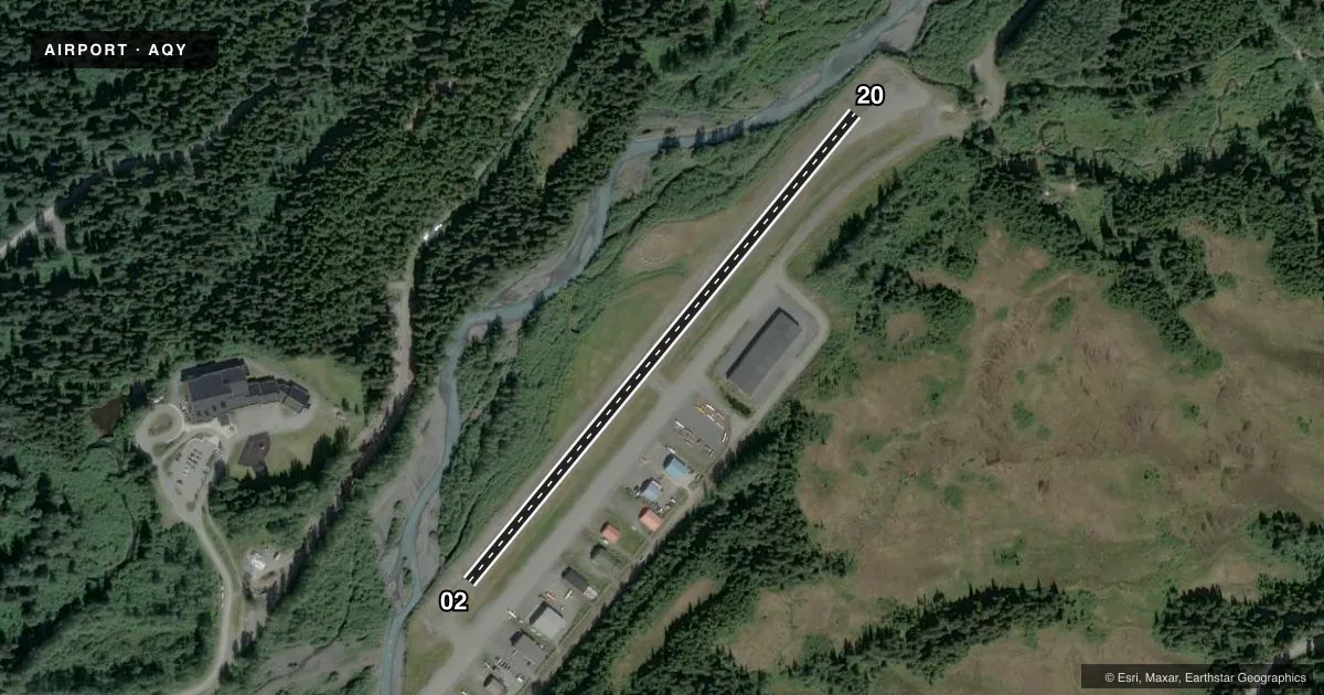
Airport sketch
Runways drawn to scale from FAA survey coordinates, rendered over satellite imagery. Not for navigation.
Approaches & charts
Services on the field
Fuel grades, oxygen, maintenance, ramp storage and lighting — as declared to the FAA by the airport operator.
Fuel & services
- Fuel
- Not available
- Other services
- CARGO,CHTR,PAJA
Ramp & ground
- Transient storage
- Tie-down
- Landing fee
- No fee published
- Customs
- Not available
- Wind indicator
- Yes
- Segmented circle
- Yes
Fuel & FBOs
Cheapest 100LL and Jet A on the field and nearby. Always confirm with the FBO before taxi.
Airport notes
Surface conditions, obstructions, local procedures, lighting outages and other notes published with each FAA cycle.
General notes
- RWY COND UNMNT; RCMD VISUAL INSP BFR LNDG.
- 100 FT CABLE FM HOTEL TO ROUNDHOUSE.
- DALGT HANG GLIDER & PARASAIL ACT 2 NM NE & ON ARPT.
Runway surface & condition
- 02/20200 FT SAFETY AREA BOTH ENDS.
Approach & departure obstructions
- 02THR REFLECTORS; EDGE MKR NA.
- 20THR REFLECTORS; EDGE MKR NA.
Other notes
- OVR GROWN.
VFR map & nearby airports
VFR sectional. Tap any ICAO chip to open that airport.
Key facts · AQY
Answer card- ICAO
- AQY
- Name
- GIRDWOOD
- Location
- GIRDWOOD, ALASKA
- Elevation
- 164 ft MSL
- Traffic pattern altitude
- 1,164 ft MSL (1,000 AGL)
- Control tower
- Non-towered (use CTAF)
- Total runways
- 1
- Longest runway
- 02/20 · 2,095 ft
- Published ILS approaches
- 0
- Published frequencies
- 1
- Magnetic variation
- 25°
- Current flight rules
- VFR
- Current wind
- 360° at 3 kt
- Favored runway now
- RWY 02
Girdwood Airport (AQY) sits in Girdwood, Alaska at 164 ft MSL. It has one runway. Runway 02/20 is 2,095 ft long and gravel. This is a non-towered field, so plan to self-announce on CTAF 122.9. No ILS approaches are published here. The pattern altitude is not published, so use the standard 1,000 ft AGL for light piston operations unless the current Chart Supplement says otherwise.
The runway headings are 40° and 220° magnetic. Published remarks matter here. Runway condition is unmonitored, so a visual inspection before landing is a good idea. Threshold reflectors are published on both ends. Edge markers are not available. The segmented circle markers are overgrown. There is also a 200-foot safety area at both ends of the runway.
No on-field FBOs are listed. Verify services with the airport operator or call the field directly before you go. One more local item to know. Daylight hang glider and parasail activity occurs 2 NM northeast and on the airport. There is also a 100-foot cable from the hotel to the roundhouse, so keep your scan sharp in the area. For any current noise, operating, or surface condition details, check the current FAA Chart Supplement before departure.