METAR & TAF PAWR
PAWR does not publish a METAR.
Showing the nearest reporting station: PAMR (MERRILL FLD) · 41.9 NM away. Conditions at PAWR may differ.
METAR · PAMR
Observed 17:53Z
PAMR 271753Z 20008G15KT 10SM -RA FEW049 OVC070 14/10 A2985 RMK AO2 SLP108 P0000 60001 T01440100 10150 20128 53004
- Wind
- 200° @ 8G15 kt
- Visibility
- 10 SM
- Temp / Dew
- 14°C / 10°C
- Altimeter
- 29.85 inHg
- Clouds
- OVC
- Density alt
- 15 ft
- Ceiling
- 7,000 ft AGL
- Rules
- VFR
Airport info & contacts
Manager on record, flight service, ARTCC, attendance schedule and pattern altitude — published by the FAA and refreshed every 28 days.
Location
- From city
- 1 NM NW
- VFR sectional
- ANCHORAGE
- ARTCC
- ZAN · ANCHORAGE
- NOTAM facility
- ENA (NOTAM-D)
Airport manager
- Name
- PAUL BERTHOLL
- Phone
- 907-783-2232
- Address
- STATE OF AK DOT/PF, GIRDWOOD AK 99587
Flight service · Hours
- FSS ENA
- KENAI907-283-72111-866-864-1737
- Attendance
- Unattended
Frequencies
Tap any row to copy the frequency to your clipboard.
Runways & pattern
Full pagePattern entry · RWY 22
LEFT TRAFFICRunway end performance
| End | TORA | TODA | ASDA | LDA | VGSI | Approach lights | Obstruction |
|---|---|---|---|---|---|---|---|
| 04 | — | — | — | — | — | — | 26', road, 0' from thr, 75' R of cntrln, slope 0 |
| 22 | — | — | — | — | — | — | 3', brush, 0' from thr, 40' R of cntrln, slope 0 |
Declared distances in feet. TORA = takeoff run available, TODA = takeoff distance, ASDA = accelerate-stop, LDA = landing distance.
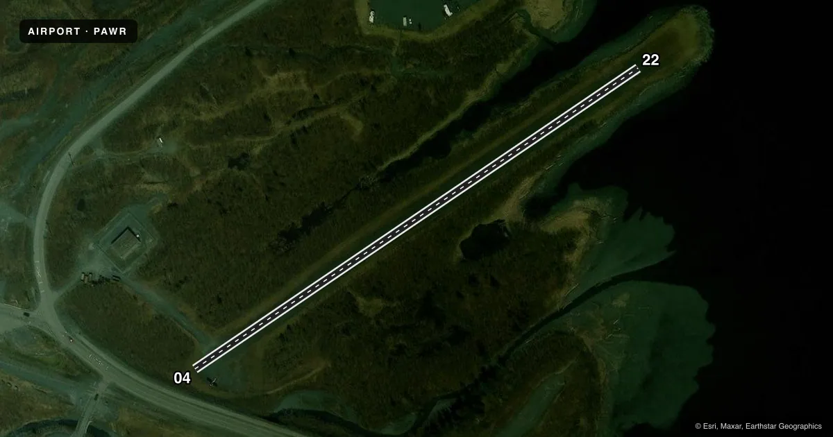
Airport sketch
Runways drawn to scale from FAA survey coordinates, rendered over satellite imagery. Not for navigation.
Approaches & charts
Services on the field
Fuel grades, oxygen, maintenance, ramp storage and lighting — as declared to the FAA by the airport operator.
Fuel & services
- Fuel
- Not available
- Oxygen (bottled)
- Not available
- Oxygen (bulk)
- Not available
- Airframe repair
- Not available
- Power plant repair
- Not available
Ramp & ground
- Transient storage
- Not published
- Landing fee
- No fee published
- Customs
- Not available
- Wind indicator
- Yes
- Segmented circle
- No
Fuel & FBOs
Cheapest 100LL and Jet A on the field and nearby. Always confirm with the FBO before taxi.
Airport notes
Surface conditions, obstructions, local procedures, lighting outages and other notes published with each FAA cycle.
General notes
- APCH TO RY 22 OVER WATER. DISTANCE FROM WATER TO THLD PANELS 205 FT.
- NO SCHEDULED MAINT. NO WINTER MAINT. CLSD FROM FIRST SNOWFALL TIL AFTER BREAKUP.
- WHEN AVAILABLE HOURLY WEATHER REPORTS FROM PORTAGE VISITOR CTR. 135.45. LOCATED WEST SIDE OF PORTAGE PASS.
- RY CONDITION NOT MONITORED. RECOMMEND VISUAL INSPECTION PRIOR TO LDG.
- BIRDS ON AND INVOF ARPT.
- RY 22 SLOPES UP 2% FROM WATER.
- FOR TKOF USE RY 04 ONLY; FIRST 130 FT OF RY 04 UNUSBL. PILE OF LARGE ROCKS LCTD APCH END RY 04. FOR LDGS USE RY 22 ONLY; GO AROUND UNLIKELY.
- WHITTIER AND PORTAGE GLACIER WX CAMERA AVBL ON INTERNET AT HTTPS://WEATHERCAMS.FAA.GOV
- 30 FT TREES, 45 FT EACH SIDE OF RWY CENTERLINE, FULL LENGTH.
Other notes
- WIND INDICATOR MAY BE UNRELIABLE.
VFR map & nearby airports
VFR sectional. Tap any ICAO chip to open that airport.
Key facts · PAWR
Answer card- ICAO
- PAWR
- Name
- WHITTIER
- Location
- WHITTIER, ALASKA
- Elevation
- 39 ft MSL
- Traffic pattern altitude
- 1,039 ft MSL (1,000 AGL)
- Control tower
- Non-towered (use CTAF)
- Total runways
- 1
- Longest runway
- 04/22 · 1,480 ft
- Published ILS approaches
- 0
- Published frequencies
- 1
- Magnetic variation
- 25°
- Current flight rules
- VFR
- Current wind
- 200° at 8 kt
- Favored runway now
- RWY 22
Whittier Airport sits in Whittier, Alaska. Field elevation is 39 ft MSL. The airport has one runway. Runway 04/22 is 1,480 ft long and gravel. There is no control tower. CTAF is 122.9. No ILS approaches are published here. Pattern altitude is not published, so use the standard 1,000 ft AGL for light piston operations unless the current Chart Supplement says otherwise.
This is a short field with some real operational limits. The runway is the only one on site. Runway 22 approaches over water. The threshold is 205 ft from the water. Runway 22 also slopes up 2 percent from the water. For takeoff, use runway 04 only. The first 130 ft of runway 04 is unusable. There is a pile of large rocks at the approach end of runway 04. For landing, use runway 22 only. A go-around is unlikely. Runway condition is not monitored. A visual inspection before landing is a smart move.
There are no on-field FBOs listed. Check with the airport operator or the FBO directly by phone before arrival for current services. Published remarks also note birds in the area, unreliable wind indication and 30 ft trees 45 ft from each side of the centerline for the full length of the runway. The airport has no scheduled maintenance or winter maintenance. It is closed from the first snowfall until after breakup.