METAR & TAF 9Z9
9Z9 does not publish a METAR.
Showing the nearest reporting station: PAWD (SEWARD) · 17.0 NM away. Conditions at 9Z9 may differ.
METAR · PAWD
Observed 20:53Z
PAWD 272053Z AUTO 17007KT 10SM FEW027 SCT039 OVC080 14/12 A2992 RMK AO2 SLP133 T01390117 51011 TSNO $
- Wind
- 170° @ 7 kt
- Visibility
- 10 SM
- Temp / Dew
- 14°C / 12°C
- Altimeter
- 29.92 inHg
- Clouds
- OVC
- Density alt
- 480 ft
- Ceiling
- 8,000 ft AGL
- Rules
- VFR
Airport info & contacts
Manager on record, flight service, ARTCC, attendance schedule and pattern altitude — published by the FAA and refreshed every 28 days.
Location
- From city
- 1 NM N
- VFR sectional
- ANCHORAGE
- ARTCC
- ZAN · ANCHORAGE
- NOTAM facility
- ENA (NOTAM-D)
Airport manager
- Name
- JOSEPH (JD) BOYLE
- Phone
- 907-288-2428
- Address
- 30049 SEWARD HWY MP 23.9, P.O. BOX 1327, SEWARD AK 99664-9516
Flight service · Hours
- FSS ENA
- KENAI907-283-72111-866-864-1737
- Attendance
- Unattended
Frequencies
Tap any row to copy the frequency to your clipboard.
Runways & pattern
Full pagePattern entry · RWY 15
LEFT TRAFFICRunway end performance
| End | TORA | TODA | ASDA | LDA | VGSI | Approach lights | Obstruction |
|---|---|---|---|---|---|---|---|
| 15 | — | — | — | — | — | — | 62', trees, 0' from thr, 120' R of cntrln, slope 0 |
| 33 | — | — | — | — | — | — | 53', tree, 0' from thr, 110' R of cntrln, slope 0 |
Declared distances in feet. TORA = takeoff run available, TODA = takeoff distance, ASDA = accelerate-stop, LDA = landing distance.
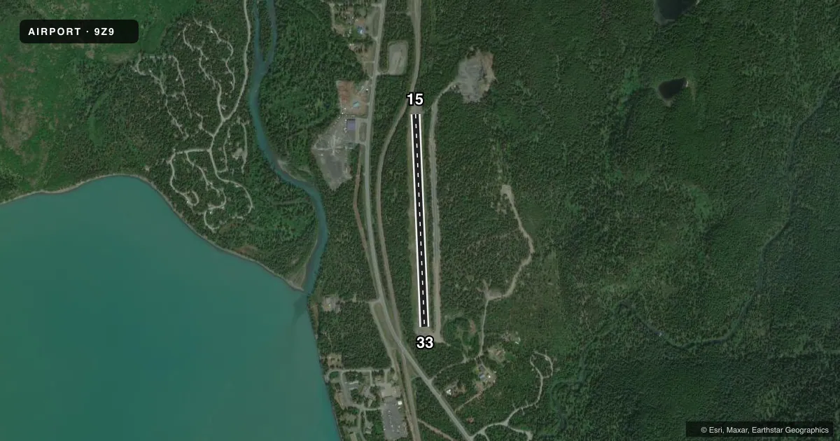
Airport sketch
Runways drawn to scale from FAA survey coordinates, rendered over satellite imagery. Not for navigation.
Approaches & charts
Services on the field
Fuel grades, oxygen, maintenance, ramp storage and lighting — as declared to the FAA by the airport operator.
Fuel & services
- Fuel
- Not available
Ramp & ground
- Transient storage
- Not published
- Landing fee
- No fee published
- Customs
- Not available
- Wind indicator
- Yes
- Segmented circle
- No
Fuel & FBOs
Cheapest 100LL and Jet A on the field and nearby. Always confirm with the FBO before taxi.
Airport notes
Surface conditions, obstructions, local procedures, lighting outages and other notes published with each FAA cycle.
General notes
- MAINT IREG.
- RWY COND UNMNT; RCMND VISUAL INSP BFR USE.
- OVRN DOWNSLOPE 5%.
- VEHICLES ON RWY.
- WX CAMERA AVBL ON INTERNET AT HTTPS://WEATHERCAMS.FAA.GOV
Runway surface & condition
- 15/33THR PANELS DMGD. UNDULATES; SOFT DURG SPRING; RUTS E SIDE.
Approach & departure obstructions
- 15APCH SLOPE 0:1.
- 33APCH SLOPE 0:1.
- 15EDGE NOT MKD.
- 33EDGE NOT MKD.
Other notes
- WINDSOCK BLW TREELINE; MAY BE UNRELIABLE.
- MANAGER907-262-1187.
VFR map & nearby airports
VFR sectional. Tap any ICAO chip to open that airport.
Key facts · 9Z9
Answer card- ICAO
- 9Z9
- Name
- LAWING
- Location
- LAWING, ALASKA
- Elevation
- 484 ft MSL
- Traffic pattern altitude
- 1,484 ft MSL (1,000 AGL)
- Control tower
- Non-towered (use CTAF)
- Total runways
- 1
- Longest runway
- 15/33 · 2,355 ft
- Published ILS approaches
- 0
- Published frequencies
- 1
- Magnetic variation
- 25°
- Current flight rules
- VFR
- Current wind
- 170° at 7 kt
- Favored runway now
- RWY 15
LAWING sits in Alaska at 484 ft MSL. It has one runway, 15/33, which is 2,355 ft long and gravel. There is no control tower. CTAF is 122.9. No ILS approaches are published here.
Pattern altitude is not published. Use 1,000 ft AGL as the standard reference for light piston traffic unless the current Chart Supplement says otherwise. The field is in a remote setting, so expect to work from the published data and your own preflight judgment. The windsock is below the treeline and may be unreliable. Runway condition is unmonitored, so a visual inspection before use is recommended.
The published remarks also matter. The threshold panels on 15/33 are damaged and undulate. The surface can be soft in spring with ruts on the east side. The runway edges are not marked. Vehicles are on the runway. The overrun drops away at about 5 percent. The approach slope for both runway 15 and runway 33 is zero to one. There is no on-field FBO listed. Check with the airport manager at 907-262-1187 for current field status before you go.