METAR & TAF PFCB
Current METAR
Observed 09:10Z
PFCB 270910Z AUTO 00000KT 10SM OVC025 13/13 A2989 RMK AO2 T01320130
- Wind
- 000° @ 0 kt
- Visibility
- 10 SM
- Temp / Dew
- 13°C / 13°C
- Altimeter
- 29.89 inHg
- Clouds
- OVC
- Density alt
- -117 ft
- Ceiling
- 2,500 ft AGL
- Rules
- MVFR
Airport info & contacts
Manager on record, flight service, ARTCC, attendance schedule and pattern altitude — published by the FAA and refreshed every 28 days.
Location
- From city
- 1 NM NE
- VFR sectional
- SEWARD
- ARTCC
- ZAN · ANCHORAGE
- NOTAM facility
- JNU (NOTAM-D)
Airport manager
- Name
- ROB SMITH
- Phone
- 907-262-1187
- Address
- P. O. BOX 1327, SOLDOTNA AK 99669
Flight service · Hours
- FSS JNU
- JUNEAU907-586-73801-866-297-2236
- Attendance
- Unattended
Frequencies
Tap any row to copy the frequency to your clipboard.
Runways & pattern
Full pagePattern entry · RWY 16
LEFT TRAFFICRunway end performance
| End | TORA | TODA | ASDA | LDA | VGSI | Approach lights | Obstruction |
|---|---|---|---|---|---|---|---|
| 16 | — | — | — | — | — | — | 10', brush, 0' from thr, 102' R of cntrln, slope 0 |
| 34 | — | — | — | — | — | — | 14', brush, 0' from thr, 110' R of cntrln, slope 0 |
Declared distances in feet. TORA = takeoff run available, TODA = takeoff distance, ASDA = accelerate-stop, LDA = landing distance.
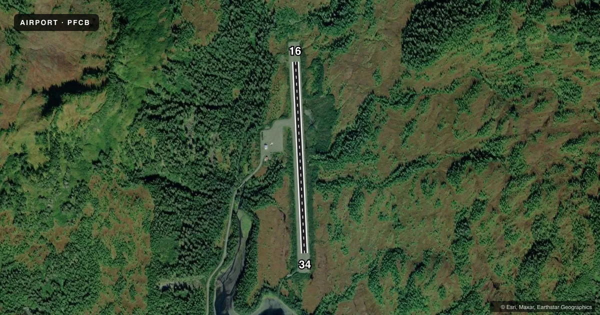
Airport sketch
Runways drawn to scale from FAA survey coordinates, rendered over satellite imagery. Not for navigation.
Approaches & charts
Services on the field
Fuel grades, oxygen, maintenance, ramp storage and lighting — as declared to the FAA by the airport operator.
Fuel & services
- Fuel
- Not available
Ramp & ground
- Transient storage
- Not published
- Lighting schedule
- SEE RMK
- Beacon schedule
- SEE RMK
- Beacon
- White / Green (civil land)(WG)
- Wind indicator
- Lighted
- Segmented circle
- Yes
Fuel & FBOs
Cheapest 100LL and Jet A on the field and nearby. Always confirm with the FBO before taxi.
Airport notes
Surface conditions, obstructions, local procedures, lighting outages and other notes published with each FAA cycle.
General notes
- RAPIDLY RISING TRRN N, E & W QUAD.
Lighting notes
- RDO CTL.
- ACTIVATE MIRL RWY 16/34 - CTAF.
Approach & departure obstructions
- 16REFLECTIVE CONES & LGTS.
- 34REFLECTIVE CONES & LGTS.
Other notes
- 16/34SHOULDERS & SAFETY AREAS SOFT WHEN WET; WATER PONDS IN SAFETY AREAS BOTH ENDS.
VFR map & nearby airports
VFR sectional. Tap any ICAO chip to open that airport.
Key facts · PFCB
Answer card- ICAO
- PFCB
- Name
- CHENEGA BAY
- Location
- CHENEGA, ALASKA
- Elevation
- 68.9 ft MSL
- Traffic pattern altitude
- 1,068.9 ft MSL (1,000 AGL)
- Control tower
- Non-towered (use CTAF)
- Total runways
- 1
- Longest runway
- 16/34 · 3,000 ft
- Published ILS approaches
- 0
- Published frequencies
- 1
- Magnetic variation
- 19°
- Current flight rules
- MVFR
- Current wind
- 000° at 0 kt
- Favored runway now
- –
Chenega Bay Airport (PFCB) sits at Chenega, Alaska. Field elevation is 68.9 ft MSL. The airport has one runway. Runway 16/34 is 3,000 ft long and gravel. There is no control tower. CTAF is 122.9.
No ILS approaches are published here. Pattern altitude is not published in the facts, so use the current FAA Chart Supplement before you go. The published remarks matter at this field. The shoulders and safety areas can be soft when wet. Water ponds in the safety areas at both ends. Runway 16 and runway 34 both have reflective cones and lights at the ends. Medium intensity runway lights on 16/34 are activated by radio on the CTAF. A radio control beacon is also listed.
There are no on-field FBOs listed. Contact the airport operator directly or call the field on CTAF for current local services before arrival. Terrain is a real factor here. Rapidly rising terrain is located in the north, east and west quadrants. That makes arrival and departure planning important, especially in marginal weather or with a heavy load. The runway heading is magnetic. Runway 16 and 34 are aligned to the published magnetic directions.