METAR & TAF PAWD
Current METAR
Observed 21:53Z
PAWD 272153Z AUTO 16010KT 10SM OVC035 14/11 A2993 RMK AO2 SLP134 T01390111 TSNO $
- Wind
- 160° @ 10 kt
- Visibility
- 10 SM
- Temp / Dew
- 14°C / 11°C
- Altimeter
- 29.93 inHg
- Clouds
- OVC
- Density alt
- -98 ft
- Ceiling
- 3,500 ft AGL
- Rules
- VFR
Airport info & contacts
Manager on record, flight service, ARTCC, attendance schedule and pattern altitude — published by the FAA and refreshed every 28 days.
Location
- From city
- 2 NM NE
- VFR sectional
- SEWARD
- ARTCC
- ZAN · ANCHORAGE
- NOTAM facility
- SWD (NOTAM-D)
Airport manager
- Name
- JOSEPH (JD) BOYLE
- Phone
- 907-262-1187
- Address
- 30049 SEWARD HWY MP 23.9, P.O. BOX 1327, SEWARD AK 99664
Flight service · Hours
- FSS ENA
- KENAI907-283-72111-866-864-1737
- Attendance
- Unattended
Frequencies
Tap any row to copy the frequency to your clipboard.
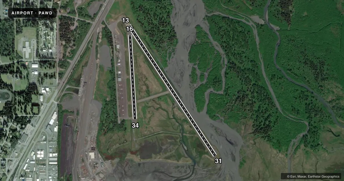
Runways & pattern
Full pagePattern entry · RWY 13
LEFT TRAFFIC| Runway | Heading (°M) | Length | Surface | Traffic |
|---|---|---|---|---|
| 13/31Favored | 127° / 307° | 4,249 ft | ASPH | Standard L |
| 16/34 | 158° / 338° | 2,289 ft | ASPH | Standard L |
Runway end performance
| End | TORA | TODA | ASDA | LDA | VGSI | Approach lights | Obstruction |
|---|---|---|---|---|---|---|---|
| 13 | — | — | — | — | — | — | 6', brdg, 200' from thr, 90' R of cntrln, slope 0 |
| 31 | — | — | — | — | VASI 4-box left(3°) | — | 5', brush, 202' from thr, 35' R of cntrln, slope 0 |
| 16 | — | — | — | — | — | — | 68', trees, 885' from thr, 220' R of cntrln, slope 10 |
Declared distances in feet. TORA = takeoff run available, TODA = takeoff distance, ASDA = accelerate-stop, LDA = landing distance.
Airport sketch
Runways drawn to scale from FAA survey coordinates, rendered over satellite imagery. Not for navigation.
Approaches & charts
Services on the field
Fuel grades, oxygen, maintenance, ramp storage and lighting — as declared to the FAA by the airport operator.
Fuel & services
- Fuel
- 100LLA
- Other services
- CHTR
Ramp & ground
- Transient storage
- Tie-down
- Hangar
- Landing fee
- No fee published
- Customs
- Not available
- Lighting schedule
- SEE RMK
- Beacon schedule
- SS-SR
- Beacon
- White / Green (civil land)(WG)
- Wind indicator
- Yes
- Segmented circle
- Yes
Fuel & FBOs
Cheapest 100LL and Jet A on the field and nearby. Always confirm with the FBO before taxi.
Airport notes
Surface conditions, obstructions, local procedures, lighting outages and other notes published with each FAA cycle.
General notes
- HVY ACFT RSTRD TO N TWY & N 400 FT OF APRON.
- RCMDD PROC IN EFCT 1 MAY-15 SEP TO AVOID SEASONAL USE HELI 1 NM SSW.
- WX CAMERA AVBL ON INTERNET AT HTTPS://WEATHERCAMS.FAA.GOV
- BIRDS WI 10 NM SPRING-FALL.
- FIXED WING OPS OVR 12500 LB NA.
- COLD TEMPERATURE AIRPORT. ALTITUDE CORRECTION REQUIRED AT OR BELOW -3C.
- RCMD VISUAL INSP PRIOR TO TKOFF OR LNDG; MNTND ON IREG BASIS.
Lighting notes
- ACTVT VASI RWY 31; MIRL RWY 13/31 - CTAF.
Runway surface & condition
- 16/34DURG WINTER 4 IN DIP 15 IN WIDE FM NORTH THR.
Approach & departure obstructions
- 31TREES & SHRUBS 100 FT FM RWY END BOTH SIDES.
- 34TREES & SHRUBS 0-200 FT FM THR BOTH SIDES.
- 31APCH SLOPE 0:1.
- 31RWY 31 VASI UNUSBL BYD 5 DEG RIGHT OF CNTRLN; OFFSET 5 DEG CLKWS FM CNTRLN. RWY 31 VASI UNUSBL BYD 3 NM; OBSTN CLNC BYD 3 NM NA.
- 13CTLG OBSTN EXCEEDS 45 DEG SLOPE.
Other notes
- TPA FIXED WING 1000 FT AGL. RWYS 31 & 34 ARRIVALS MAINTAIN AT LEAST 800 FT AGL UNTIL TURNING FINAL. RWYS 13 & 16 DEPARTURES CLIMB STRAIGHT AHEAD TO AT LEAST 800 FT AGL BEFORE TURNING WESTBOUND.
VFR map & nearby airports
VFR sectional. Tap any ICAO chip to open that airport.
Key facts · PAWD
Answer card- ICAO
- PAWD
- Name
- SEWARD
- Location
- SEWARD, ALASKA
- Elevation
- 27.7 ft MSL
- Traffic pattern altitude
- 1,027.7 ft MSL (1,000 AGL)
- Control tower
- Non-towered (use CTAF)
- Total runways
- 2
- Longest runway
- 13/31 · 4,249 ft
- Published ILS approaches
- 0
- Published frequencies
- 1
- Magnetic variation
- 19°
- Current flight rules
- VFR
- Current wind
- 160° at 10 kt
- Favored runway now
- RWY 13
PAWD is in Seward, Alaska. Field elevation is 27.7 ft MSL. The airport has two asphalt runways. The longest is runway 13/31 at 4,249 ft. There is no control tower. CTAF is 122.9.
No ILS approaches are published here. Pattern altitude for fixed wing is 1,000 ft AGL. That puts the normal pattern at 1,027.7 ft MSL. Seward Air is on the field. It carries 100LL and Jet A. Call (907) 491-1357 for current service details.
A few published remarks matter for a first-time arrival. Runway 31 lights are CTAF controlled. The VASI for runway 31 is usable only within 5 degrees right of centerline. It is also unusable beyond 3 NM. Trees and shrubs sit 100 ft from the runway end on both sides of runway 31. Runway 13 has a cataloged obstruction that exceeds a 45 degree slope. Heavy aircraft are restricted to the north taxiway and the north 400 ft of the apron. Seasonal helicopter activity is a factor from May 1 to September 15. Birds are present within 10 NM during spring through fall. Check the current FAA Chart Supplement and the airport operator for any current operating notes before you go.