METAR & TAF JLA
JLA does not publish a METAR.
Showing the nearest reporting station: PAWD (SEWARD) · 23.1 NM away. Conditions at JLA may differ.
METAR · PAWD
Observed 21:53Z
PAWD 272153Z AUTO 16010KT 10SM OVC035 14/11 A2993 RMK AO2 SLP134 T01390111 TSNO $
- Wind
- 160° @ 10 kt
- Visibility
- 10 SM
- Temp / Dew
- 14°C / 11°C
- Altimeter
- 29.93 inHg
- Clouds
- OVC
- Density alt
- 445 ft
- Ceiling
- 3,500 ft AGL
- Rules
- VFR
Airport info & contacts
Manager on record, flight service, ARTCC, attendance schedule and pattern altitude — published by the FAA and refreshed every 28 days.
Location
- From city
- 3 NM E
- VFR sectional
- ANCHORAGE
- ARTCC
- ZAN · ANCHORAGE
- NOTAM facility
- ENA (NOTAM-D)
Airport manager
- Name
- ADAM SULLIVAN/ROB SMITH
- Phone
- 907-262-1187
- Address
- STATE OF ALASKA - DOTPF, P.O. BOX 1327, SOLDOTNA AK 99669
Flight service · Hours
- FSS ENA
- KENAI907-283-72111-866-864-1737
- Attendance
- Unattended
Frequencies
Tap any row to copy the frequency to your clipboard.
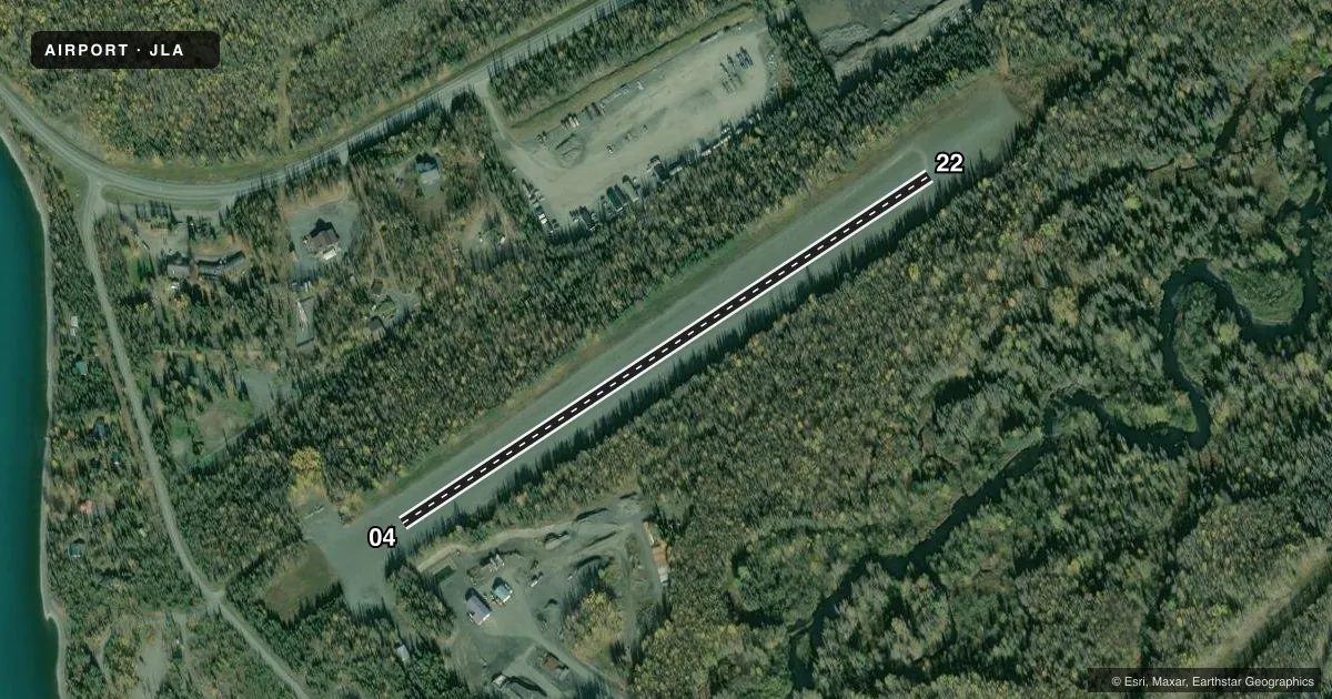
Runways & pattern
Full pagePattern entry · RWY 22
LEFT TRAFFICRunway end performance
| End | TORA | TODA | ASDA | LDA | VGSI | Approach lights | Obstruction |
|---|---|---|---|---|---|---|---|
| 04 | — | — | — | — | — | — | 40', trees, 0' from thr, 120' R of cntrln, slope 0 |
| 22 | — | — | — | — | — | — | 4', brush, 0' from thr, 117' R of cntrln, slope 0 |
Declared distances in feet. TORA = takeoff run available, TODA = takeoff distance, ASDA = accelerate-stop, LDA = landing distance.
Airport sketch
Runways drawn to scale from FAA survey coordinates, rendered over satellite imagery. Not for navigation.
Approaches & charts
Services on the field
Fuel grades, oxygen, maintenance, ramp storage and lighting — as declared to the FAA by the airport operator.
Fuel & services
- Fuel
- Not available
Ramp & ground
- Transient storage
- Tie-down
- Landing fee
- No fee published
- Customs
- Not available
- Wind indicator
- Yes
- Segmented circle
- No
Fuel & FBOs
Cheapest 100LL and Jet A on the field and nearby. Always confirm with the FBO before taxi.
Airport notes
Surface conditions, obstructions, local procedures, lighting outages and other notes published with each FAA cycle.
General notes
- IREG STATE MAINT; RCMD VISUAL INSP BFR LNDG.
- WX CAMERA AVBL ON INTERNET AT HTTPS://WEATHERCAMS.FAA.GOV
Runway surface & condition
- 04/22EDGES NOT MKD.
Approach & departure obstructions
- 04MTN 2 SM FM APCH END.
Other notes
- WINDSOCK BLW TREELINE; MAY BE UNRELIABLE.
VFR map & nearby airports
VFR sectional. Tap any ICAO chip to open that airport.
Key facts · JLA
Answer card- ICAO
- JLA
- Name
- QUARTZ CREEK
- Location
- COOPER LANDING, ALASKA
- Elevation
- 466 ft MSL
- Traffic pattern altitude
- 1,466 ft MSL (1,000 AGL)
- Control tower
- Non-towered (use CTAF)
- Total runways
- 1
- Longest runway
- 04/22 · 2,200 ft
- Published ILS approaches
- 0
- Published frequencies
- 1
- Magnetic variation
- 25°
- Current flight rules
- VFR
- Current wind
- 160° at 10 kt
- Favored runway now
- RWY 22
Quartz Creek Airport sits in Cooper Landing, Alaska. The field elevation is 466 ft MSL. It has one runway, 04/22, which is 2,200 ft long and surfaced gravel-dirt. The airport is non-towered. CTAF is 122.9. No ILS approaches are published here.
For pattern work, the published pattern altitude is not listed. Use standard 1,000 ft AGL for light piston aircraft unless the current Chart Supplement or local procedure says otherwise. Runway 04 has a mountain about 2 statute miles from the approach end. Runway edges are not marked. The windsock is below the treeline, so it may not give a clean read. A visual inspection before landing is recommended because state maintenance can be irregular.
There are no on-field FBOs listed in the facts. Plan on self-briefing the field and checking current conditions before you go. The weather camera is available online through FAA weather cams. This is a good airport to treat as a short, rough-field stop with terrain in the picture. Keep the mountain near the 04 end in mind. Verify current runway condition, wind and any local notes with the airport operator or the current FAA Chart Supplement before arrival.