METAR & TAF PALH
Current METAR
Observed 21:53Z
PALH 272153Z AUTO 17006KT 10SM -RA OVC085 14/11 A2989 RMK AO2 RAB07E16B48 SLP123 P0000 T01440106 TSNO
- Wind
- 170° @ 6 kt
- Visibility
- 10 SM
- Temp / Dew
- 14°C / 11°C
- Altimeter
- 29.89 inHg
- Clouds
- OVC
- Density alt
- 16 ft
- Ceiling
- 8,500 ft AGL
- Rules
- VFR
Airport info & contacts
Manager on record, flight service, ARTCC, attendance schedule and pattern altitude — published by the FAA and refreshed every 28 days.
Location
- From city
- 3 NM SW
- VFR sectional
- ANCHORAGE
- Pattern altitude
- 600 ft AGL · 679 ft MSL
- ARTCC
- ZAN · ANCHORAGE
- NOTAM facility
- LHD (NOTAM-D)
Airport manager
- Name
- TIM COONS
- Phone
- 907-266-2741
- Address
- STATE OF AK - DOT & PF, PO BOX 196960, ANCHORAGE AK 99519-6960
Flight service · Hours
- FSS ENA
- KENAI907-283-72111-866-864-1737
- Attendance
- ALL
Frequencies
Tap any row to copy the frequency to your clipboard.
Runways & pattern
Full pagePattern entry · RWY 14
LEFT TRAFFICRunway end performance
| End | TORA | TODA | ASDA | LDA | VGSI | Approach lights | Obstruction |
|---|---|---|---|---|---|---|---|
| 14 | — | — | — | — | — | — | 68', tree, 936' from thr, 285' R of cntrln, slope 13 |
| 32 | — | — | — | — | — | — | 78', tree, 1117' from thr, 350' R of cntrln, slope 14 |
Declared distances in feet. TORA = takeoff run available, TODA = takeoff distance, ASDA = accelerate-stop, LDA = landing distance.
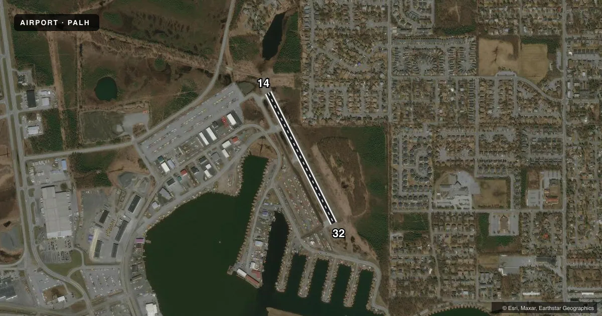
Airport sketch
Runways drawn to scale from FAA survey coordinates, rendered over satellite imagery. Not for navigation.
Approaches & charts
Services on the field
Fuel grades, oxygen, maintenance, ramp storage and lighting — as declared to the FAA by the airport operator.
Fuel & services
- Fuel
- 100100LLA
- Airframe repair
- Major
- Power plant repair
- Major
- Other services
- AFRT,AVNCS,BCHGR,CARGO,CHTR,INSTR
Ramp & ground
- Transient storage
- Tie-down
- Hangar
- Landing fee
- No fee published
- Customs
- Not available
- Lighting schedule
- SS-SR
- Wind indicator
- Yes
- Segmented circle
- No
Fuel & FBOs
Cheapest 100LL and Jet A on the field and nearby. Always confirm with the FBO before taxi.
Airport notes
Surface conditions, obstructions, local procedures, lighting outages and other notes published with each FAA cycle.
General notes
- FLOATING DEBRIS ON LAKE.
- AREA NW & SW OF LAKE SPENARD FM CANAL EASTWARD 1500 FT NOT VSBL FM ATCT.
- WATERFOWL, NESTING AREAS & LRG FLOCKS OF BIRDS SPRING-FALL INVOF ARPT.
- PUB RAMPS ON N & W SHORE OF LAKE HOOD.
- ANCHORAGE WX CAMERA AVBL ON INTERNET AT HTTPS://WEATHERCAMS.FAA.GOV
- NOISE SENSITIVE AREA IN EFCT - AMGR FOR INFO.
- TWY V PCL SECURITY GATE E OF TWY E; KEY 121.75 3 TIMES.
- SEE NOTICE IN SECTION C FOR ARPT LAYOUT GRAPHIC.
- CTN: PAEW; TWY/ROAD AROUND LAKE HOOD MULTI USE; RCMD LNDG LGT DURG TAX.
- TWY H-2/LAKESHORE TWY GATES PCL; KEY 121.75 3 TIMES.
- NON-RDO OPS PPR - 907-271-5936; REQ TSFR TO ATCT; RMN WI 15 MIN OF ETA. NGT NON-RDO OPS NA.
- LAKE CLSD TO ACFT OVR 12500 LB FREEZUP-DEC 31; OVERFLOWS INTO ICE MAY OCR DURG WINTER.
- FOR PRIOR WINTER SKI OPS AVBLTY - LCL NOTAMS & ATCT.
- N POTHOLE DSGND NO WAKE AREA.
- WATERLANES TO LAKE HOOD SEAPLANE BASE ELEV 76 FT.
- ARR & DEP ROUTES; SEE AREA NOTICES.
- BFR LV SLIPS ADJ TO N/S WATER LANE ALG SHORELINE CTC ATCT - 126.8 OR 907-271-6549.
Fuel notes
- 100LLLCTD RWY 14/32 TSNT PRKG & FBO.
Runway surface & condition
- 14/32LTD TO 9000 LB OR LESS.
- 14/32TFC PAT OVERLAPS SEADROME PAT.
VFR map & nearby airports
VFR sectional. Tap any ICAO chip to open that airport.
Key facts · PALH
Answer card- ICAO
- PALH
- Name
- LAKE HOOD
- Location
- ANCHORAGE, ALASKA
- Elevation
- 79.3 ft MSL
- Traffic pattern altitude
- 679.3 ft MSL (600 AGL)
- Control tower
- Towered · 24
- Total runways
- 1
- Longest runway
- 14/32 · 2,200 ft
- Published ILS approaches
- 0
- Published frequencies
- 8
- Magnetic variation
- 25°
- Current flight rules
- VFR
- Current wind
- 170° at 6 kt
- Favored runway now
- RWY 14
Lake Hood is in Anchorage, Alaska. Field elevation is 79.3 ft MSL. The airport has one runway, 14/32, which is 2,200 ft long and surfaced gravel-dirt. The tower is open 24 hours. No ILS approaches are published here.
Pattern altitude is 600 ft AGL. That is 679.3 ft MSL. Runway 14/32 is limited to aircraft with a gross weight of 9,000 lb or less. The traffic pattern on 14/32 overlaps the seadrome pattern, so spacing matters. The field sits in the Anchorage Class C environment. Check current procedures before arrival if you are not already familiar with the local flow.
Crowley Aviation Fuels is on the field. It carries 100LL. Fuel is also located at runway 14/32 transient parking and at the FBO. Published remarks also note floating debris on the lake. Non-radio operations need prior permission. Night non-radio operations are not authorized. Taxiway gates on H-2, Lakeshore and Taxiway V are prior permission required. A noise sensitive area is in effect. If you are new to Lake Hood, plan for close traffic. Expect mixed seaplane and landplane operations. Use careful coordination with the tower.