METAR & TAF AN0
AN0 does not publish a METAR.
Showing the nearest reporting station: PASX (SOLDOTNA) · 6.8 NM away. Conditions at AN0 may differ.
METAR · PASX
Observed 19:56Z
PASX 271956Z AUTO 19010G15KT 150V220 10SM SCT042 18/07 A2987 RMK AO2 SLP119 T01830072 TSNO
- Wind
- 190° @ 10G15 kt
- Visibility
- 10 SM
- Temp / Dew
- 18°C / 7°C
- Altimeter
- 29.87 inHg
- Clouds
- SCT
- Density alt
- 717 ft
- Ceiling
- Unlimited
- Rules
- VFR
Airport info & contacts
Manager on record, flight service, ARTCC, attendance schedule and pattern altitude — published by the FAA and refreshed every 28 days.
Location
- From city
- 1 NM W
- VFR sectional
- ANCHORAGE
- ARTCC
- ZAN · ANCHORAGE
Airport manager
- Name
- TAMMY FARRELL
- Phone
- 907-394-4675
- Address
- 36928 RODELEE LANE, STERLING AK 99672
Flight service · Hours
- FSS ENA
- KENAI907-283-72111-866-864-1737
Frequencies
Tap any row to copy the frequency to your clipboard.
Runways & pattern
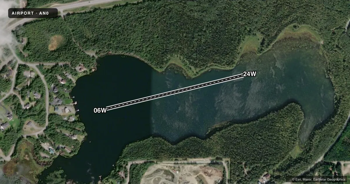
Full pagePattern entry · RWY 24W
LEFT TRAFFICAirport sketch
Runways drawn to scale from FAA survey coordinates, rendered over satellite imagery. Not for navigation.
Approaches & charts
Services on the field
Fuel grades, oxygen, maintenance, ramp storage and lighting — as declared to the FAA by the airport operator.
Fuel & services
- Fuel
- Not available
Ramp & ground
- Transient storage
- Not published
Fuel & FBOs
Cheapest 100LL and Jet A on the field and nearby. Always confirm with the FBO before taxi.
Airport notes
Surface conditions, obstructions, local procedures, lighting outages and other notes published with each FAA cycle.
General notes
- OWNER DESIRES SPB BE CHARTED.
Other notes
- PER ASN # 2022-WSA-89-LAP TO DECONFLICT LOCAL TRAFFIC PATTERN AIRSPACE, FAA RECOMMENDS LOA ESTABLISHED WITH SURROUNDING ARPTS & ALL SURROUNDING AIRPORTS USE AK84 CTAF 122.5.
VFR map & nearby airports
VFR sectional. Tap any ICAO chip to open that airport.
Key facts · AN0
Answer card- ICAO
- AN0
- Name
- SCOUT LAKE - MUSKRAT COVE
- Location
- STERLING, ALASKA
- Elevation
- 238 ft MSL
- Traffic pattern altitude
- 1,238 ft MSL (1,000 AGL)
- Control tower
- Non-towered (use CTAF)
- Total runways
- 1
- Longest runway
- 06W/24W · 1,869 ft
- Published ILS approaches
- 0
- Published frequencies
- 1
- Magnetic variation
- –
- Current flight rules
- VFR
- Current wind
- 190° at 10 kt
- Favored runway now
- RWY 24W
Scout Lake - Muskrat Cove (AN0) sits near Sterling, Alaska. Field elevation is 238 ft MSL. This is a non-towered seaplane base with one runway. The longest runway is 06W/24W at 1,869 ft on water. Runway headings are published as magnetic 76.3008809529873 degrees and 256.300880952987 degrees.
No ILS approaches are published here. CTAF is 122.5. Pattern altitude is not published in the facts. Use the current FAA Chart Supplement before you go. The published remarks also say the FAA has recommended a letter of agreement with surrounding airports to help deconflict local traffic pattern airspace. The owner also wants the special purpose airspace charted.
There are no on-field FBOs listed. Plan on verifying services with the airport operator or the field by phone before arrival. For a first-time pilot, the main things to sort out are water operations, local traffic flow and nearby airport coordination. This is not a place to guess at pattern work or airspace details. Check the current Chart Supplement for the latest published guidance before flying in.