METAR & TAF PASX
Current METAR
Observed 15:56Z
PASX 271556Z AUTO VRB03KT 10SM -RA OVC100 13/09 A2985 RMK AO2 SLP114 P0001 T01280094 TSNO
- Wind
- VAR @ 3 kt
- Visibility
- 10 SM
- Temp / Dew
- 13°C / 9°C
- Altimeter
- 29.85 inHg
- Clouds
- OVC
- Density alt
- -13 ft
- Ceiling
- 10,000 ft AGL
- Rules
- VFR
Airport info & contacts
Manager on record, flight service, ARTCC, attendance schedule and pattern altitude — published by the FAA and refreshed every 28 days.
Location
- From city
- 1 NM SE
- VFR sectional
- ANCHORAGE
- Pattern altitude
- 793 ft AGL · 906 ft MSL
- ARTCC
- ZAN · ANCHORAGE
- NOTAM facility
- SXQ (NOTAM-D)
Airport manager
- Name
- KYLE KORNELIS
- Phone
- 907-398-1440
- Address
- 177 NORTH BIRCH ST, SOLDOTNA AK 99669
Flight service · Hours
- FSS ENA
- KENAI907-283-72111-866-864-1737
- Attendance
- 0700-1600
Frequencies
Tap any row to copy the frequency to your clipboard.
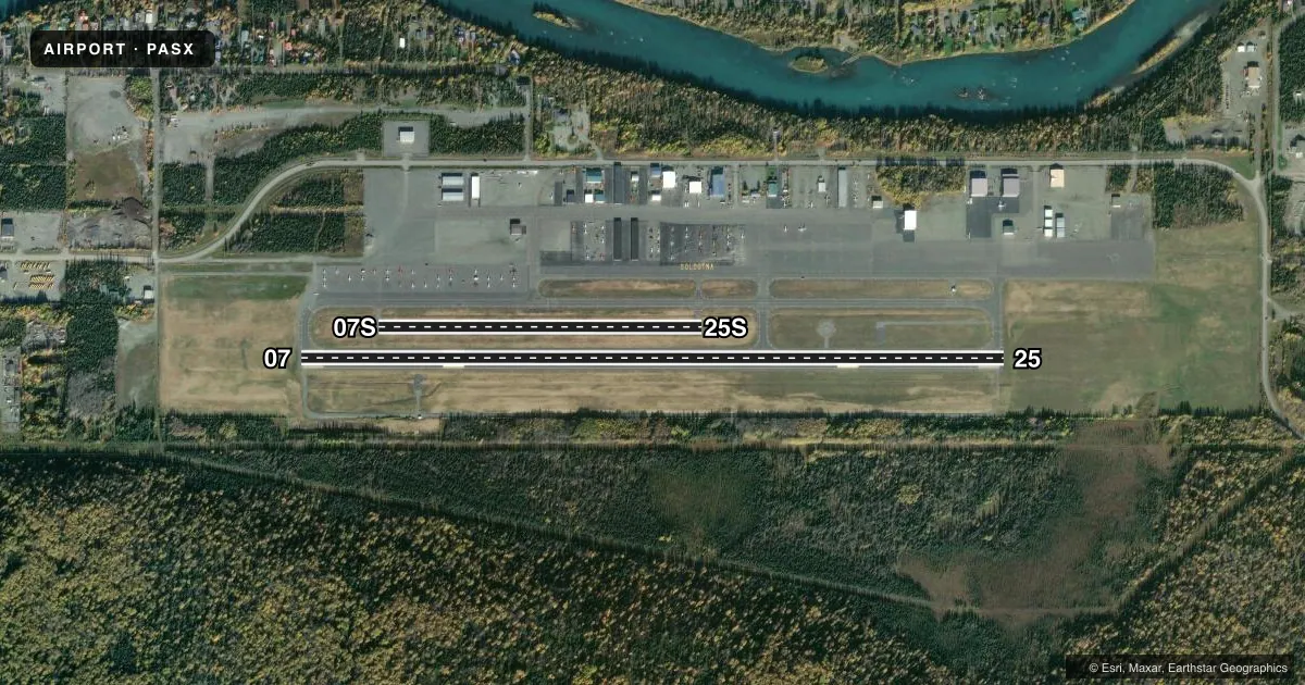
Runways & pattern
Full pagePattern entry · RWY 07
RIGHT TRAFFIC| Runway | Heading (°M) | Length | Surface | Traffic |
|---|---|---|---|---|
| 07/25Favored | 75° / 255° | 5,001 ft | ASPH | 07 R |
| 07S/25S | 75° / 255° | 2,300 ft | GRVL-DIRT | Standard L |
Runway end performance
| End | TORA | TODA | ASDA | LDA | VGSI | Approach lights | Obstruction |
|---|---|---|---|---|---|---|---|
| 07 | — | — | — | — | PAPI 4-box right(3°) | — | 45', trees, 1470' from thr, 390' R of cntrln, slope 28 |
| 25 | — | — | — | — | PAPI 4-box right(3°) | — | 50', trees, 2265' from thr, 118' R of cntrln, slope 41 |
Declared distances in feet. TORA = takeoff run available, TODA = takeoff distance, ASDA = accelerate-stop, LDA = landing distance.
Airport sketch
Runways drawn to scale from FAA survey coordinates, rendered over satellite imagery. Not for navigation.
Approaches & charts
Services on the field
Fuel grades, oxygen, maintenance, ramp storage and lighting — as declared to the FAA by the airport operator.
Fuel & services
- Fuel
- 100LLA
- Airframe repair
- Major
- Power plant repair
- Major
- Other services
- AVNCS,CHTR,RNTL
Ramp & ground
- Transient storage
- Tie-down
- Landing fee
- Yes
- Customs
- Not available
- Lighting schedule
- SEE RMK
- Beacon schedule
- SS-SR
- Beacon
- White / Green (civil land)(WG)
- Wind indicator
- Lighted
- Segmented circle
- Yes
Fuel & FBOs
Cheapest 100LL and Jet A on the field and nearby. Always confirm with the FBO before taxi.
Airport notes
Surface conditions, obstructions, local procedures, lighting outages and other notes published with each FAA cycle.
General notes
- LRG CARGO ACFT USE E RAMP FOR PRKG/UNLOADING.
- TSNT PRKG S OF TRML BLDG; ROWS 26-28 & 40-44.
- W APRON NOT MNTND.
- RWY COND UNMNT; RCMD VISUAL INSP BFR LNDG.
- ULTRALIGHT ACFT INVOF ARPT, NO ULTRALIGHT STRIP.
- WX CAMERA AVBL ON INTERNET AT HTTPS://WEATHERCAMS.FAA.GOV
- SIMUL/PARL OPS NA; SEQ - CTAF.
- GRVL LNDG AREA N SIDE & PARL TO RWY 07/25; MRKD BY CONES; NOT MNTND IN WINTER.
Lighting notes
- ACTVT PAPI RWY 07 & 25; MIRL RWY 07/25; WINDSOCKS - CTAF.
Fuel notes
- 100LLAVBL 24 HR WITH CREDIT CARD.
- A0700-1600 - 907-262-5388; CALL OUT FEE AFT HR - 907-420-7153.
Other notes
- 12500 LBS & OVR.
- MANAGER907-262-4672.
VFR map & nearby airports
VFR sectional. Tap any ICAO chip to open that airport.
Key facts · PASX
Answer card- ICAO
- PASX
- Name
- SOLDOTNA
- Location
- SOLDOTNA, ALASKA
- Elevation
- 113.4 ft MSL
- Traffic pattern altitude
- 906.4 ft MSL (793 AGL)
- Control tower
- Non-towered (use CTAF)
- Total runways
- 2
- Longest runway
- 07/25 · 5,001 ft
- Published ILS approaches
- 0
- Published frequencies
- 1
- Magnetic variation
- 15°
- Current flight rules
- VFR
- Current wind
- 000° at 3 kt
- Favored runway now
- RWY 07
Soldotna Airport is in Soldotna, Alaska. The field elevation is 113.4 ft MSL. It has two runways. The longest is runway 07/25 at 5,001 ft. Runway 07S/25S is 2,300 ft and gravel-dirt. There is no control tower. CTAF is 122.5. Pattern altitude is 793 ft AGL, which is 906.4 ft MSL.
No ILS approaches are published here. Runway 07 and 25 have PAPI and medium intensity runway lights. Windsocks are on the CTAF frequency. The published remarks say runway condition is unmonitored, so a visual check before landing is smart. The gravel landing area is on the north side and runs parallel to 07/25. It is marked by cones. It is not maintained in winter. Simultaneous and parallel operations are not authorized. Sequencing is by CTAF.
There are no on-field FBOs listed. Fuel service is available from 0700 to 1600. Call ahead for after-hours service if needed. Large cargo aircraft use the east ramp. Transient parking is south of the terminal building in rows 26-28 and 40-44. Ultralight aircraft operate in the vicinity. There is no ultralight strip. For current field conditions, check the FAA Chart Supplement or call the airport manager before you go.