METAR & TAF PAKA
PAKA does not publish a METAR.
Showing the nearest reporting station: PAVD (VALDEZ PIONEER FLD) · 20.4 NM away. Conditions at PAKA may differ.
METAR · PAVD
Observed 19:56Z
PAVD 271956Z 10003KT 10SM SCT025 BKN030 BKN040 14/11 A3000
- Wind
- 100° @ 3 kt
- Visibility
- 10 SM
- Temp / Dew
- 14°C / 11°C
- Altimeter
- 30.00 inHg
- Clouds
- BKN
- Density alt
- -142 ft
- Ceiling
- 3,000 ft AGL
- Rules
- MVFR
Airport info & contacts
Manager on record, flight service, ARTCC, attendance schedule and pattern altitude — published by the FAA and refreshed every 28 days.
Location
- From city
- 0 NM NW
- VFR sectional
- ANCHORAGE
- ARTCC
- ZAN · ANCHORAGE
- NOTAM facility
- JNU (NOTAM-D)
Airport manager
- Name
- TODD BISCHOFF.DIMOND
- Phone
- 907-835-5658
- Address
- PO BOX 507, VALDEZ AK 99686
Flight service · Hours
- FSS JNU
- JUNEAU907-586-73801-866-297-2236
- Attendance
- Unattended
Frequencies
Tap any row to copy the frequency to your clipboard.
Runways & pattern
Full pagePattern entry · RWY 13
LEFT TRAFFICRunway end performance
| End | TORA | TODA | ASDA | LDA | VGSI | Approach lights | Obstruction |
|---|---|---|---|---|---|---|---|
| 13 | — | — | — | — | — | — | 12', brush, 0' from thr, 120' R of cntrln, slope 0 |
| 31 | — | — | — | — | — | — | 20', brush, 0' from thr, 115' R of cntrln, slope 0 |
Declared distances in feet. TORA = takeoff run available, TODA = takeoff distance, ASDA = accelerate-stop, LDA = landing distance.
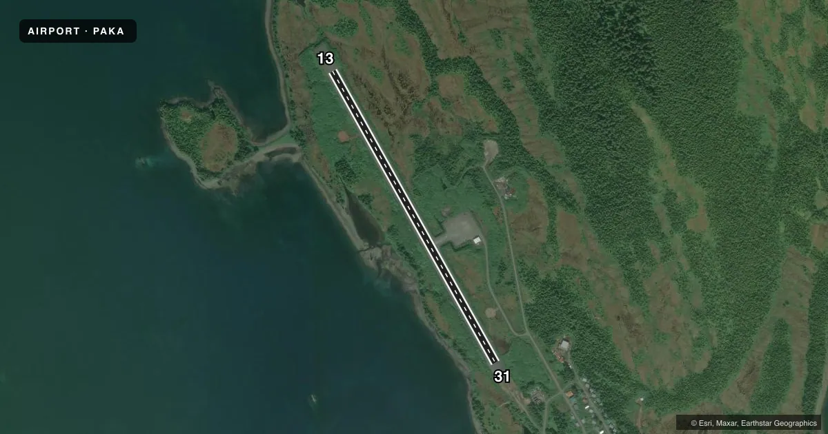
Airport sketch
Runways drawn to scale from FAA survey coordinates, rendered over satellite imagery. Not for navigation.
Approaches & charts
Services on the field
Fuel grades, oxygen, maintenance, ramp storage and lighting — as declared to the FAA by the airport operator.
Fuel & services
- Fuel
- Not available
Ramp & ground
- Transient storage
- Not published
- Landing fee
- No fee published
- Customs
- Not available
- Lighting schedule
- SEE RMK
- Beacon schedule
- SS-SR
- Beacon
- White / Green (civil land)(WG)
- Wind indicator
- Yes
- Segmented circle
- Yes
Fuel & FBOs
Cheapest 100LL and Jet A on the field and nearby. Always confirm with the FBO before taxi.
Airport notes
Surface conditions, obstructions, local procedures, lighting outages and other notes published with each FAA cycle.
General notes
- BE ALERT: ROCKS IN WATER AREA LOW TIDE.
- HIGH TRRN NW-SE.
- RWY COND NOT MNTD; RCMD VISUAL INSP PRIOR TO LNDG.
Lighting notes
- ACTVT MIRL RWY 13/31 - CTAF.
Runway surface & condition
- 13/31SAFTEY AREA 150 BY 4300 FT; ALL SIDES ROUGH WITH POT HOLES & LRG ROCKS.
Approach & departure obstructions
- 31RWY 13 THR 45 FT HYR.
- 31SFC SLOPES UP.
Other notes
- THIS AIRPORT HAS BEEN SURVEYED BY THE NATIONAL GEODETIC SURVEY.
- SEGMENTED CIRCLES OVERGROWN.
VFR map & nearby airports
VFR sectional. Tap any ICAO chip to open that airport.
Key facts · PAKA
Answer card- ICAO
- PAKA
- Name
- TATITLEK
- Location
- TATITLEK, ALASKA
- Elevation
- 61.9 ft MSL
- Traffic pattern altitude
- 1,061.9 ft MSL (1,000 AGL)
- Control tower
- Non-towered (use CTAF)
- Total runways
- 1
- Longest runway
- 13/31 · 3,701 ft
- Published ILS approaches
- 0
- Published frequencies
- 1
- Magnetic variation
- 20°
- Current flight rules
- MVFR
- Current wind
- 100° at 3 kt
- Favored runway now
- RWY 13
PAKA is the airport serving Tatitlek, Alaska. It sits at 61.9 ft MSL. The field has one runway, 13/31, which is 3,701 ft of gravel. There is no control tower. CTAF is 122.7. No ILS approaches are published here.
The published pattern altitude is not listed, so use the standard 1,000 ft AGL unless local procedures or the current Chart Supplement say otherwise. The runway lighting on 13/31 is medium intensity and is activated by CTAF. That matters after dark or in lower visibility. The published remarks also call out high terrain northwest to southeast. Runway 13 threshold is 45 ft higher than the opposite end. Runway 31 slopes up. The runway surface is not maintained, so a visual inspection before landing is a good idea. The safety area has rough sides with potholes and large rocks. There are also rocks in the water area at low tide. Segmented circles are overgrown. No on-field FBOs are listed, so verify services with the airport operator or the FBO directly by phone before you go.