METAR & TAF CKU
CKU does not publish a METAR.
Showing the nearest reporting station: PACV (MERLE K (MUDHOLE) SMITH) · 8.0 NM away. Conditions at CKU may differ.
METAR · PACV
Observed 19:53Z
PACV 271953Z 00000KT 5SM RA BR OVC006 12/11 A2994 RMK AO2 RAE06B25 SLP139 P0004 T01220111
- Wind
- 000° @ 0 kt
- Visibility
- 5 SM
- Temp / Dew
- 12°C / 11°C
- Altimeter
- 29.94 inHg
- Clouds
- OVC
- Density alt
- -312 ft
- Ceiling
- 600 ft AGL
- Rules
- IFR
Airport info & contacts
Manager on record, flight service, ARTCC, attendance schedule and pattern altitude — published by the FAA and refreshed every 28 days.
Location
- From city
- 1 NM E
- VFR sectional
- ANCHORAGE
- ARTCC
- ZAN · ANCHORAGE
- NOTAM facility
- JNU (NOTAM-D)
Airport manager
- Name
- ROBERT MATTSON
- Phone
- 907-424-3202
- Address
- BOX 598, CORDOVA AK 99574
Flight service · Hours
- FSS JNU
- JUNEAU907-586-73801-866-297-2236
- Attendance
- Unattended
Frequencies
Tap any row to copy the frequency to your clipboard.
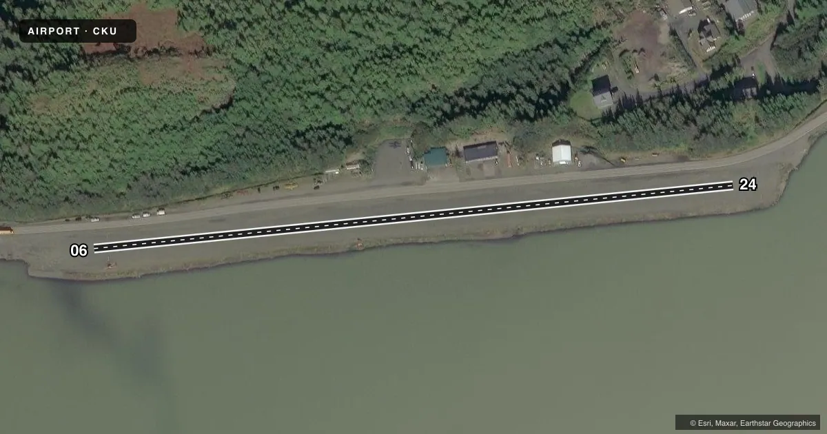
Runways & pattern
Full pagePattern entry · RWY 06
RIGHT TRAFFICRunway end performance
| End | TORA | TODA | ASDA | LDA | VGSI | Approach lights | Obstruction |
|---|---|---|---|---|---|---|---|
| 06 | — | — | — | — | — | — | 115', trees, 0' from thr, 124' R of cntrln, slope 0 |
| 24 | — | — | — | — | — | — | 15', road, 0' from thr, 78' R of cntrln, slope 0 |
Declared distances in feet. TORA = takeoff run available, TODA = takeoff distance, ASDA = accelerate-stop, LDA = landing distance.
Airport sketch
Runways drawn to scale from FAA survey coordinates, rendered over satellite imagery. Not for navigation.
Approaches & charts
Services on the field
Fuel grades, oxygen, maintenance, ramp storage and lighting — as declared to the FAA by the airport operator.
Fuel & services
- Fuel
- Not available
- Oxygen (bottled)
- Not available
- Oxygen (bulk)
- Not available
- Airframe repair
- Major
- Power plant repair
- Major
- Other services
- CARGO
Ramp & ground
- Transient storage
- Tie-down
- Landing fee
- No fee published
- Customs
- Not available
- Wind indicator
- Yes
- Segmented circle
- No
Fuel & FBOs
Cheapest 100LL and Jet A on the field and nearby. Always confirm with the FBO before taxi.
Airport notes
Surface conditions, obstructions, local procedures, lighting outages and other notes published with each FAA cycle.
General notes
- STEEP RIDGE & HILL ALONG N EDGE; STRONG E WINDS; RWY SUBJ TO STRONG DOWNDRAFTS; BIRDS ROOST ON S SIDE; MOUNTAINS 3 MI FM AER RWY 24.
- SEAPLANE OPERS IN APCH TO RY 24.
- SPB OPERS IN EYAK LAKE; EYAK LAKE FREEZES IN WINTER-TIDEWATER REMAINS OPEN.
- RY COND NOT MONITORED; RECOMMEND VISUAL INSPECTION PRIOR TO LANDING.
- SNOW REMOVAL ON IRREGULAR BASIS.
- BUSY RESIDENTIAL ROAD BORDERS NORTHSIDE & PARALLELS RY.
- RY EDGE CONES REMOVED FOR WINTER 15 OCT THRU 1 MAY.
- NO PUBL SEAPLANE DOCK; . PUB SEAPLANE FACILITIES AT SMALL BOAT HARBOR.
- BIRDS INVOF ARPT DURING SUMMER MONTHS.
- WX CAMERA AVBL ON INTERNET AT HTTPS://WEATHERCAMS.FAA.GOV
Approach & departure obstructions
- 06RY 06/24 MARKED WITH REFLECTIVE CONES.
Other notes
- ESTABD PRIOR TO 1959.
- TIE DOWNS ACROSS BUSY ROAD THAT PARRALLELS AIRSTRIP ON NORTH; BE ALERT TAXIING ACROSS ROAD.
- 06/24LARGER GRAVEL AT APPROACH END OF RUNWAY 24.
VFR map & nearby airports
VFR sectional. Tap any ICAO chip to open that airport.
Key facts · CKU
Answer card- ICAO
- CKU
- Name
- CORDOVA MUNI
- Location
- CORDOVA, ALASKA
- Elevation
- 59 ft MSL
- Traffic pattern altitude
- 1,059 ft MSL (1,000 AGL)
- Control tower
- Non-towered (use CTAF)
- Total runways
- 1
- Longest runway
- 06/24 · 1,800 ft
- Published ILS approaches
- 0
- Published frequencies
- 1
- Magnetic variation
- 26°
- Current flight rules
- IFR
- Current wind
- 000° at 0 kt
- Favored runway now
- –
Cordova Muni sits in Cordova, Alaska at 59 ft MSL. It has one runway. Runway 06/24 is 1,800 ft long and gravel. There is no control tower. CTAF is 122.5. No ILS approaches are published here.
Pattern altitude is not published. Use 1,000 ft AGL as the standard light piston pattern unless the current Chart Supplement says otherwise. The field has a steep ridge and hill along the north edge. Strong east winds can create downdrafts. Mountains sit about 3 miles from the approach end of runway 24. Birds are a factor in summer. Runway condition is not monitored, so a visual check before landing makes sense. Runway 06/24 is marked with reflective cones. The cones are removed for winter from 15 October through 1 May.
Seaplane traffic is part of the picture here. Seaplane operations occur on the approach to runway 24. Eyak Lake is used for seaplane activity. It freezes in winter, while tidewater remains open. There is no public seaplane dock. Public seaplane facilities are at Small Boat Harbor. Tie downs are across a busy road that parallels the north side of the strip, so taxiing across that road deserves extra attention.