METAR & TAF PAMD
Current METAR
Observed 20:56Z
PAMD 272056Z AUTO VRB03KT 10SM OVC009 12/10 A2997 RMK AO2 SLP149 T01170100 53015 $
- Wind
- VAR @ 3 kt
- Visibility
- 10 SM
- Temp / Dew
- 12°C / 10°C
- Altimeter
- 29.97 inHg
- Clouds
- OVC
- Density alt
- -298 ft
- Ceiling
- 900 ft AGL
- Rules
- IFR
Airport info & contacts
Manager on record, flight service, ARTCC, attendance schedule and pattern altitude — published by the FAA and refreshed every 28 days.
Location
- From city
- 1 NM S
- VFR sectional
- SEWARD
- ARTCC
- ZAN · ANCHORAGE
- NOTAM facility
- MDO (NOTAM-D)
Airport manager
- Name
- US GOV, FAA KENAI SSC
- Phone
- 907-283-4526
- Address
- 427 N. WILLOW ST., KENAI AK 99611
Flight service · Hours
- FSS JNU
- JUNEAU907-586-73801-866-297-2236
- Attendance
- Unattended
Frequencies
Tap any row to copy the frequency to your clipboard.
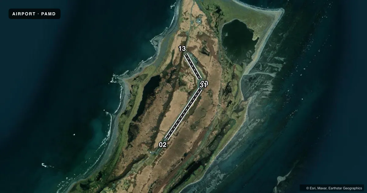
Runways & pattern
Full pagePattern entry · RWY 31
LEFT TRAFFIC| Runway | Heading (°M) | Length | Surface | Traffic |
|---|---|---|---|---|
| 02/20 | 16° / 196° | 3,158 ft | GRVL | Standard L |
| 13/31Favored | 131° / 311° | 1,500 ft | TURF-DIRT | Standard L |
Runway end performance
| End | TORA | TODA | ASDA | LDA | VGSI | Approach lights | Obstruction |
|---|---|---|---|---|---|---|---|
| 02 | — | — | — | — | — | — | 15', road, 0' from thr, 94' R of cntrln, slope 0 |
| 20 | — | — | — | — | — | — | 15', road, 0' from thr, 84' R of cntrln, slope 0 |
| 13 | — | — | — | — | — | — | 15', road, 0' from thr, 74' R of cntrln, slope 0 |
| 31 | — | — | — | — | — | — | 15', road, 0' from thr, 90' R of cntrln, slope 0 |
Declared distances in feet. TORA = takeoff run available, TODA = takeoff distance, ASDA = accelerate-stop, LDA = landing distance.
Airport sketch
Runways drawn to scale from FAA survey coordinates, rendered over satellite imagery. Not for navigation.
Approaches & charts
Services on the field
Fuel grades, oxygen, maintenance, ramp storage and lighting — as declared to the FAA by the airport operator.
Fuel & services
- Fuel
- Not available
Ramp & ground
- Transient storage
- Not published
- Landing fee
- No fee published
- Customs
- Not available
- Wind indicator
- Yes
- Segmented circle
- No
Fuel & FBOs
Cheapest 100LL and Jet A on the field and nearby. Always confirm with the FBO before taxi.
Airport notes
Surface conditions, obstructions, local procedures, lighting outages and other notes published with each FAA cycle.
General notes
- WX CAMERA ON RWY EDGE. WX CAMERA AVBL ON INTERNET AT HTTPS://WEATHERCAMS.FAA.GOV
- WATERFOWL & WILDLIFE INVOF OF RWYS.
Runway surface & condition
- 02/20DOWN SLOPE TO S. SAFETY AREAS SOFT.
- 13/31CLSD INDEFLY. MAINT NA. GRASS & ROCKS ON RWY.
Approach & departure obstructions
- 02CTN: EAGLE NEST ON APCH. ELEC TRANSFORMER WI SAFETY AREA APCH END.
- 312 FT BRUSH APCH END.
- 02CONES.
- 13CONES.
- 20CONES.
- 31CONES.
VFR map & nearby airports
VFR sectional. Tap any ICAO chip to open that airport.
Key facts · PAMD
Answer card- ICAO
- PAMD
- Name
- MIDDLETON ISLAND
- Location
- MIDDLETON ISLAND, ALASKA
- Elevation
- 100.4 ft MSL
- Traffic pattern altitude
- 1,100.4 ft MSL (1,000 AGL)
- Control tower
- Non-towered (use CTAF)
- Total runways
- 2
- Longest runway
- 02/20 · 3,158 ft
- Published ILS approaches
- 0
- Published frequencies
- 1
- Magnetic variation
- 18°
- Current flight rules
- IFR
- Current wind
- 000° at 3 kt
- Favored runway now
- RWY 31
Middleton Island Airport sits on Middleton Island in Alaska. Field elevation is 100.4 ft MSL. The airport has 2 runways. The longest is Runway 02/20 at 3,158 ft. There is no control tower. CTAF is 122.9.
No ILS approaches are published here. Pattern altitude is not published, so use standard 1,000 ft AGL for light piston operations unless the current FAA Chart Supplement says otherwise. Runway 13/31 is listed at 1,500 ft, but it is closed indefinitely. The published remarks also call out cones on the runways, soft safety areas on 02/20 and wildlife in the area. Runway 02 has an eagle nest on approach plus an electrical transformer within the safety area at the approach end. Runway 31 has a two foot brush at the approach end.
There are no on-field FBOs listed. Plan fuel and service stops accordingly. The field is remote and weather can change fast on the coast, so check the current FAA Chart Supplement and the airport operator before you go. The published weather camera on the runway edge may help with a quick look at conditions. It does not replace a proper preflight brief. Expect a simple, no-tower environment with limited runway options and a few surface and wildlife hazards that matter on arrival.