METAR & TAF PADQ
Current METAR
Observed 05:53Z
PADQ 280553Z 09003KT 10SM CLR 13/07 A3006
- Wind
- 090° @ 3 kt
- Visibility
- 10 SM
- Temp / Dew
- 13°C / 7°C
- Altimeter
- 30.06 inHg
- Clouds
- CLR
- Density alt
- -316 ft
- Ceiling
- Unlimited
- Rules
- VFR
Airport info & contacts
Manager on record, flight service, ARTCC, attendance schedule and pattern altitude — published by the FAA and refreshed every 28 days.
Location
- From city
- 4 NM SW
- VFR sectional
- KODIAK
- ARTCC
- ZAN · ANCHORAGE
- NOTAM facility
- ADQ (NOTAM-D)
Airport manager
- Name
- CLARK YATSIK
- Phone
- 907-487-4952
- Address
- 1500 ANTON LARSON RD, KODIAK AK 99615
Flight service · Hours
- FSS ENA
- KENAI907-283-72111-866-864-1737
- Attendance
- SAME AS ARPT MAINT HRS
Frequencies
Tap any row to copy the frequency to your clipboard.
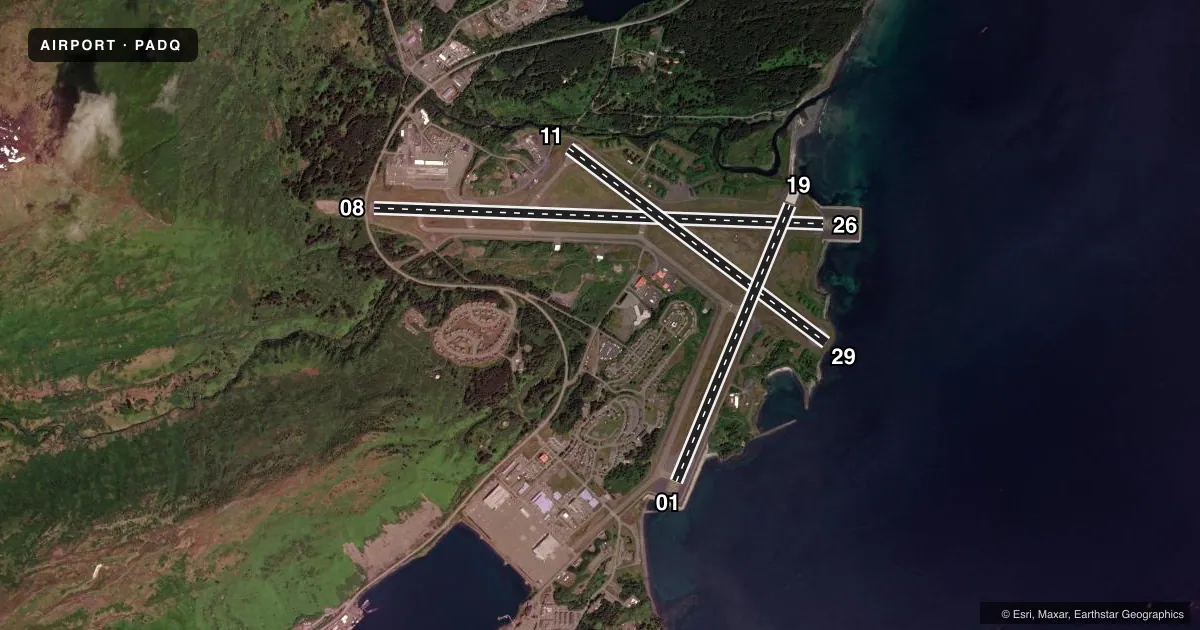
Runways & pattern
Full pagePattern entry · RWY 08
LEFT TRAFFIC| Runway | Heading (°M) | Length | Surface | Traffic |
|---|---|---|---|---|
| 08/26Favored | 78° / 258° | 7,534 ft | ASPH | 26 R |
| 11/29 | 113° / 293° | 5,400 ft | ASPH | 29 R |
| 01/19 | 8° / 188° | 5,010 ft | ASPH | 01 R |
Runway end performance
| End | TORA | TODA | ASDA | LDA | VGSI | Approach lights | Obstruction |
|---|---|---|---|---|---|---|---|
| 08 | 7,534' | 7,534' | 7,534' | 6,396' | — | — | 2427', hill, 5686' from thr, 0' R of cntrln, slope 2 |
| 26 | 7,534' | 7,534' | 7,534' | 7,534' | VASI 2-box left(2.05°) | — | — |
| 11 | 4,960' | 4,960' | 4,960' | 4,402' | — | — | 60', trees, 560' from thr, 0' R of cntrln, slope 6 |
| 29 | 4,844' | 4,844' | 4,844' | 4,402' | VASI 2-box left | — | — |
| 01 | — | — | — | — | VASI 2-box left(3.75°) | — | 130', trees, 3000' from thr, 0' R of cntrln, slope 21 |
Declared distances in feet. TORA = takeoff run available, TODA = takeoff distance, ASDA = accelerate-stop, LDA = landing distance.
Airport sketch
Runways drawn to scale from FAA survey coordinates, rendered over satellite imagery. Not for navigation.
Approaches & charts
ILS · 1
Services on the field
Fuel grades, oxygen, maintenance, ramp storage and lighting — as declared to the FAA by the airport operator.
Fuel & services
- Fuel
- 100LLA1
- Airframe repair
- Minor
- Power plant repair
- Minor
- Other services
- AFRT,CARGO,CHTR
Ramp & ground
- Transient storage
- Not published
- Landing fee
- No fee published
- Customs
- Not available
- Lighting schedule
- SEE RMK
- Beacon schedule
- SS-SR
- Beacon
- White / Green (civil land)(WG)
- Wind indicator
- Lighted
- Segmented circle
- Yes
Fuel & FBOs
Cheapest 100LL and Jet A on the field and nearby. Always confirm with the FBO before taxi.
Airport notes
Surface conditions, obstructions, local procedures, lighting outages and other notes published with each FAA cycle.
General notes
- JASU-5(A/M32A-86); 1(MA-1A). AVBL USCG ONLY.
- FIRST 3000 FT RWY 08, FIRST 2000 FT RWY 01 & PTNS OF ALL TXYS NOT VIS FM ATCT.
- UNLGT HIGH TRRN ALL QUADS. BIRDS, WATERFOWL & WILDLIFE ON & INVOF OF ARPT.
- SNOW REMOVAL & DEICING NA 1830-0500.
- ROAD WI 50 FT OF THR ALL RWYS.
- LNDG RWY 08 & 11; TKOF RWY 26 & 29 NOT RCMDD DURG DARKNESS OR WHEN MT PEAKS OBSCD.
- TSNT MIL CTC MAINT - 164.550 OR KODIAK AIR 345.0 FOR MARSHALLER.
- PAEW ON & INVOF RWY.
- 72 HR PPR FOR ACES TO CG RAMP. TSNT MUST PRVD OWN SVC & MAINT CREW. EXP DLA OTR TIME EXC SAR & MEDEVAC - V487-5889/C907-487-5889.
- ARR CTC KODIAK AIR 345.0 OR 164.55 FOR CLRNC ON CG RAMP, MARSHALLER & PRKG SVC. TXY TO CG RAMP XS TWO ROADS; ACTVT CROSSING LIGHTS 122.8; ON 5 CLICKS; OFF 7 CLICKS. NONSTD TAX LINE OBS CLNC ON CG RAMP.
- CG RAMP CLSD TO WINGSPAN GTR THAN 132.5 FT.
- WX CAMERA AVBL ON INTERNET AT HTTPS://WEATHERCAMS.FAA.GOV.
- ARPT SAND LRG GRAD THAN FAA RCMDD/SEE AC150/5200-30.
- WX BLN LAUNCH FAC ON ARPT; SEE INSIDE BACK CVR FOR OPS DTLS.
- LIFEFLIGHT/MEDEVAC USE RAMP AREA IN OR ADJ TO TSNT PRKG E SIDE OF COML RAMP; OUTSIDE OF SIDA MARKINGS.
- LOCKED WHEEL TURNS NA ALL SFCS.
- PPR ALL OPS GTR THAN 200000 LB GROSS TKOF & LNDG WT.
- TSA REGULATED ARPT. SEE 49 CFR 1542. ALL GATES & DOORS MUST BE SECURED AT ALL TIMES. TSNT OR UNFAMILIAR PILOTS - AMGR WITH QUESTIONS.
Lighting notes
- ACTVT REIL RWY 01 & 26; VASI RWY 01, 26, 29; HIRL RWY 01/19, 08/26, 11/29; TWY LGTS - CTAF.
Runway surface & condition
- 01/19PCR VALUE: 480/F/C/X/T
- 08/26PCR VALUE: 480/F/C/X/T
- 11/29PCR VALUE: 480/F/C/X/T
- 08/26WHEN ATCT CLSD; LNDG RWY 26 OR DEP RWY 08 PSBL TALL VESSELS XNG RWY 26 APCH 3200-5000 FT FM APCH END. 120 FT SHIPS X CHNL BTN PUFFIN ISLAND/ADQ; ALL HR.
Approach & departure obstructions
- 087 FT BLAST BARRIER 40 FT FM THR; HWY 60 FT FM THR.
- 08MTUS TRRN ON APCH; RCMD USE ONLY BY PILOTS FAMILIAR. HEAVY LIFT CARGO RSTRD FM FULL PWR TKOFF WO PPR - AMGR.
- 01OMNI DRCTNL.
- 01RWY 01 VASI DOES NOT PRVD OBS CLNC BYD 2.0 NM FM THR; UNUSBL BYD 2.0 NM.
- 08APCH RATIO 2:1 TO DTHR.
Other notes
- CLSD TO ACR OPS GTR THAN 30 PAX SEATS EXC PPR IN WRITING - AMGR P.O. BOX 1500 ANTON LARSON ROAD KODIAK AK 99615.
- 1ARPT INFO - 907-487-4952 MON-FRI 0700-1630.
- AFRTSUMMER MAINT APR 1 - OCT 13 DAILY 0600-1830. WINTER MAINT OCT 14 - MAR 31 DAILY 0500-1830.
VFR map & nearby airports
VFR sectional. Tap any ICAO chip to open that airport.
Key facts · PADQ
Answer card- ICAO
- PADQ
- Name
- KODIAK
- Location
- KODIAK, ALASKA
- Elevation
- 78.7 ft MSL
- Traffic pattern altitude
- 1,078.7 ft MSL (1,000 AGL)
- Control tower
- Towered · 0630-2000 1 OCT-31 MAR, 0700-2200 1 APR-30 SEP.
- Total runways
- 3
- Longest runway
- 08/26 · 7,534 ft
- Published ILS approaches
- 1
- Published frequencies
- 8
- Magnetic variation
- 14°
- Current flight rules
- VFR
- Current wind
- 090° at 3 kt
- Favored runway now
- RWY 08
Kodiak Airport sits in Kodiak, Alaska. Field elevation is 78.7 ft MSL. The airport has 3 asphalt runways. The longest is runway 08/26 at 7,534 ft. The tower is open 0630-2000 from 1 Oct to 31 Mar. It is open 0700-2200 from 1 Apr to 30 Sep. Pattern altitude is not published. Use 1,000 ft AGL for light piston operations unless local guidance says otherwise.
Runway 26 has the field’s ILS. Runway 01, 26 and 29 have VASI. High intensity lighting is on runways 01/19, 08/26 and 11/29. Taxiway lights are controlled by CTAF. Island Air Service is on the field. It carries AVGAS 100LL, Jet A and Jet A Prist. Call (907) 487-4596 before arrival if you need current ramp or fuel details.
This is a mountain airport. The published remarks call for caution on runway 08 because of mountainous terrain on approach. Runway 08 and 11 are the preferred landing runways. Runway 26 and 29 are not recommended for takeoff in darkness or when the mountain peaks are obscured. The first 3000 ft of runway 08, the first 2000 ft of runway 01 and parts of the taxiways are not visible from the tower. Kodiak is a TSA-regulated airport. Transient pilots should expect security controls. Contact the airport manager with questions before arrival.