METAR & TAF PORI
PORI does not publish a METAR.
Showing the nearest reporting station: PADQ (KODIAK) · 13.9 NM away. Conditions at PORI may differ.
METAR · PADQ
Observed 04:53Z
PADQ 280453Z 08003KT 10SM CLR 13/07 A3006
- Wind
- 080° @ 3 kt
- Visibility
- 10 SM
- Temp / Dew
- 13°C / 7°C
- Altimeter
- 30.06 inHg
- Clouds
- CLR
- Density alt
- -362 ft
- Ceiling
- Unlimited
- Rules
- VFR
Airport info & contacts
Manager on record, flight service, ARTCC, attendance schedule and pattern altitude — published by the FAA and refreshed every 28 days.
Location
- From city
- 2 NM NNE
- VFR sectional
- KODIAK
- ARTCC
- ZAN · ANCHORAGE
- NOTAM facility
- ENA (NOTAM-D)
Airport manager
- Name
- CLARK YATSIK
- Phone
- 907-487-4952
- Address
- 1500 ANTON LARSON RD, KODIAK AK 99615
Flight service · Hours
- FSS ENA
- KENAI907-283-72111-866-864-1737
- Attendance
- Unattended
Frequencies
Tap any row to copy the frequency to your clipboard.
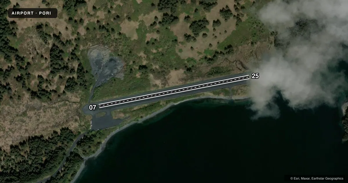
Runways & pattern
Full pagePattern entry · RWY 07
RIGHT TRAFFICRunway end performance
| End | TORA | TODA | ASDA | LDA | VGSI | Approach lights | Obstruction |
|---|---|---|---|---|---|---|---|
| 07 | — | — | — | — | — | — | 28', tree, 21' from thr, 96' R of cntrln, slope 0 |
| 25 | — | — | — | — | — | — | 12', brush, 0' from thr, 87' R of cntrln, slope 0 |
Declared distances in feet. TORA = takeoff run available, TODA = takeoff distance, ASDA = accelerate-stop, LDA = landing distance.
Airport sketch
Runways drawn to scale from FAA survey coordinates, rendered over satellite imagery. Not for navigation.
Approaches & charts
Services on the field
Fuel grades, oxygen, maintenance, ramp storage and lighting — as declared to the FAA by the airport operator.
Fuel & services
- Fuel
- Not available
Ramp & ground
- Transient storage
- Not published
- Landing fee
- No fee published
- Customs
- Not available
- Lighting schedule
- SEE RMK
- Beacon schedule
- SS-SR
- Beacon
- White / Green (civil land)(WG)
- Wind indicator
- Yes
- Segmented circle
- No
Fuel & FBOs
Cheapest 100LL and Jet A on the field and nearby. Always confirm with the FBO before taxi.
Airport notes
Surface conditions, obstructions, local procedures, lighting outages and other notes published with each FAA cycle.
General notes
- EXP DOWNDRAFTS DURG NE WIND.
- RWY COND UNMNT; RCMD VISUAL INSP BFR USE.
- VEHICLES X RWY NE END; SAFETY AREAS USED AS ROADS.
- WX CAMERA AVBL ON INTERNET AT HTTPS://WEATHERCAMS.FAA.GOV
Lighting notes
- ACTVT MIRL RWY 07/25 - CTAF.
Approach & departure obstructions
- 07REFLECTIVE CONES & LGTS.
- 25REFLECTIVE CONES & LGTS.
- 07200 FT TREES ON HILL 956 FT FM RWY END.
Other notes
- 07/25OVERGROWN GRASS & ALDERS.
VFR map & nearby airports
VFR sectional. Tap any ICAO chip to open that airport.
Key facts · PORI
Answer card- ICAO
- PORI
- Name
- PORT LIONS
- Location
- PORT LIONS, ALASKA
- Elevation
- 42 ft MSL
- Traffic pattern altitude
- 1,042 ft MSL (1,000 AGL)
- Control tower
- Non-towered (use CTAF)
- Total runways
- 1
- Longest runway
- 07/25 · 2,200 ft
- Published ILS approaches
- 0
- Published frequencies
- 2
- Magnetic variation
- 22°
- Current flight rules
- VFR
- Current wind
- 080° at 3 kt
- Favored runway now
- RWY 07
Port Lions Airport sits in Port Lions, Alaska. Field elevation is 42 ft MSL. The airport has one runway. Runway 07/25 is 2,200 ft long and gravel. No control tower is published, so expect non-towered traffic on CTAF 122.8. No ILS approaches are published here.
Pattern altitude is not published. Use the standard 1,000 ft AGL pattern for light piston operations unless the current Chart Supplement says otherwise. That puts the traffic pattern at 1,042 ft MSL based on the field elevation, but verify the current published guidance before you go. The field has a few operational items that matter on arrival. The runway surface is reported with overgrown grass and alders. Vehicles also cross the runway at the northeast end. Runway condition is unmonitored, so a visual check before use is a good idea.
Watch for terrain and wind effects near the field. There are 200-foot trees on a hill near the runway 07 end. Expect downdrafts during northeast wind. Reflective cones and lights are installed at both runway ends. There are no on-field FBOs listed, so plan on self-sufficiency and confirm current services with the airport operator or the FBO directly by phone if you need anything before arrival.