METAR & TAF PAAE
PAAE does not publish a METAR.
Showing the nearest reporting station: PADQ (KODIAK) · 11.6 NM away. Conditions at PAAE may differ.
METAR · PADQ
Observed 15:53Z
PADQ 271553Z 14005KT 10SM CLR 13/06 A2994
- Wind
- 140° @ 5 kt
- Visibility
- 10 SM
- Temp / Dew
- 13°C / 6°C
- Altimeter
- 29.94 inHg
- Clouds
- CLR
- Density alt
- -141 ft
- Ceiling
- Unlimited
- Rules
- VFR
Airport info & contacts
Manager on record, flight service, ARTCC, attendance schedule and pattern altitude — published by the FAA and refreshed every 28 days.
Location
- From city
- 3 NM NNE
- VFR sectional
- KODIAK
- ARTCC
- ZAN · ANCHORAGE
- NOTAM facility
- ENA (NOTAM-D)
Airport manager
- Name
- CLARK YATSIK
- Phone
- 907-487-4952
- Address
- 1500 ANTON LARSEN RD, KODIAK AK 99615
Flight service · Hours
- FSS ENA
- KENAI907-283-72111-866-864-1737
- Attendance
- Unattended
Frequencies
Tap any row to copy the frequency to your clipboard.
Runways & pattern
Full pagePattern entry · RWY 08
LEFT TRAFFICRunway end performance
| End | TORA | TODA | ASDA | LDA | VGSI | Approach lights | Obstruction |
|---|---|---|---|---|---|---|---|
| 08 | — | — | — | — | — | — | 9', brush, 0' from thr, 90' R of cntrln, slope 0 |
Declared distances in feet. TORA = takeoff run available, TODA = takeoff distance, ASDA = accelerate-stop, LDA = landing distance.
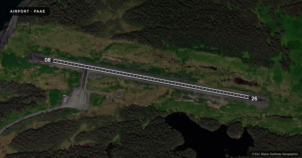
Airport sketch
Runways drawn to scale from FAA survey coordinates, rendered over satellite imagery. Not for navigation.
Approaches & charts
Services on the field
Fuel grades, oxygen, maintenance, ramp storage and lighting — as declared to the FAA by the airport operator.
Fuel & services
- Fuel
- Not available
Ramp & ground
- Transient storage
- Tie-down
- Lighting schedule
- SEE RMK
- Beacon schedule
- SS-SR
- Beacon
- White / Green (civil land)(WG)
- Wind indicator
- Yes
- Segmented circle
- Yes
Fuel & FBOs
Cheapest 100LL and Jet A on the field and nearby. Always confirm with the FBO before taxi.
Airport notes
Surface conditions, obstructions, local procedures, lighting outages and other notes published with each FAA cycle.
General notes
- RWY COND UNMNT; RCMD VISUAL INSP BFR LNDG.
- WX CAMERA AVBL ON INTERNET AT HTTPS://WEATHERCAMS.FAA.GOV
- BIRDS INVOF RWY.
Lighting notes
- ACTVT MIRL RWY 08/26 - CTAF.
VFR map & nearby airports
VFR sectional. Tap any ICAO chip to open that airport.
Key facts · PAAE
Answer card- ICAO
- PAAE
- Name
- OUZINKIE
- Location
- OUZINKIE, ALASKA
- Elevation
- 99.8 ft MSL
- Traffic pattern altitude
- 1,099.8 ft MSL (1,000 AGL)
- Control tower
- Non-towered (use CTAF)
- Total runways
- 1
- Longest runway
- 08/26 · 3,300 ft
- Published ILS approaches
- 0
- Published frequencies
- 1
- Magnetic variation
- 22°
- Current flight rules
- VFR
- Current wind
- 140° at 5 kt
- Favored runway now
- RWY 08
Ouzinkie Airport sits in Ouzinkie, Alaska. Field elevation is 99.8 ft MSL. The airport has one runway. Runway 08/26 is 3,300 ft long and gravel. That is the longest runway on the field.
There is no control tower. CTAF is 122.8. No ILS approaches are published here, so plan for non-precision or visual work only if conditions allow. The published pattern altitude is not listed in the facts block. For light piston operations, use the standard 1,000 ft AGL pattern unless the current Chart Supplement says otherwise.
Published remarks matter here. Runway condition is unmonitored, so a visual inspection before landing is smart. Birds are also reported in the vicinity of the runway. Medium intensity runway lights for 08/26 are activated by CTAF, which helps for night arrivals. There are no on-field FBOs listed, so verify fuel and services with the airport operator or the FBO directly by phone before you go. Pilots should also expect Alaska weather and coastal conditions to change quickly. Check the current Chart Supplement for any updates before departure.