METAR & TAF PACV
Current METAR
Observed 21:00Z
PACV 272100Z 24004KT 2SM BR OVC007 12/11 A2996 RMK AO2 RAE2057 CIG 005V010 P0000 T01220111
- Wind
- 240° @ 4 kt
- Visibility
- 2 SM
- Temp / Dew
- 12°C / 11°C
- Altimeter
- 29.96 inHg
- Clouds
- OVC
- Density alt
- -344 ft
- Ceiling
- 700 ft AGL
- Rules
- IFR
Airport info & contacts
Manager on record, flight service, ARTCC, attendance schedule and pattern altitude — published by the FAA and refreshed every 28 days.
Location
- From city
- 11 NM SE
- VFR sectional
- ANCHORAGE
- ARTCC
- ZAN · ANCHORAGE
- NOTAM facility
- CDV (NOTAM-D)
Airport manager
- Name
- MATTHEW MYSZKA
- Phone
- 907-424-3202
- Address
- BOX 598, CORDOVA AK 99574
Flight service · Hours
- FSS JNU
- JUNEAU907-586-73801-866-297-2236
- Attendance
- 0600-1630
Frequencies
Tap any row to copy the frequency to your clipboard.
Runways & pattern
Full pagePattern entry · RWY 27
LEFT TRAFFIC| Runway | Heading (°M) | Length | Surface | Traffic |
|---|---|---|---|---|
| 09/27Favored | 95° / 275° | 7,500 ft | ASPH | 09 R |
| 16/34 | 162° / 342° | 1,934 ft | GRVL | Standard L |
Runway end performance
| End | TORA | TODA | ASDA | LDA | VGSI | Approach lights | Obstruction |
|---|---|---|---|---|---|---|---|
| 09 | 7,500' | 7,500' | 7,500' | 7,500' | VASI 4-box left(3°) | ODALS | 20', ant, 600' from thr, 250' R of cntrln, slope 20 |
| 27 | 7,500' | 7,500' | 7,500' | 7,500' | VASI 4-box left(3°) | MALSR | 25', pole, 500' from thr, 450' R of cntrln, slope 12 |
| 34 | — | — | — | — | — | — | 70', trees, 350' from thr, 150' R of cntrln, slope 5 |
Declared distances in feet. TORA = takeoff run available, TODA = takeoff distance, ASDA = accelerate-stop, LDA = landing distance.
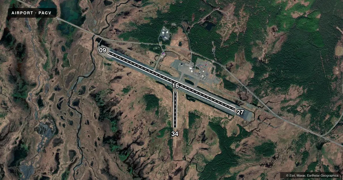
Airport sketch
Runways drawn to scale from FAA survey coordinates, rendered over satellite imagery. Not for navigation.
Approaches & charts
ILS · 1
Services on the field
Fuel grades, oxygen, maintenance, ramp storage and lighting — as declared to the FAA by the airport operator.
Fuel & services
- Fuel
- Not available
- Other services
- CARGO
Ramp & ground
- Transient storage
- Tie-down
- Landing fee
- No fee published
- Customs
- Not available
- Lighting schedule
- SEE RMK
- Beacon schedule
- SS-SR
- Beacon
- White / Green (civil land)(WG)
- Wind indicator
- Lighted
- Segmented circle
- Yes
Fuel & FBOs
Cheapest 100LL and Jet A on the field and nearby. Always confirm with the FBO before taxi.
Airport notes
Surface conditions, obstructions, local procedures, lighting outages and other notes published with each FAA cycle.
General notes
- ERRATIC WINDS.
- MOOSE & BIRDS INVOF ARPT & RWYS.
- ARFF EQUIP DURG ACR ACT ONLY.
- CORDOVA WX - 424-7614 OR 122.65.
- ARPT SAND LRGR GRADATION THAN FAA RCMDD/SEE AC150/5200-30.
- WX CAMERA AVBL ON INTERNET AT HTTPS://WEATHERCAMS.FAA.GOV
- TSA REGULATED ARPT; SEE 49 CFR 1542. GATES & DOORS MUST BE SECURED ALL TIMES; INFO - AMGR.
- ARPT SVCS & COND RPTG AVBL ONLY DURG MAINT DUTY HR; AFT HR - AMGR. BTN 1600 & 0700 SNOW REMOVAL & DEICE NA. RWY COND RPT REFLECTS DAY OPS ONLY.
Lighting notes
- ACTVT MALSR RWY 27; ODALS RWY 09; VASI RWYS 09 & 27; HIRL RWY 09/27 - CTAF.
Runway surface & condition
- 09/27PCR VALUE: 977/F/A/X/T
- 16/34RWY 16/34 NOT AVBL FOR PART 121/380 SKED AND NON-SKED OPS WITH PAX CARRYING OPS MORE THAN 30 PAX SEATS.
Approach & departure obstructions
- 1636 IN ORANGE CONES MAY 1 - OCT 25.
- 3436 IN ORANGE CONES MAY 1 - OCT 25.
- 09RWY 09 VASI UNUSBL BYD 4 NM DUE TO OBSTS.
Arresting gear
- 27_EMASENGINEERED MATERIALS ARRESTING SYSTEM (EMAS) 250 FT IN LENGTH BY 170 FT IN WIDTH LCTD DER 27.
Other notes
- CLSD TO ACR OPS MORE THAN 30 PAX SEATS EXC 24 HR PPR IN WRITING - AMGR BOX 598 CORDOVA AK 99574.
VFR map & nearby airports
VFR sectional. Tap any ICAO chip to open that airport.
Key facts · PACV
Answer card- ICAO
- PACV
- Name
- MERLE K (MUDHOLE) SMITH
- Location
- CORDOVA, ALASKA
- Elevation
- 53 ft MSL
- Traffic pattern altitude
- 1,053 ft MSL (1,000 AGL)
- Control tower
- Non-towered (use CTAF)
- Total runways
- 2
- Longest runway
- 09/27 · 7,500 ft
- Published ILS approaches
- 1
- Published frequencies
- 1
- Magnetic variation
- 19°
- Current flight rules
- IFR
- Current wind
- 240° at 4 kt
- Favored runway now
- RWY 27
Merle K (Mudhole) Smith Airport (PACV) is in Cordova, Alaska. Field elevation is 53 ft MSL. The airport has two runways. The longest is runway 09/27 at 7,500 ft. Runway 16/34 is 1,934 ft of gravel. There is no control tower. CTAF is 123.6.
The field has one ILS approach to runway 27. Runway 27 also has MALSR lighting. Runway 09 has ODALS and VASI. Runway 09/27 is lighted by high intensity runway lights that are controlled by CTAF. Pattern altitude is not published in the facts, so verify the current Chart Supplement before flying. The airport is TSA regulated. Gates and doors must stay secured. Contact the airport manager for access questions.
There are no on-field FBOs listed in the facts. FBO options vary. Contact the airport operator directly before arrival. Or call the field on CTAF for current FBO availability. First-time pilots should also plan for local weather and runway condition updates. Cordova weather is available by phone or on 122.65. Airport services and condition reporting are only available during maintenance duty hours. After hours, contact the airport manager. Snow removal and deice are not available between 1600 and 0700. Moose and birds are in the area. Keep a sharp scan on taxi, takeoff and landing.