METAR & TAF KTMB
Current METAR
Observed 12:53Z
KTMB 271253Z 23004KT 10SM FEW023 28/26 A2997 RMK AO2 LTG DSNT SW AND W SLP149 T02780256
- Wind
- 230° @ 4 kt
- Visibility
- 10 SM
- Temp / Dew
- 28°C / 26°C
- Altimeter
- 29.97 inHg
- Clouds
- FEW
- Density alt
- 1,510 ft
- Ceiling
- Unlimited
- Rules
- VFR
Airport info & contacts
Manager on record, flight service, ARTCC, attendance schedule and pattern altitude — published by the FAA and refreshed every 28 days.
Location
- From city
- 13 NM SW
- VFR sectional
- MIAMI
- ARTCC
- ZMA · MIAMI
- NOTAM facility
- TMB (NOTAM-D)
Airport manager
- Name
- HEIDI ANTHONY
- Phone
- 305-869-1702
- Address
- 12800 SW 145TH AVE, MIAMI FL 33186
Flight service · Hours
- FSS MIA
- MIAMI1-800-WX-BRIEF
- Attendance
- 0600-2100
Frequencies
Tap any row to copy the frequency to your clipboard.
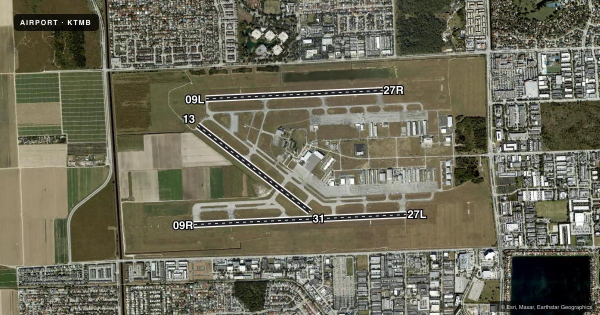
Runways & pattern
Full pagePattern entry · RWY 27L
LEFT TRAFFIC| Runway | Heading (°M) | Length | Surface | Traffic |
|---|---|---|---|---|
| 09R/27LFavored | 81° / 261° | 6,000 ft | ASPH | 09R R |
| 09L/27R | 81° / 261° | 5,003 ft | ASPH | 27R R |
| 13/31 | 121° / 301° | 4,001 ft | ASPH | Standard L |
Runway end performance
| End | TORA | TODA | ASDA | LDA | VGSI | Approach lights | Obstruction |
|---|---|---|---|---|---|---|---|
| 09R | — | — | — | — | PAPI 4-box right(3°) | MALSR | — |
| 27L | — | — | — | — | PAPI 4-box left(3°) | — | — |
| 09L | — | — | — | — | PAPI 4-box left(3°) | — | — |
| 27R | — | — | — | — | PAPI 2-box left(3°) | — | 85', tower, 4453' from thr, 100' R of cntrln, slope 50 |
| 13 | — | — | — | — | PAPI 4-box left(3°) | — | — |
| 31 | — | — | — | — | — | — | 29', pole, 1215' from thr, 250' R of cntrln, slope 36 |
Declared distances in feet. TORA = takeoff run available, TODA = takeoff distance, ASDA = accelerate-stop, LDA = landing distance.
Airport sketch
Runways drawn to scale from FAA survey coordinates, rendered over satellite imagery. Not for navigation.
Approaches & charts
ILS · 1
Services on the field
Fuel grades, oxygen, maintenance, ramp storage and lighting — as declared to the FAA by the airport operator.
Fuel & services
- Fuel
- 100LLA
- Oxygen (bottled)
- HIGH/LOW
- Oxygen (bulk)
- Low pressure
- Airframe repair
- Major
- Power plant repair
- Major
- Other services
- AMB,AVNCS,CHTR,INSTR,RNTL,SALES,SURV
Ramp & ground
- Transient storage
- Tie-down
- Hangar
- Landing fee
- No fee published
- Customs
- Not available
- Lighting schedule
- SEE RMK
- Beacon schedule
- SS-SR
- Beacon
- White / Green (civil land)(WG)
- Wind indicator
- Lighted
Fuel & FBOs
Cheapest 100LL and Jet A on the field and nearby. Always confirm with the FBO before taxi.
Airport notes
Surface conditions, obstructions, local procedures, lighting outages and other notes published with each FAA cycle.
General notes
- ARPT CLSD TO NON-ENG ACFT.
- BIRDS & AGRICULTURAL OPS BLW 200 FT AGL SR TO SS ON AND INVOF ARPT.
- PTNS OF TWY A BTN SPOTS 1 & 2 & PTNS OF TWY D BTN SPOTS 14 & 17 & PTNS OF TWY C BTN SPOTS 13 &14 NOT VSB FM ATCT. SIMUL MOV OF ACFT WITH WINGSPANS IN EXCESS OF 95 FT ARE PRECLUDED FM USING PARL TWY C AND TWY D.
- NOISE ABATEMENT PROC IN EFCT; NO TURNS BLW 1000 FT - 305-869-1700.
- NOISE SENSITIVE ARPT; FLT TRNG LTD WKDAY 1200-0400Z ; WKEND & OBSERVED HOL 1400-0200Z.
- FOR CD IF UNA TO CTC ON FSS FREQ, CTC MIAMI APCH AT 305-869-5432.
- US CBP AND EAPIS AVBL. 1500-0100Z++-305-969-7511. OPS. MNT FREQ 118.9 DURING CTAF OPS.
- US CBP EXTD HRS AVBL UPON REQ, EMAIL KTMB-ARRIVALS@CBP.DHS.GOV PRIOR TO 2300Z++.
- RWY 9L/27R AND RWY 13/31 CLSD DLY 0400-1200Z++ WHEN RWY 9R/27L IS IN USE.
- 24 HR PPR FOR ACFT EQUIPPED WITH WEATHER MODIFICATION OR GEOENGINEERING EQPT 305-869-1700.
Lighting notes
- WHEN ATCT CLSD ACTVT MALSR RWY 09R; HIRL RWY 09R/27L; MIRL RWY 13/31; TWY - CTAF.
Approach & departure obstructions
- 27RPAPI UNUSBL BYD 9 DEGS LEFT & 7 DEGS RIGHT OF CNTRLN.
Other notes
- US CBP 0900-2400 - 305-969-7511.
- HEL TFC PAT RWY 09R WI FIXED WING PAT AT OR BLW 500 FT AGL.
- CTC AMGR.
- OWNERCTC PERSON: LIONEL BECKLES, 305-876-7038.
VFR map & nearby airports
VFR sectional. Tap any ICAO chip to open that airport.
Key facts · KTMB
Answer card- ICAO
- KTMB
- Name
- MIAMI EXEC
- Location
- MIAMI, FLORIDA
- Elevation
- 10 ft MSL
- Traffic pattern altitude
- 1,010 ft MSL (1,000 AGL)
- Control tower
- Towered · 0700-2300
- Total runways
- 3
- Longest runway
- 09R/27L · 6,000 ft
- Published ILS approaches
- 1
- Published frequencies
- 8
- Magnetic variation
- 6°
- Current flight rules
- VFR
- Current wind
- 230° at 4 kt
- Favored runway now
- RWY 27L
Miami Executive Airport sits in Miami, Florida at 10 ft MSL. It has three asphalt runways. The longest is 09R/27L at 6,000 ft. The field is towered from 0700 to 2300. One ILS is published for runway 09R. Pattern altitude is not published in the facts. Use the standard 1,000 ft AGL for light piston traffic unless ATC or the current Chart Supplement says otherwise.
This is a busy South Florida field. Noise abatement is in effect. No turns below 1,000 ft. The airport is closed to non-engine aircraft. Birds and agricultural activity are reported below 200 ft AGL from sunrise to sunset in and near the airport. Taxiway visibility limits also matter here. Some portions of taxiways A, C and D are not visible from the tower. Operations with wingspans over 95 ft cannot use parallel taxiways C and D together.
On the field, International Flight Center - North, International Flight Center, Signature Aviation and Reliance Aviation all carry 100LL. Jet A is available at each of those FBOs. Jet A Prist is listed at International Flight Center - North, International Flight Center and Reliance Aviation. When the tower is closed, runway and taxiway lighting procedures change. Check the current Chart Supplement before departure if you need the exact lighting steps or any customs details.