METAR & TAF KSCK
Current METAR
Observed 15:55Z
KSCK 271555Z VRB03KT 10SM CLR 22/11 A2998 RMK AO2 SLP151 T02170111 $
- Wind
- VAR @ 3 kt
- Visibility
- 10 SM
- Temp / Dew
- 22°C / 11°C
- Altimeter
- 29.98 inHg
- Clouds
- CLR
- Density alt
- 806 ft
- Ceiling
- Unlimited
- Rules
- VFR
Airport info & contacts
Manager on record, flight service, ARTCC, attendance schedule and pattern altitude — published by the FAA and refreshed every 28 days.
Location
- From city
- 3 NM SE
- VFR sectional
- SAN FRANCISCO
- ARTCC
- ZOA · OAKLAND
- NOTAM facility
- SCK (NOTAM-D)
Airport manager
- Name
- RICHARD SOKOL
- Phone
- 209-468-4700
- Address
- 5000 S. AIRPORT WAY ROOM 202, STOCKTON CA 95206
Flight service · Hours
- FSS RIU
- RANCHO MURIETA1-800-WX-BRIEF
- Attendance
- 0500-2100
Frequencies
Tap any row to copy the frequency to your clipboard.
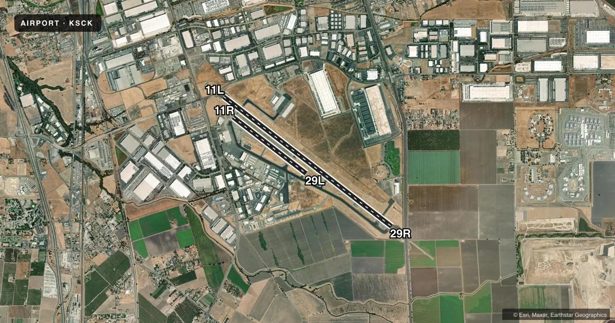
Runways & pattern
Full pagePattern entry · RWY 29R
RIGHT TRAFFIC| Runway | Heading (°M) | Length | Surface | Traffic |
|---|---|---|---|---|
| 11L/29RFavored | 114° / 294° | 10,245 ft | ASPH | 29R R |
| 11R/29L | 114° / 294° | 4,448 ft | ASPH | 11R R |
Runway end performance
| End | TORA | TODA | ASDA | LDA | VGSI | Approach lights | Obstruction |
|---|---|---|---|---|---|---|---|
| 11L | 8,481' | 9,481' | 8,611' | 8,650' | PAPI 4-box left(3°) | — | — |
| 29R | 8,857' | 9,857' | 9,210' | 8,650' | PAPI 4-box left(3°) | MALSR | — |
| 11R | 4,448' | 4,448' | 4,448' | 4,448' | — | — | — |
| 29L | 4,448' | 4,448' | 4,448' | 3,385' | — | — | — |
Declared distances in feet. TORA = takeoff run available, TODA = takeoff distance, ASDA = accelerate-stop, LDA = landing distance.
Airport sketch
Runways drawn to scale from FAA survey coordinates, rendered over satellite imagery. Not for navigation.
Approaches & charts
ILS · 1
Services on the field
Fuel grades, oxygen, maintenance, ramp storage and lighting — as declared to the FAA by the airport operator.
Fuel & services
- Fuel
- 100100LLA
- Oxygen (bottled)
- High pressure
- Oxygen (bulk)
- High pressure
- Airframe repair
- Major
- Power plant repair
- Major
- Other services
- CHTR,INSTR,RNTL,SALES
Ramp & ground
- Transient storage
- Hangar
- Landing fee
- Yes
- Customs
- Not available
- Lighting schedule
- SEE RMK
- Beacon schedule
- SS-SR
- Beacon
- White / Green (civil land)(WG)
- Wind indicator
- Lighted
- Segmented circle
- Yes
Fuel & FBOs
Cheapest 100LL and Jet A on the field and nearby. Always confirm with the FBO before taxi.
Airport notes
Surface conditions, obstructions, local procedures, lighting outages and other notes published with each FAA cycle.
General notes
- SEAGULLS ON AND IN VCNTY OF ARPT MOSTLY DURING RAINY WEATHER.
- AVOID OVERFLYING SAN JOAQUIN GENERAL HOSPITAL & THE CITY OF MANTECA.
- ARPT CLSD TO TGL & PLANNED LOW APCHS FOR TURBOJET ACFT 2200-0700 EXCEPT BY PPR FM AMGR PART 36 STAGE 3 ACFT.
- PRACTICE CIRCLING APPROACHES TO RWYS 11L/11R NA FOR ANY TURBINE POWERED ACFT/PROP DRIVEN ACFT EXCEEDING 12500 LBS EXCP BY PPR FM AMGR.
- MILITARY USE: ARNG OPR 1500-2330Z++ MON-FRI. DSN 466-5319, C209-983-5319, FAX 5391. PPR REQUIRED. LDTD TRAN SVC AND MAINT AVBL FOR CH47.
- THE FLWG AREAS NOT VISIBLE FM ATCT: TWY B FM TRML APN TO INT AT TWY M; TWY B FM 300 FT W OF TWY J TO 375 FT E OF TWY J; NON MOVEMENT AREA S OF TWY B FROM TRML APN TO 200 FT W OF TWY H; SE HALF OF TRML APN; TSNT PRKG APN.
- TRANSIENT PARKING AVBL AT FBO.
- BE ALERT TO ELEVD MALSR APCH END RWY 29R LCTD ON BLAST PAD.
- TRML APN, CARGO APN, TWYS B, B2, B3, F, D, D7, D9, AND H FOR ACFT OVER 12500 LBS. ALL OTR TWYS RSTRD TO ACFT LESS THAN 12500 LBS.
- PAVEMENT PRIOR TO THLD OF RWY 11L NOT AVBL FOR TAXI BACK OPS.
- FOR CD WHEN ATCT CLSD CTC NORCAL APCH AT 916-361-0516.
- TSNT PILOTS USE CTN; DO NOT ENTER THE TSA RSTRD AREA ADJ TO THE TSNT PRKG AREA.
- TWY F RSTRD TO ACFT WINGSPAN LESS THAN 118 FT.
Lighting notes
- ACTVT HIRL RY 11L/29R, PAPI RY 11L AND RY 29R, MALSR RY 29R - CTAF.
Fuel notes
- 100FUEL & SVC 0500-2100; OTHER TIMES CALL (209) 982-1622 - SVC CHARGE.
Runway surface & condition
- 11L/29RPCR VALUE: 579/F/D/X/T
- 11R/29LPCR VALUE: 213/F/C/X/T
- 11R/29LRWY 11R/29L NOT AVBL FOR PART 121/PART 380 OPS WITH SKED PAX CARRYING OPS MORE THAN 9 PAX SEATS AND NON-SKED PAX CARRYING OPS MORE THAN 30 PAX SEATS.
Approach & departure obstructions
- 29RUNUSBL BYD 9 DEGS RIGHT OF CNTRLN.
Other notes
- CLSD TO UNSKED ACR OPNS WITH MORE THAN 30 PSGR SEATS EXCP ONE HR PPR, CALL AMGR (209) 468-4700 OR 4722; AFTER HRS CALL (209) 468-4722. RWY 11R/29L NOT AVBL FOR SKED ACR OPNS WITH MORE THAN 9 PSGR SEATS OR UNSKED ACR AT LEAST 31 PSGR SEATS.
- LNDG FEE FOR ACFT OVER 12500 LBS.
VFR map & nearby airports
VFR sectional. Tap any ICAO chip to open that airport.
Key facts · KSCK
Answer card- ICAO
- KSCK
- Name
- STOCKTON METRO
- Location
- STOCKTON, CALIFORNIA
- Elevation
- 32.6 ft MSL
- Traffic pattern altitude
- 1,032.6 ft MSL (1,000 AGL)
- Control tower
- Towered · 0700-2100
- Total runways
- 2
- Longest runway
- 11L/29R · 10,245 ft
- Published ILS approaches
- 1
- Published frequencies
- 15
- Magnetic variation
- 14°
- Current flight rules
- VFR
- Current wind
- 000° at 3 kt
- Favored runway now
- RWY 29R
Stockton Metro Airport sits in Stockton, California. Field elevation is 32.6 ft MSL. The airport has two asphalt runways. The longest is 11L/29R at 10,245 ft. The control tower is open daily from 0700 to 2100. One ILS is published for runway 29R.
Pattern altitude is not published in the facts, so use the standard 1,000 ft AGL for light piston traffic unless the current FAA Chart Supplement says otherwise. Atlantic Aviation is on the field. It carries 100LL and Jet A. Fuel and service are available from 0500 to 2100. Call ahead after hours.
This is a busy field with several operational limits to keep in mind. Tower visibility is limited over parts of taxiway B, the southeast half of the terminal apron and the transient parking apron. Taxiway F is restricted to aircraft with wingspan under 118 ft. Avoid overflying San Joaquin General Hospital and the city of Manteca. The airport also has restrictions for large passenger operations. Turbojet touch-and-go or low approach work overnight is also restricted. Check the current FAA Chart Supplement before flying in if you need any of those details. The field sits close to sea level, so density altitude is usually not the main issue. Traffic flow, runway selection and local restrictions matter more here.