METAR & TAF KSAT
Current METAR
Observed 07:51Z
KSAT 280751Z 17007KT 10SM BKN017 26/22 A2991 RMK AO2 SLP108 T02560222
- Wind
- 170° @ 7 kt
- Visibility
- 10 SM
- Temp / Dew
- 26°C / 22°C
- Altimeter
- 29.91 inHg
- Clouds
- BKN
- Density alt
- 2,336 ft
- Ceiling
- 1,700 ft AGL
- Rules
- MVFR
Airport info & contacts
Manager on record, flight service, ARTCC, attendance schedule and pattern altitude — published by the FAA and refreshed every 28 days.
Location
- From city
- 7 NM N
- VFR sectional
- SAN ANTONIO
- ARTCC
- ZHU · HOUSTON
- NOTAM facility
- SAT (NOTAM-D)
Airport manager
- Name
- JESUS H. SAENZ, JR.
- Phone
- 210-207-3444
- Address
- 9800 AIRPORT BLVD, SAN ANTONIO TX 78216
Flight service · Hours
- FSS SJT
- SAN ANGELO1-800-WX-BRIEF
- Attendance
- ALL
Frequencies
Tap any row to copy the frequency to your clipboard.
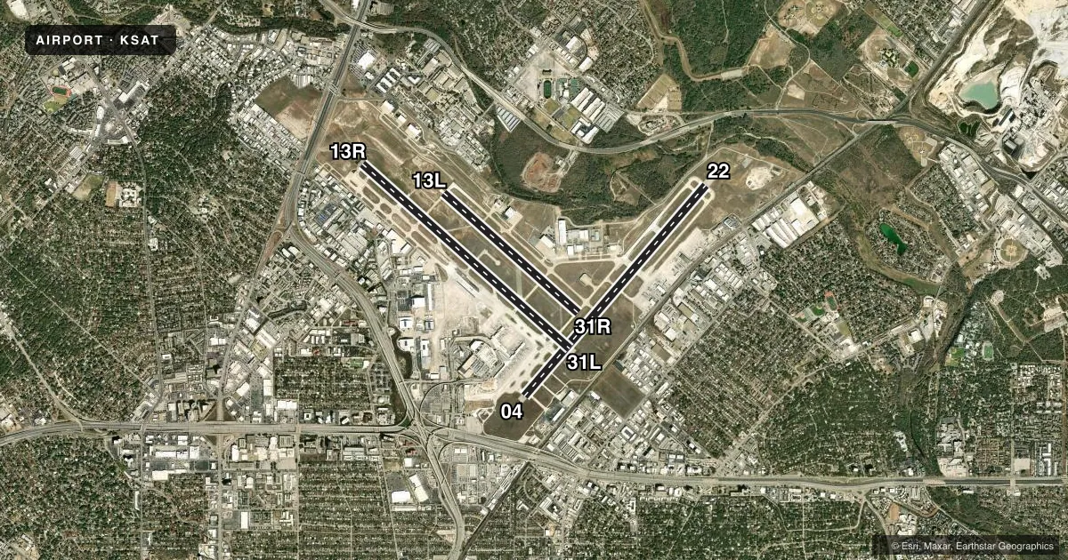
Runways & pattern
Full pagePattern entry · RWY 13R
LEFT TRAFFIC| Runway | Heading (°M) | Length | Surface | Traffic |
|---|---|---|---|---|
| 04/22 | 37° / 217° | 8,505 ft | CONC | Standard L |
| 13R/31LFavored | 128° / 308° | 8,502 ft | CONC | Standard L |
| 13L/31R | 128° / 308° | 5,519 ft | ASPH | Standard L |
Runway end performance
| End | TORA | TODA | ASDA | LDA | VGSI | Approach lights | Obstruction |
|---|---|---|---|---|---|---|---|
| 04 | 8,505' | 8,505' | 8,505' | 8,505' | PAPI 4-box right(3°) | MALS | 46', pole, 2180' from thr, 225' R of cntrln, slope 43 |
| 22 | 8,505' | 8,505' | 8,505' | 8,505' | PAPI 4-box left(3°) | — | — |
| 13R | 8,502' | 8,502' | 8,502' | 8,502' | PAPI 4-box left(3°) | ALSF2 | — |
| 31L | 8,502' | 8,502' | 8,502' | 8,502' | PAPI 4-box left(3°) | MALSR | 79', bldg, 3500' from thr, 300' R of cntrln, slope 41 |
| 13L | 5,519' | 5,519' | 5,519' | 5,519' | PAPI 4-box left(3°) | — | — |
| 31R | 5,519' | 5,519' | 5,519' | 5,519' | PAPI 4-box left(3°) | — | — |
Declared distances in feet. TORA = takeoff run available, TODA = takeoff distance, ASDA = accelerate-stop, LDA = landing distance.
Airport sketch
Runways drawn to scale from FAA survey coordinates, rendered over satellite imagery. Not for navigation.
Approaches & charts
ILS · 3
Services on the field
Fuel grades, oxygen, maintenance, ramp storage and lighting — as declared to the FAA by the airport operator.
Fuel & services
- Fuel
- 100LLA
- Oxygen (bottled)
- HIGH/LOW
- Oxygen (bulk)
- HIGH/LOW
- Airframe repair
- Major
- Power plant repair
- Major
- Other services
- AVNCS,CARGO,CHTR,INSTR,RNTL,SALES
Ramp & ground
- Transient storage
- Tie-down
- Hangar
- Landing fee
- Yes
- Customs
- Not available
- Lighting schedule
- SS-SR
- Beacon schedule
- SS-SR
- Beacon
- White / Green (civil land)(WG)
- Wind indicator
- Lighted
- Segmented circle
- No
Fuel & FBOs
Cheapest 100LL and Jet A on the field and nearby. Always confirm with the FBO before taxi.
Airport notes
Surface conditions, obstructions, local procedures, lighting outages and other notes published with each FAA cycle.
General notes
- TWY L CLSD NORTHBOUND.
- NUMEROUS FLOCKS OF BIRDS INVOF ARPT.
- GLIDER/SOARING OPNS APRXLY 17 MILES NW OF ARPT DURG VFR.
- NOISE SENSITIVE AREAS EXIST ON ALL SIDES OF ARPT, AT PILOTS DISCRETION CLIMB AS QUICKLY AND QUIETLY AS SAFELY POSSIBLE ON DEPARTURE AND USE CONSIDERATION WHEN FLYING OVER POPULATED AREAS BY MINIMIZING FLT AND HIGH PWR SETTINGS. MILITARY AIRCRAFT: DEPARTING AND ARRIVING AIRCRAFT WILL USE MINIMUM POWER SETTINGS CONSISTENT WITH AIRCRAFT FLIGHT MANUALS, AFTERBURNER TAKEOFF IS PROHIBITED UNLESS REQUIRED FOR SAFETY OF FLIGHT. ENGINE-UPS ARE PERMITTED BTN 0600-2300.
- ACFT TAXIING ON RY 04 NE BOUND LOOK FOR HOLD SHORT TO RY 31L.
- ACFT TAXIING ON TWY N SW BOUND LOOK FOR HOLD SHORT TO RY 31R.
- GROUND RUN-UP ENCLOSURE AVBL 24 HRS.
- TERMINAL GATES A2, A6, A7, A8, USE ONLY WITH PPR CALL OPNS 210-413-4928.
- THE FLWG TWYS ARE NOT AVBL FOR ACFT 59000 LBS OR OVR: TWY A, TWY M, TWY H NORTHWEST OF TWY Z AND TWY E EAST OF RWY 04/22.
- TWY Z CLSD TO ACFT WITH WINGSPAN GREATER THAN 118 FT.
- C130 AND C17 TYPE ACFT MUST PARK ON WEST RAMP TO CLR CUST.
- INNER RAMP TAXILANE NORTH OF TRML A AND B IS CLSD TO ACFT WITH WINGSPAN GTR THAN 135 FT.
- PPR WITH ARPT OPNS FOR ACFT POWERING BACK FM TERMINAL GATES.
- TWYS L & B CLSD TO ACFT WITH WINGSPANS GREATER THAN 118 FT EXITING RY 31L.
- ACFT AT TERMINAL A & B ADVISE GND CTL PRIOR TO PUSH.
- ARPT RSTD TO ACFT WITH WINGSPAN GTR THAN 171 FT, PPR WITH 24HR OPS 210-413-4928. RQRD FOR AUTH.
- APRON EAST CARGO RAMP INT OF RWY 04/22 AND TWY DELTA ACFT ARE REQ TO APPLY THE MNM THRUST WHEN XNG THE RWY TO AVOID DMG DUE TO JET BLAST.
- ALL INTL GENERAL AVIATION CLEAR U.S. CSTMS AT NORTH FIXED BASE OPERATOR RAMP EAST SIDE, CALL U.S. CSTMS 210-821-6965 UPON ARR.
- FOREIGN MIL ACFT WITH WINGSPAN LESS THAN 100 FT MUST REP TO GA RAMP FED INSPECTION STATION FOR CUST PROCESSING, CTC AP MANAGEMENT AT 210-207-3433.
Runway surface & condition
- 04/22PCR VALUE: 950/R/B/W/T
- 13L/31RPCR VALUE: 570/F/C/X/T
- 13R/31LPCR VALUE: 810/R/B/W/T
- 13L/31RRWY 13L/31R NOT AVBL FOR PART 121/PART 380 OPS WITH SKED PAX CARRYING OPS MORE THAN 9 PAX SEATS AND NON-SKED PAX CARRYING OPS MORE THAN 30 PAX SEATS.
Other notes
- SAT IS ARFF INDEX C; ARFF INDEX D AVBL WITH PPR.
- 13R/31LRUNWAY HAS MET ITS SERVICE LIFE CYCLE AND IS IN NEED OF OVERHAUL.
VFR map & nearby airports
VFR sectional. Tap any ICAO chip to open that airport.
Key facts · KSAT
Answer card- ICAO
- KSAT
- Name
- SAN ANTONIO INTL
- Location
- SAN ANTONIO, TEXAS
- Elevation
- 809.1 ft MSL
- Traffic pattern altitude
- 1,809.1 ft MSL (1,000 AGL)
- Control tower
- Towered · 24
- Total runways
- 3
- Longest runway
- 04/22 · 8,505 ft
- Published ILS approaches
- 3
- Published frequencies
- 31
- Magnetic variation
- 4°
- Current flight rules
- MVFR
- Current wind
- 170° at 7 kt
- Favored runway now
- RWY 13R
San Antonio Intl is in San Antonio, Texas. The field elevation is 809.1 ft MSL. It has three runways. The longest is 8,505 ft. Tower service is available 24 hours. Three ILS approaches are published for runway ends 04, 13R and 31L.
Pattern altitude is not published in the facts, so use the standard 1,000 ft AGL for light piston traffic unless ATC or the current Chart Supplement says otherwise. The airport sits inside Class C airspace. Expect a busy arrival and departure flow. Noise-sensitive areas surround the airport on all sides. Plan a clean climb. Keep power changes modest over populated areas.
On field, Signature Aviation - South carries 100LL and Jet A. Million Air carries 100LL, Jet A and Jet A Prist. Skyplace carries 100LL, Jet A and Jet A Prist. Signature Aviation - North carries 100LL and Jet A. A few operational notes matter here. Runway 04 taxiing northeast bound may come with hold short instructions for 31L. Taxiway N southwest bound may also come with hold short instructions for 31R. Birds are reported in the area. Keep a sharp scan on departure and arrival.