METAR & TAF KSAD
Current METAR
Observed 18:51Z
KSAD 271851Z AUTO 29015G26KT 10SM CLR 39/14 A2998 RMK AO2 PK WND 27030/1818 SLP081 T03940144
- Wind
- 290° @ 15G26 kt
- Visibility
- 10 SM
- Temp / Dew
- 39°C / 14°C
- Altimeter
- 29.98 inHg
- Clouds
- CLR
- Density alt
- 6,747 ft
- Ceiling
- Unlimited
- Rules
- VFR
Airport info & contacts
Manager on record, flight service, ARTCC, attendance schedule and pattern altitude — published by the FAA and refreshed every 28 days.
Location
- From city
- 3 NM E
- VFR sectional
- PHOENIX
- ARTCC
- ZAB · ALBUQUERQUE
- NOTAM facility
- SAD (NOTAM-D)
Airport manager
- Name
- CAMERON ATKINS
- Phone
- 928-432-4235
- Address
- 4428 E AVIATION WAY, SAFFORD AZ 85546-0272
Flight service · Hours
- FSS PRC
- PRESCOTT1-800-WX-BRIEF
- Attendance
- MON-SAT · 0700-1800
Frequencies
Tap any row to copy the frequency to your clipboard.
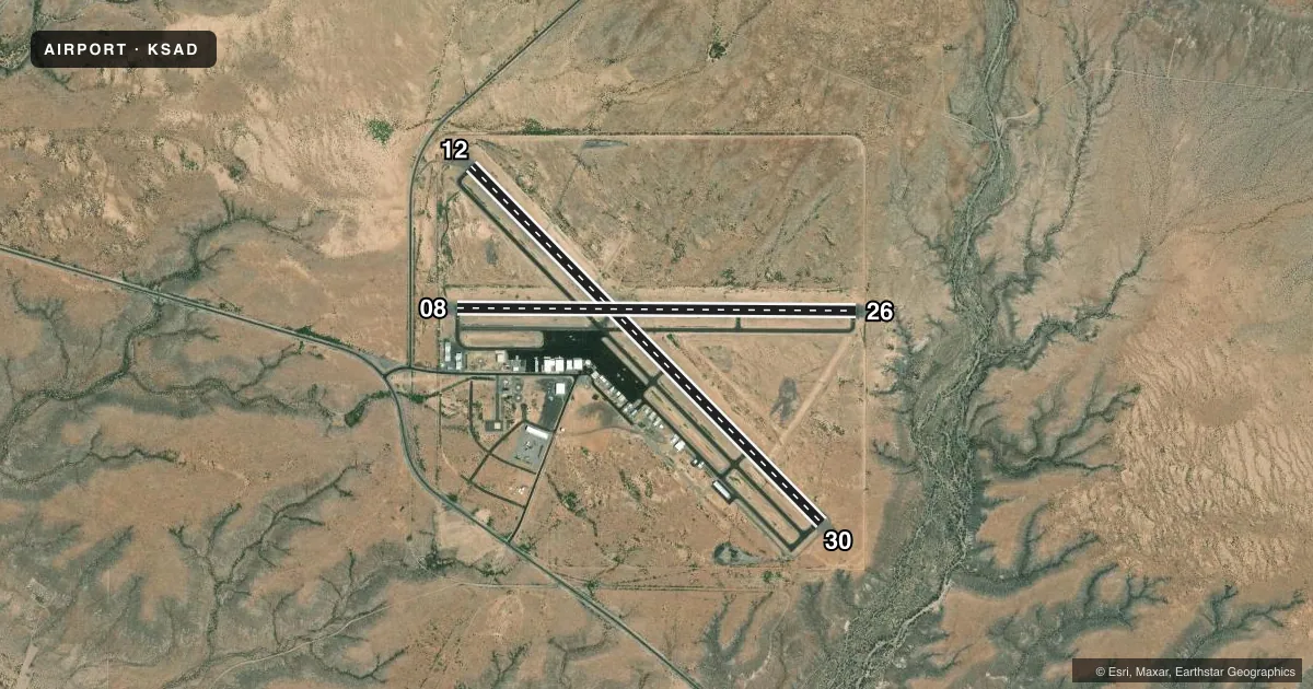
Runways & pattern
Full pagePattern entry · RWY 26
LEFT TRAFFIC| Runway | Heading (°M) | Length | Surface | Traffic |
|---|---|---|---|---|
| 12/30 | 123° / 303° | 6,007 ft | ASPH | Standard L |
| 08/26Favored | 78° / 258° | 4,802 ft | ASPH | Standard L |
Runway end performance
| End | TORA | TODA | ASDA | LDA | VGSI | Approach lights | Obstruction |
|---|---|---|---|---|---|---|---|
| 12 | — | — | — | — | PAPI 2-box left(3°) | — | — |
| 30 | — | — | — | — | PAPI 2-box left(3°) | — | — |
| 08 | — | — | — | — | PAPI 2-box left(3°) | — | — |
| 26 | — | — | — | — | PAPI 2-box left(3°) | — | — |
Declared distances in feet. TORA = takeoff run available, TODA = takeoff distance, ASDA = accelerate-stop, LDA = landing distance.
Airport sketch
Runways drawn to scale from FAA survey coordinates, rendered over satellite imagery. Not for navigation.
Approaches & charts
Services on the field
Fuel grades, oxygen, maintenance, ramp storage and lighting — as declared to the FAA by the airport operator.
Fuel & services
- Fuel
- 100LLA+
- Oxygen (bottled)
- HIGH/LOW
- Oxygen (bulk)
- HIGH/LOW
- Airframe repair
- Major
- Power plant repair
- Major
- Other services
- AFRT,AMB,AVNCS,CARGO,CHTR,INSTR,RNTL,SURV
Ramp & ground
- Transient storage
- Tie-down
- Hangar
- Landing fee
- Yes
- Customs
- Not available
- Lighting schedule
- SEE RMK
- Beacon schedule
- SS-SR
- Beacon
- White / Green (civil land)(WG)
- Wind indicator
- Lighted
- Segmented circle
- Yes
Fuel & FBOs
Cheapest 100LL and Jet A on the field and nearby. Always confirm with the FBO before taxi.
Airport notes
Surface conditions, obstructions, local procedures, lighting outages and other notes published with each FAA cycle.
General notes
- MIL ACT INVOF ARPT.
- FOR CD IF UNA TO CTC ON FSS FREQ, CTC ALBUQUERQUE ARTCC AT 505-856-4561.
- LNDG FEE OVR 4000 LB MTOW; MIL/GOV/CHARITY WAIVED OR WITH FUEL PURCHASE.
Lighting notes
- ACTVT REIL RWY 08, 12, 26 & 30; PAPI RWY 08, 12, 26, & 30; MIRL RWY 08/26 & RWY 12/30 - CTAF.
Fuel notes
- 100LLH24 WITH CREDIT CARD.
Other notes
- ESTABD PRIOR TO 5/15/59.
- ARFF INDEX B.
- PPR.
- 1AFT HR; CALL OUT FEE - 928-432-4237.
- MANAGEREMERG - 928-432-4237
VFR map & nearby airports
VFR sectional. Tap any ICAO chip to open that airport.
Key facts · KSAD
Answer card- ICAO
- KSAD
- Name
- SAFFORD RGNL/1LT DUANE SPALSBURY FLD
- Location
- SAFFORD, ARIZONA
- Elevation
- 3,178.4 ft MSL
- Traffic pattern altitude
- 4,178.4 ft MSL (1,000 AGL)
- Control tower
- Non-towered (use CTAF)
- Total runways
- 2
- Longest runway
- 12/30 · 6,007 ft
- Published ILS approaches
- 0
- Published frequencies
- 2
- Magnetic variation
- 12°
- Current flight rules
- VFR
- Current wind
- 290° at 15 kt
- Favored runway now
- RWY 26
Safford Rgnl/1LT Duane Spalsbury Fld sits in Safford, Arizona. Field elevation is 3,178.4 ft MSL. The airport has two asphalt runways. The longest is 6,007 ft on runway 12/30. Runway 08/26 is 4,802 ft. There is no control tower. CTAF and UNICOM are both 122.8.
No ILS approaches are published here. Pattern altitude is not published in the facts. Use the standard 1,000 ft AGL for light piston operations unless the current FAA Chart Supplement says otherwise. Spalsbury Aviation is on the field. It carries 100LL, Jet A and Jet A Prist. 100LL is available 24 hours with credit card. After hours service is available with a call out fee. Call 928-432-4237 for the field or for the emergency number.
A few operational items matter here. Military activity is in the vicinity of the airport. Aircraft rescue and fire fighting index B is available. Landing fees apply for aircraft over 4,000 pounds maximum takeoff weight. Military, government and charity aircraft are waived or exempt with fuel purchase. Prior permission is required for transient storage and hangar. Runway end identifier lights, PAPI and medium intensity runway lights are available on both runways. The lights are controlled by CTAF. If you need clearance delivery and cannot reach Flight Service, contact Albuquerque ARTCC at 505-856-4561.