METAR & TAF KRIC
Current METAR
Observed 15:54Z
KRIC 271554Z 02006KT 8SM FEW010 FEW110 SCT250 27/19 A2987 RMK AO2 SLP117 T02720194
- Wind
- 020° @ 6 kt
- Visibility
- 8 SM
- Temp / Dew
- 27°C / 19°C
- Altimeter
- 29.87 inHg
- Clouds
- SCT
- Density alt
- 1,710 ft
- Ceiling
- Unlimited
- Rules
- VFR
Airport info & contacts
Manager on record, flight service, ARTCC, attendance schedule and pattern altitude — published by the FAA and refreshed every 28 days.
Location
- From city
- 6 NM E
- VFR sectional
- WASHINGTON
- ARTCC
- ZDC · WASHINGTON
- NOTAM facility
- RIC (NOTAM-D)
Airport manager
- Name
- PERRY J. MILLER
- Phone
- 804-226-0001
- Address
- 1 RICHARD E BYRD TERMINAL DR, RICHMOND VA 23250
Flight service · Hours
- FSS DCA
- LEESBURG1-800-WX-BRIEF
- Attendance
- ALL
Frequencies
Tap any row to copy the frequency to your clipboard.
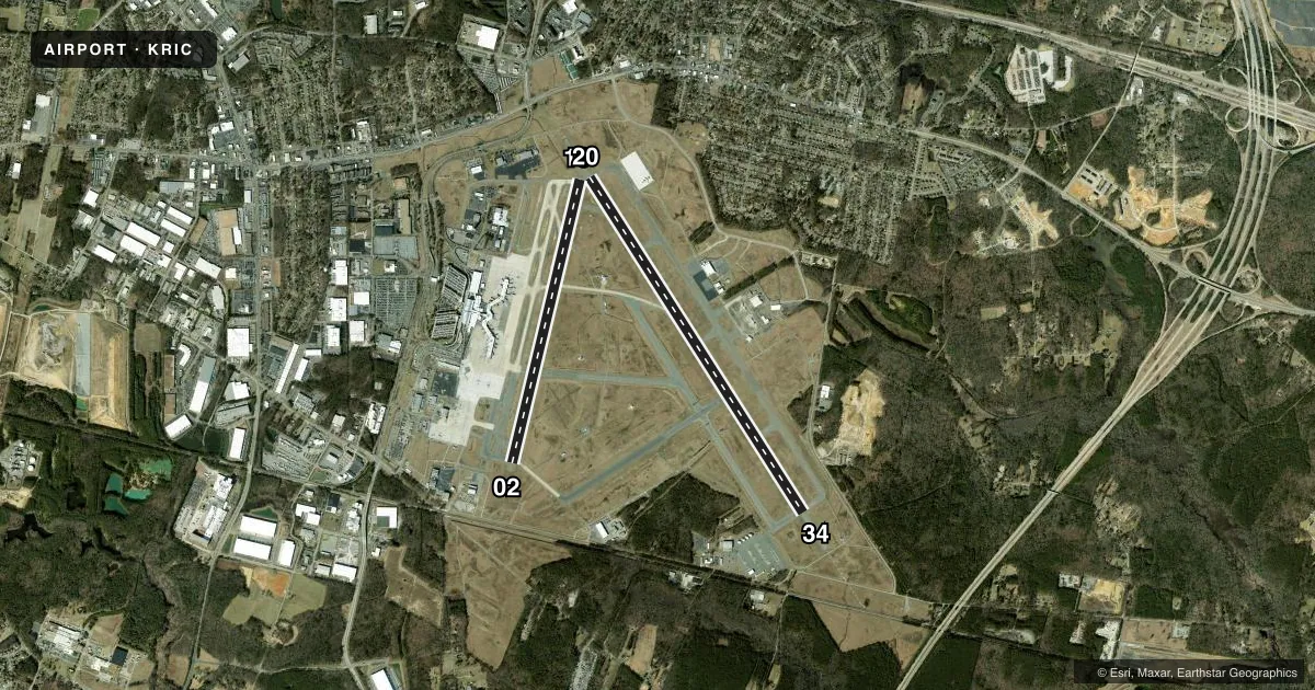
Runways & pattern
Full pagePattern entry · RWY 02
LEFT TRAFFIC| Runway | Heading (°M) | Length | Surface | Traffic |
|---|---|---|---|---|
| 16/34 | 137° / 317° | 9,003 ft | ASPH | Standard L |
| 02/20Favored | 3° / 183° | 6,607 ft | ASPH | Standard L |
Runway end performance
| End | TORA | TODA | ASDA | LDA | VGSI | Approach lights | Obstruction |
|---|---|---|---|---|---|---|---|
| 16 | 9,003' | 9,003' | 9,003' | 9,003' | PAPI 4-box left(3°) | MALSR | — |
| 34 | 9,003' | 9,003' | 9,003' | 9,003' | PAPI 4-box left(3°) | ALSF2 | — |
| 02 | 6,607' | 6,607' | 6,607' | 6,607' | PAPI 4-box left(3°) | MALSR | 90', pole, 3300' from thr, 450' R of cntrln, slope 34 |
| 20 | 6,607' | 6,607' | 6,607' | 6,607' | PAPI 4-box left(3°) | — | 67', tree, 2400' from thr, 650' R of cntrln, slope 33 |
Declared distances in feet. TORA = takeoff run available, TODA = takeoff distance, ASDA = accelerate-stop, LDA = landing distance.
Airport sketch
Runways drawn to scale from FAA survey coordinates, rendered over satellite imagery. Not for navigation.
Approaches & charts
ILS · 3
Services on the field
Fuel grades, oxygen, maintenance, ramp storage and lighting — as declared to the FAA by the airport operator.
Fuel & services
- Fuel
- 100LLA
- Oxygen (bottled)
- HIGH/LOW
- Oxygen (bulk)
- Not available
- Airframe repair
- Major
- Power plant repair
- Major
- Other services
- CARGO,CHTR,INSTR
Ramp & ground
- Transient storage
- Tie-down
- Hangar
- Landing fee
- Yes
- Customs
- Not available
- Lighting schedule
- SS-SR
- Beacon schedule
- SS-SR
- Beacon
- White / Green (civil land)(WG)
- Wind indicator
- Lighted
- Segmented circle
- No
Fuel & FBOs
Cheapest 100LL and Jet A on the field and nearby. Always confirm with the FBO before taxi.
Airport notes
Surface conditions, obstructions, local procedures, lighting outages and other notes published with each FAA cycle.
General notes
- NO TURBOJET ACFT PRACTICE LDGS 2200-0700.
- BIRD ACT INVOF ALL RWYS & TWYS & INVOF ARPT.
- ACR APRON CLSD TO UNSKED ACFT WEIGHING UNDER 35000 LBS.
- NO EDGE LGTS ON N/S SECTION OF TWY V - REFLECTORS ONLY.
- HOLD LINE RWY 20 EAST SIDE LCTD ACROSS RWY 34 150 FT FM DEP END. HOLD LINE RWY 20 WEST SIDE ACROSS TWY A & ALSO SERVES AS HOLD LINE FOR RWY 16; SIGNAGE INDICATES BOTH RWYS.
- NON-RDO EQUIPPED VEHICLES CROSSING MIDFIELD TWYS C, E AND H AND DRIVING ON TWY L.
- THE FOLLOWING AREAS ARE NOT VISIBLE FROM THE TWR: PORTIONS OF THE ACR APRON; ANG ACFT PRKG RAMP.
- DUE TO THE CLOSE PROXIMITY TO RWY 02/20, TWY UNIFORM SIGNAGE MAY BE BEHIND ACFT, ONCE CLEAR OF RWY 02/20.
- RIC HAS FACILITY CONSTRAINTS THAT LIMIT ITS ABILITY TO ACCOMMODATE DIVERTED FLTS AND STRONGLY ENCOURAGES ACFT OPRS TO CTC ARPT OPNS AT 804-226-0001 FOR PRIOR CDN OF DIVERTED FLTS, EXCEPT IN THE CASE OF A DECLARED IN-FLIGHT EMERG.
- TWY V BTN TWY A & TWY R RSTRD FM USE BY ACFT WITH WINGSPANS GREATER THAN 99 FT.
- NO TAXIING BTN PUSHED BACK ACFT AND THE TRML ON THE ACR RAMP.
- DUE TO OPR CONSTRAINTS ACFT PUSHED BACK FOR DEP PROHIBITED FM HLDG ON ACR RAMPS FOR MORE THAN 5 MINS.
- CONS CONST ON ARPT; BE ALERT FOR FREQ RWY & TWY CLOSURES.
- ATC CLNC RQRD FOR PUSHBACKS FROM GATES A6, A8, A10, A12, A14, B5, B7, B9, B11, B13 ONTO TWY A.
- ATC CLNC RQRD FOR PUSHBACK FROM HARDSTANDS C9, C10 AND C12 ONTO TWY T.
- ARPT SFC COND NOT MNTD 0000 TO 0600 LCL TIME.
- FOR AIRFIELD INFO OR ARPT OPNS CALL 804-226-0001.
Runway surface & condition
- 02/20PCR VALUE: 820/F/C/X/T
- 16/34PCR VALUE: 600/F/B/X/T
Other notes
- EXISTED PRIOR TO 1959.
- ARFF INDEX D/E AVBL UPON REQUEST.
- TPA - 1033 AGL SINGLE ENGINE, LGT ACFT, 1533 AGL ALL OTHERS.
VFR map & nearby airports
VFR sectional. Tap any ICAO chip to open that airport.
Key facts · KRIC
Answer card- ICAO
- KRIC
- Name
- RICHMOND INTL
- Location
- RICHMOND, VIRGINIA
- Elevation
- 167.5 ft MSL
- Traffic pattern altitude
- 1,167.5 ft MSL (1,000 AGL)
- Control tower
- Towered · 24
- Total runways
- 2
- Longest runway
- 16/34 · 9,003 ft
- Published ILS approaches
- 3
- Published frequencies
- 21
- Magnetic variation
- 10°
- Current flight rules
- VFR
- Current wind
- 020° at 6 kt
- Favored runway now
- RWY 02
Richmond Intl is in Richmond, Virginia. Field elevation is 167.5 ft MSL. The airport has 2 asphalt runways. The longest is 16/34 at 9,003 ft. The tower is open 24 hours. Three ILS approaches are published for runway ends 02, 16 and 34. Pattern altitude is not published, so use the standard 1,000 ft AGL for light piston traffic unless ATC says otherwise.
This is a busy Class C field with Potomac Approach handling the airspace. Expect normal towered-airport sequencing. Stay sharp on taxi instructions. The published remarks matter here. Construction is ongoing, so runway and taxiway closures can change. Bird activity is also reported around the runways and taxiways. Airport surface condition is not maintained from 0000 to 0600 local time.
Two on-field FBOs are listed. Richmond Jet Center carries 100LL, Jet A and Jet A Prist. Million Air carries 100LL, Jet A and Jet A Prist. If you are planning a diversion, call airport operations at 804-226-0001 first. The airport says it has facility limits for diverted flights. Some pushbacks also need ATC clearance. This includes certain gates on taxiway A and hardstands on taxiway T. Taxiway V is restricted to aircraft with wingspans of 99 ft or less between taxiways A and R.