METAR & TAF KRDG
Current METAR
Observed 15:54Z
KRDG 271554Z 03004KT 10SM SCT050 28/17 A2984 RMK AO2 SLP105 T02830172 $
- Wind
- 030° @ 4 kt
- Visibility
- 10 SM
- Temp / Dew
- 28°C / 17°C
- Altimeter
- 29.84 inHg
- Clouds
- SCT
- Density alt
- 2,085 ft
- Ceiling
- Unlimited
- Rules
- VFR
Airport info & contacts
Manager on record, flight service, ARTCC, attendance schedule and pattern altitude — published by the FAA and refreshed every 28 days.
Location
- From city
- 3 NM NW
- VFR sectional
- NEW YORK
- ARTCC
- ZNY · NEW YORK
- NOTAM facility
- RDG (NOTAM-D)
Airport manager
- Name
- ZACKARY J. TEMPESCO
- Phone
- 610-372-4666
- Address
- 24 LIBERATOR WAY, READING PA 19605
Flight service · Hours
- FSS IPT
- WILLIAMSPORT1-800-WX-BRIEF
- Attendance
- 0600-2300
Frequencies
Tap any row to copy the frequency to your clipboard.
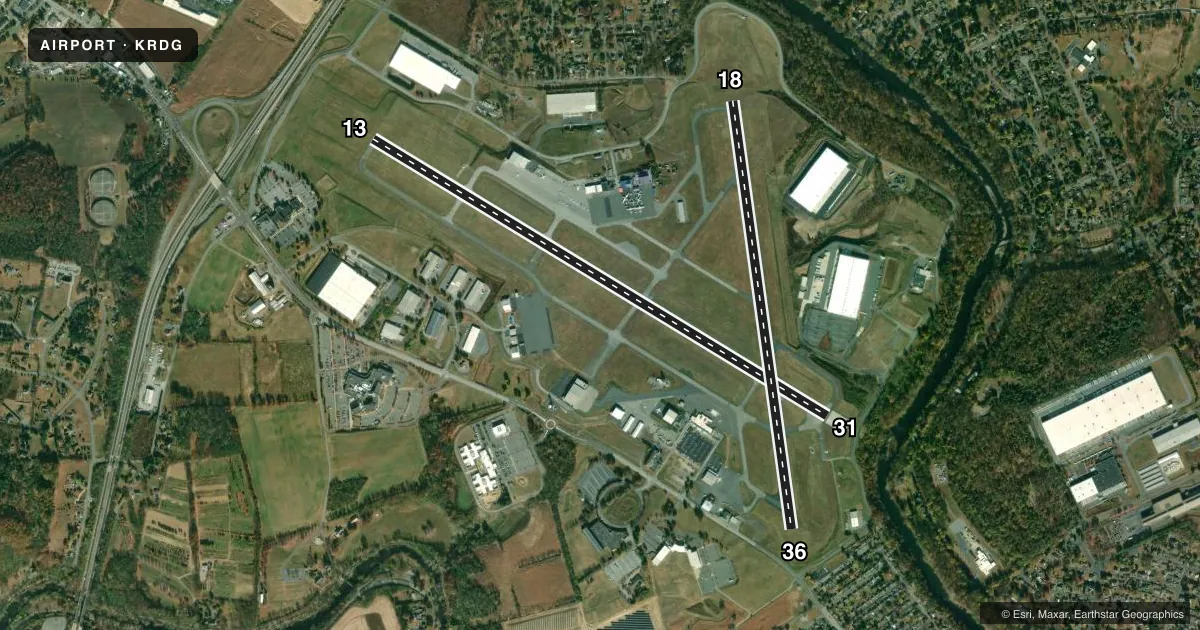
Runways & pattern
Full pagePattern entry · RWY 36
LEFT TRAFFIC| Runway | Heading (°M) | Length | Surface | Traffic |
|---|---|---|---|---|
| 13/31 | 109° / 289° | 6,350 ft | ASPH | Standard L |
| 18/36Favored | 160° / 340° | 5,151 ft | ASPH | Standard L |
Runway end performance
| End | TORA | TODA | ASDA | LDA | VGSI | Approach lights | Obstruction |
|---|---|---|---|---|---|---|---|
| 13 | 6,350' | 6,350' | 6,350' | 6,350' | PAPI 4-box left(3°) | — | 317', trees, 7661' from thr, 1213' R of cntrln, slope 23 |
| 31 | 6,350' | 6,350' | 6,350' | 6,350' | — | — | — |
| 18 | 5,151' | 5,151' | 5,151' | 5,151' | PAPI 4-box left(3°) | — | 60', trees, 893' from thr, 580' R of cntrln, slope 11 |
| 36 | 5,151' | 5,151' | 5,151' | 5,151' | — | MALSF | 19', trees, 769' from thr, 499' R of cntrln, slope 29 |
Declared distances in feet. TORA = takeoff run available, TODA = takeoff distance, ASDA = accelerate-stop, LDA = landing distance.
Airport sketch
Runways drawn to scale from FAA survey coordinates, rendered over satellite imagery. Not for navigation.
Approaches & charts
ILS · 2
Services on the field
Fuel grades, oxygen, maintenance, ramp storage and lighting — as declared to the FAA by the airport operator.
Fuel & services
- Fuel
- 100LLA
- Oxygen (bottled)
- HIGH/LOW
- Oxygen (bulk)
- HIGH/LOW
- Airframe repair
- Major
- Power plant repair
- Major
- Other services
- AFRT,AMB,AVNCS,CARGO,CHTR,INSTR,RNTL,SALES
Ramp & ground
- Transient storage
- Tie-down
- Hangar
- Landing fee
- Yes
- Customs
- Not available
- Lighting schedule
- SEE RMK
- Beacon schedule
- SS-SR
- Beacon
- White / Green (civil land)(WG)
- Wind indicator
- Lighted
- Segmented circle
- No
Fuel & FBOs
Cheapest 100LL and Jet A on the field and nearby. Always confirm with the FBO before taxi.
Airport notes
Surface conditions, obstructions, local procedures, lighting outages and other notes published with each FAA cycle.
General notes
- BIRDS ON & INVOF ARPT.
- FOR CD WHEN ATCT CLSD, CTC HARRISBURG APCH AT 800-932-0712.
- ARFF INDEX C AVBL UPON REQ CTC AMGR.
Lighting notes
- WHEN ATCT CLSD ACTVT MALSF RWY 36; REIL RWY 13, 31; PAPI RWY 13 & 18; HIRL RWY 13/31 & 18/36; TWY LGTS - CTAF.
Runway surface & condition
- 13/31PCR VALUE: 610/F/C/X/T
- 18/36PCR VALUE: 610/F/C/X/T
Approach & departure obstructions
- 13PAPI UNUSBL BYD 3 DEGS LEFT OF CNTRLN.
Arresting gear
- 13_EMASARRESTING GEAR/SYSTEM: ENGINEERED MATERIAL ARRESTING SYSTEM (EMAS) 255 FT IN LENGTH BY 170 FT IN WIDTH LOCATED AT DEP END RWY 13.
Other notes
- PPR 24 HRS FOR ACFT OPNS WITH MORE THAN 30 PAX SEATS. CALL AMGR 610-372-4666.
- LNDG FEE FOR TURBINE ACFT.
VFR map & nearby airports
VFR sectional. Tap any ICAO chip to open that airport.
Key facts · KRDG
Answer card- ICAO
- KRDG
- Name
- READING RGNL/CARL A SPAATZ FLD
- Location
- READING, PENNSYLVANIA
- Elevation
- 343.4 ft MSL
- Traffic pattern altitude
- 1,343.4 ft MSL (1,000 AGL)
- Control tower
- Towered · 0600-0000
- Total runways
- 2
- Longest runway
- 13/31 · 6,350 ft
- Published ILS approaches
- 2
- Published frequencies
- 10
- Magnetic variation
- 12°
- Current flight rules
- VFR
- Current wind
- 030° at 4 kt
- Favored runway now
- RWY 36
Reading Rgnl/Carl A Spaatz Fld is in Reading, Pennsylvania. Field elevation is 343.4 ft MSL. The airport has two asphalt runways. The longest is 6,350 ft on runway 13/31. Runway 18/36 is 5,151 ft.
The field is towered from 0600 to 0000. ILS approaches are published for runway 13 and runway 36. Pattern altitude is not published in the facts. Use the standard 1,000 ft AGL for light piston operations unless the current Chart Supplement says otherwise. Reading Aviation is on the field. It carries 100LL, Jet A and Jet A Prist.
A few operational notes matter here. Runway 13 has an EMAS at the departure end. The PAPI on runway 13 is unusable more than 3 degrees left of centerline. Birds are reported on and near the airport. When the tower is closed, lighting is activated on CTAF. That includes the MALSR for runway 36. It also includes REIL for runways 13 and 31, PAPI for runways 13 and 18 and HIRL for both runways. For clearance delivery after tower hours, contact Harrisburg Approach. Check the current FAA Chart Supplement for any noise or curfew restrictions before flying in.