METAR & TAF KRAL
Current METAR
Observed 10:53Z
KRAL 271053Z AUTO 00000KT 10SM CLR 22/16 A2993 RMK AO2 SLP118 T02220161
- Wind
- 000° @ 0 kt
- Visibility
- 10 SM
- Temp / Dew
- 22°C / 16°C
- Altimeter
- 29.93 inHg
- Clouds
- CLR
- Density alt
- 1,843 ft
- Ceiling
- Unlimited
- Rules
- VFR
Airport info & contacts
Manager on record, flight service, ARTCC, attendance schedule and pattern altitude — published by the FAA and refreshed every 28 days.
Location
- From city
- 4 NM SW
- VFR sectional
- LOS ANGELES
- ARTCC
- ZLA · LOS ANGELES
- NOTAM facility
- RAL (NOTAM-D)
Airport manager
- Name
- DR. DANIEL PRATHER
- Phone
- 951-351-6113
- Address
- 6951 FLIGHT ROAD, RIVERSIDE CA 92504
Flight service · Hours
- FSS RAL
- RIVERSIDE1-800-WX-BRIEF
- Attendance
- M-F · 0700-1700
- S-S · 0600-1600
Frequencies
Tap any row to copy the frequency to your clipboard.
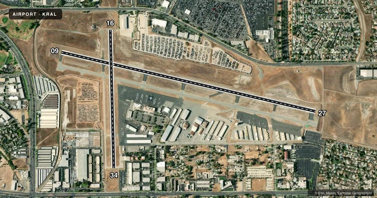
Runways & pattern
Full pagePattern entry · RWY 09
LEFT TRAFFIC| Runway | Heading (°M) | Length | Surface | Traffic |
|---|---|---|---|---|
| 09/27 | 89° / 269° | 5,401 ft | ASPH | Standard L |
| 16/34 | 165° / 345° | 2,850 ft | ASPH | 16 R |
Runway end performance
| End | TORA | TODA | ASDA | LDA | VGSI | Approach lights | Obstruction |
|---|---|---|---|---|---|---|---|
| 09 | — | — | — | — | PAPI 4-box left(3°) | — | — |
| 27 | — | — | — | — | PAPI 4-box left(3°) | — | 37', gnd, 1155' from thr, 520' R of cntrln, slope 25 |
| 34 | — | — | — | — | PAPI 2-box left(3°) | — | — |
Declared distances in feet. TORA = takeoff run available, TODA = takeoff distance, ASDA = accelerate-stop, LDA = landing distance.
Airport sketch
Runways drawn to scale from FAA survey coordinates, rendered over satellite imagery. Not for navigation.
Approaches & charts
ILS · 1
Services on the field
Fuel grades, oxygen, maintenance, ramp storage and lighting — as declared to the FAA by the airport operator.
Fuel & services
- Fuel
- 100LLA
- Oxygen (bottled)
- HIGH/LOW
- Oxygen (bulk)
- HIGH/LOW
- Airframe repair
- Major
- Power plant repair
- Major
- Other services
- CHTR,INSTR,RNTL,SALES,SURV
Ramp & ground
- Transient storage
- Tie-down
- Landing fee
- No fee published
- Customs
- Not available
- Lighting schedule
- SEE RMK
- Beacon schedule
- SS-SR
- Beacon
- White / Green (civil land)(WG)
- Wind indicator
- Lighted
- Segmented circle
- Yes
Fuel & FBOs
Cheapest 100LL and Jet A on the field and nearby. Always confirm with the FBO before taxi.
Airport notes
Surface conditions, obstructions, local procedures, lighting outages and other notes published with each FAA cycle.
General notes
- ACFT DEP RYS 09 & 27 NOT VSBL TO ACFT AT OTHER END OF RY.
- RWY 27: -20 FT DITCH 50 FT FM RWY 27 THLD.
- POWER PLANT 3,000 FT NORTH OF RY 16 THLD PRODUCING THERMAL PLUME, AVOIDANCE ADZD,
- NUMEROUS POWER LINES 1,780 - 2,887 FEET NORTH OF RY 16 THLD AT OR BLO 80 FEET AGL.
- S 1,400 FT OF RWY 34 & TWY J AND S 500 FT OF TWY B NOT VSB FM TWR.
- TWY E STEEP SLOPE
- TWY L NOT VSB FM TWR.
- FOR CD WHEN ATCT CLSD CTC SOCAL APCH AT 800-448-3724.
- TURBINE ENG ACFT: PREFERRED ROLLING TKOF FOR NOISE MGMT.
- RWY 27 DEP: FOR NOISE MGMT, AFTER DEP TURN RIGHT 10 DEGS; ASSUME CRS AFTER RCHG 1500 MSL.
- NO HIGH PWR ENG MAINT RUNS BTN 2200-0700 LCL.
- FOR NOISE MGMT: NO TURNS BFR ARPT BDRY AND 1500 MSL.
Lighting notes
- ACTVT MIRL RWYS 09/27 & 16/34; TWY LGTS; HELI PERI LGTS - CTAF. PAPI RWYS 09, 27 & 34 OPR CONSLY.
Fuel notes
- 100LLFOR FUEL AFTER HRS CALL (951) 321-0091.
Runway surface & condition
- 16/34LTD BY ARPT OPERATOR TO 12500 LBS SINGLE WHEEL GEAR.
Approach & departure obstructions
- 27SUPPLEMENTAL WIND CONE 0 FT FM THR 350 FT S OF RY CNTRLN.
Other notes
- THIS AIRPORT HAS BEEN SURVEYED BY THE NATIONAL GEODETIC SURVEY.
- TPA LGT ACFT 1000'; JET AND ALL OTHER ACFT 1500'.
- MANAGERDPRATHER@RIVERSIDECA.GOV
VFR map & nearby airports
VFR sectional. Tap any ICAO chip to open that airport.
Key facts · KRAL
Answer card- ICAO
- KRAL
- Name
- RIVERSIDE
- Location
- RIVERSIDE, CALIFORNIA
- Elevation
- 818.9 ft MSL
- Traffic pattern altitude
- 1,818.9 ft MSL (1,000 AGL)
- Control tower
- Towered · 0700-2000
- Total runways
- 2
- Longest runway
- 09/27 · 5,401 ft
- Published ILS approaches
- 1
- Published frequencies
- 10
- Magnetic variation
- 14°
- Current flight rules
- VFR
- Current wind
- 000° at 0 kt
- Favored runway now
- –
Riverside Airport sits in Riverside, California at 818.9 ft MSL. It has two asphalt runways. The longest is 09/27 at 5,401 ft. The field is towered from 0700 to 2000 local. ILS service is available for runway 09. The published pattern altitude is 1,000 ft AGL for light aircraft. Jet and other aircraft use 1,500 ft AGL.
For fuel, Raincross Aviation is on the field and carries 100LL. RAS Jetport is also on the field. It carries 100LL, Jet A and Jet A Prist. The airport sits under SoCal Class C procedures. Plan on working the tower and SoCal on 135.4 when needed. Taxiway L is not visible from the tower. The south 1,400 ft of runway 34, plus taxiway J and the south 500 ft of taxiway B, are also not visible from the tower. Runway 27 has a ditch near the threshold. Taxiway E has a steep slope. There are also power lines north of runway 16 that matter on departure. If you are new to the field, brief the runway layout carefully before taxi. Night work is supported by runway lights. PAPI is published for runways 09, 27 and 34.