METAR & TAF KPSC
Current METAR
Observed 12:53Z
KPSC 271253Z AUTO 35003KT 10SM CLR 11/09 A3001 RMK AO2 SLP160 T01110094
- Wind
- 350° @ 3 kt
- Visibility
- 10 SM
- Temp / Dew
- 11°C / 9°C
- Altimeter
- 30.01 inHg
- Clouds
- CLR
- Density alt
- -83 ft
- Ceiling
- Unlimited
- Rules
- VFR
Airport info & contacts
Manager on record, flight service, ARTCC, attendance schedule and pattern altitude — published by the FAA and refreshed every 28 days.
Location
- From city
- 2 NM NW
- VFR sectional
- SEATTLE
- ARTCC
- ZSE · SEATTLE
- NOTAM facility
- PSC (NOTAM-D)
Airport manager
- Name
- DONALD "BUCK" TAFT
- Phone
- 509-547-6352
- Address
- 3601 N 20TH AVE, PASCO WA 99301
Flight service · Hours
- FSS SEA
- SEATTLE1-800-WX-BRIEF
- Attendance
- 0800-2000
Frequencies
Tap any row to copy the frequency to your clipboard.
Runways & pattern
Full pagePattern entry · RWY 30
LEFT TRAFFIC| Runway | Heading (°M) | Length | Surface | Traffic |
|---|---|---|---|---|
| 03L/21R | 30° / 210° | 7,707 ft | ASPH | 21R R |
| 12/30Favored | 120° / 300° | 7,704 ft | ASPH | Standard L |
| 03R/21L | 30° / 210° | 4,423 ft | ASPH | 03R R |
Runway end performance
| End | TORA | TODA | ASDA | LDA | VGSI | Approach lights | Obstruction |
|---|---|---|---|---|---|---|---|
| 03L | 7,707' | 7,707' | 7,707' | 7,707' | PAPI 4-box left(3°) | — | 61', tree, 2550' from thr, 750' R of cntrln, slope 38 |
| 21R | 7,707' | 7,707' | 7,707' | 7,110' | PAPI 4-box left(3°) | MALSR | 49', pole, 1900' from thr, 450' R of cntrln, slope 34 |
| 12 | 7,704' | 7,704' | 7,704' | 7,704' | PAPI 4-box left(3°) | — | — |
| 30 | 7,704' | 7,704' | 7,704' | 7,704' | PAPI 4-box left(3°) | MALSF | 30', tree, 1312' from thr, 177' R of cntrln, slope 37 |
| 03R | 4,423' | 4,423' | 4,423' | 4,423' | — | — | — |
| 21L | 4,423' | 4,423' | 4,423' | 4,423' | — | — | 79', tower, 2445' from thr, 77' R of cntrln, slope 28 |
Declared distances in feet. TORA = takeoff run available, TODA = takeoff distance, ASDA = accelerate-stop, LDA = landing distance.
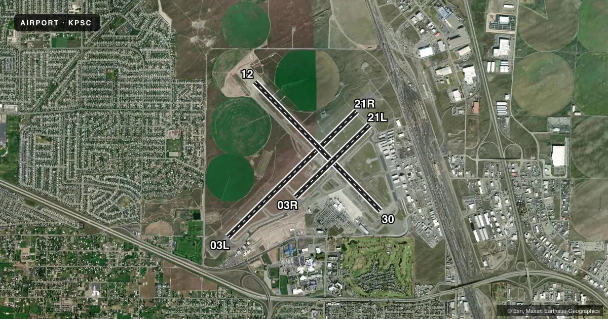
Airport sketch
Runways drawn to scale from FAA survey coordinates, rendered over satellite imagery. Not for navigation.
Approaches & charts
ILS · 1
Services on the field
Fuel grades, oxygen, maintenance, ramp storage and lighting — as declared to the FAA by the airport operator.
Fuel & services
- Fuel
- 100LLA1+
- Oxygen (bottled)
- Not available
- Oxygen (bulk)
- Low pressure
- Airframe repair
- Major
- Power plant repair
- Major
- Other services
- AFRT,AMB,AVNCS,CARGO,CHTR,INSTR,RNTL,SALES,SURV
Ramp & ground
- Transient storage
- Tie-down
- Hangar
- Landing fee
- No fee published
- Customs
- Not available
- Lighting schedule
- SEE RMK
- Beacon schedule
- SS-SR
- Beacon
- White / Green (civil land)(WG)
- Wind indicator
- Lighted
- Segmented circle
- Yes
Fuel & FBOs
Cheapest 100LL and Jet A on the field and nearby. Always confirm with the FBO before taxi.
Airport notes
Surface conditions, obstructions, local procedures, lighting outages and other notes published with each FAA cycle.
General notes
- BIRD HAZARD; SEE SPECIAL NOTICE FOR WASHINGTON IN AIM PART 3A.
- TPA 1500' TURBINE PWRD ACFT; ALL OTRS 1000'.
- WATER FOWL ON & INVOF ARPT SPRING & FALL.
- TWY G, G1 & E2 LTD TO USE BY ACFT UP TO 100000 LBS AND LESS THAN 20 FT MAIN GEAR WID.
Lighting notes
- WHEN ATCT CLSD ACTVT MALSR RWY 21R; MALSF RWY 30; REIL RWY 03L & 12; HIRL RWY 03L/21R; MIRL RWY 12/30 - CTAF. PAPI RWY 03L & 21R, 12 & 30 ON CONSLY. INCR/DECR INTST ALL RWY LGTS - CTAF.
Fuel notes
- 100LLAFT HRS FUEL CALL (509) 547-6271 WITH CALL-OUT FEE.
Runway surface & condition
- 03L/21RPCR VALUE: 384/F/B/X/U
- 12/30PCR VALUE: 466/F/B/X/T
- 03R/21LRWY 03R/21L NOT AVBL FOR PART 121/PART 380 OPS WITH SKED PAX CARRYING OPS MORE THAN 9 PAX SEATS AND NON-SKED PAX CARRYING OPS MORE THAN 30 PAX SEATS. NOT AVBL AS MOVEMENT AREA.
Approach & departure obstructions
- 21R81 FT TWR 3036 FT & 900 FT LEFT; 37:1 SLOPE TO DTHR.
Other notes
- ESTAB PRIOR TO 15 MAY 1959.
- PPR UNSKED ACR OPNS WITH MORE THAN 30 PSGR SEATS CALL AMGR 509-547-6352.
- 03R/21LRY 03R/21L SFC CRACKING.
VFR map & nearby airports
VFR sectional. Tap any ICAO chip to open that airport.
Key facts · KPSC
Answer card- ICAO
- KPSC
- Name
- TRI-CITIES
- Location
- PASCO, WASHINGTON
- Elevation
- 410.3 ft MSL
- Traffic pattern altitude
- 1,410.3 ft MSL (1,000 AGL)
- Control tower
- Towered · 0600-2200
- Total runways
- 3
- Longest runway
- 03L/21R · 7,707 ft
- Published ILS approaches
- 1
- Published frequencies
- 11
- Magnetic variation
- 15°
- Current flight rules
- VFR
- Current wind
- 350° at 3 kt
- Favored runway now
- RWY 30
Tri-Cities Airport is in Pasco, Washington. The field elevation is 410.3 ft MSL. It has three asphalt runways. The longest is runway 03L/21R at 7,707 ft. The tower is open from 0600 to 2200. When the tower is closed, lighting is activated on the common traffic advisory frequency. Runway 21R has an ILS. Pattern altitude is 1,500 ft MSL for turbine aircraft. All others use 1,000 ft MSL.
Bergstrom Aircraft is on the field. It carries 100LL, Jet A and Jet A Prist. After-hours fuel is available by calling the FBO. A call-out fee applies. The airport sits in the Tri-Cities area. Expect a busy mix of local traffic, IFR arrivals and turbine operations. The published remarks also call out bird activity in spring and fall. That matters here. Plan for wildlife awareness on taxi, takeoff and approach. Runway 21R also has a tower obstruction noted near the threshold, so brief the displaced threshold and the approach path before arrival. Taxiways G, G1 and E2 have weight and gear-width limits. Larger aircraft should check those limits before taxiing.