METAR & TAF KPKB
Current METAR
Observed 15:53Z
KPKB 271553Z VRB04KT 10SM BKN018 26/20 A2995 RMK AO2 SLP133 T02610200
- Wind
- VAR @ 4 kt
- Visibility
- 10 SM
- Temp / Dew
- 26°C / 20°C
- Altimeter
- 29.95 inHg
- Clouds
- BKN
- Density alt
- 2,347 ft
- Ceiling
- 1,800 ft AGL
- Rules
- MVFR
Airport info & contacts
Manager on record, flight service, ARTCC, attendance schedule and pattern altitude — published by the FAA and refreshed every 28 days.
Location
- From city
- 6 NM NE
- VFR sectional
- CINCINNATI
- ARTCC
- ZID · INDIANAPOLIS
- NOTAM facility
- PKB (NOTAM-D)
Airport manager
- Name
- BENJAMIN AUVILLE
- Phone
- 304-464-5113
- Address
- ROUTE 31 & AIRPORT ROAD, BOX 4089, WILLIAMSTOWN WV 26187
Flight service · Hours
- FSS EKN
- ELKINS703-724-42881-800-WX-BRIEF
- Attendance
- 0530-2230
Frequencies
Tap any row to copy the frequency to your clipboard.
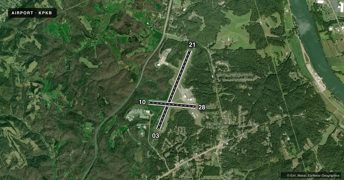
Runways & pattern
Full pagePattern entry · RWY 03
LEFT TRAFFIC| Runway | Heading (°M) | Length | Surface | Traffic |
|---|---|---|---|---|
| 03/21Favored | 14° / 194° | 7,240 ft | ASPH | Standard L |
| 10/28 | 87° / 267° | 4,002 ft | ASPH | Standard L |
Runway end performance
| End | TORA | TODA | ASDA | LDA | VGSI | Approach lights | Obstruction |
|---|---|---|---|---|---|---|---|
| 03 | 7,240' | 7,240' | 6,780' | 6,780' | PAPI 4-box left(3°) | MALSR | — |
| 21 | 7,240' | 7,240' | 7,240' | 6,780' | PAPI 4-box right(3°) | — | — |
| 10 | 4,002' | 4,002' | 4,002' | 4,002' | PAPI 2-box left(3°) | — | — |
| 28 | 4,002' | 4,002' | 4,002' | 4,002' | PAPI 2-box left(3°) | — | — |
Declared distances in feet. TORA = takeoff run available, TODA = takeoff distance, ASDA = accelerate-stop, LDA = landing distance.
Airport sketch
Runways drawn to scale from FAA survey coordinates, rendered over satellite imagery. Not for navigation.
Approaches & charts
ILS · 1
Services on the field
Fuel grades, oxygen, maintenance, ramp storage and lighting — as declared to the FAA by the airport operator.
Fuel & services
- Fuel
- 100LLA
- Oxygen (bottled)
- Not available
- Oxygen (bulk)
- Not available
- Airframe repair
- Minor
- Power plant repair
- Minor
- Other services
- CHTR,INSTR,RNTL,SALES
Ramp & ground
- Transient storage
- Tie-down
- Hangar
- Landing fee
- Yes
- Customs
- Not available
- Lighting schedule
- SEE RMK
- Beacon schedule
- SS-SR
- Beacon
- White / Green (civil land)(WG)
- Wind indicator
- Lighted
- Segmented circle
- No
Fuel & FBOs
Cheapest 100LL and Jet A on the field and nearby. Always confirm with the FBO before taxi.
Airport notes
Surface conditions, obstructions, local procedures, lighting outages and other notes published with each FAA cycle.
General notes
- BIRDS & DEER ON & INVOF ARPT.
- NO LANDING FEE FOR ACFT LESS THAN 6500 LBS; FOR ACFT GREATER THAN 6500, LNDG FEE WAIVED WITH FUEL PURCHASES.
- ARNG OPS DSN 661-3400 C304-464-4530.
- WHEN ATCT CLSD, FOR CD CTC INDIANAPOLIS ARTCC AT 317-247-2411.
Lighting notes
- WHEN ATCT CLSD ACTVT MALSR RWY 03; REIL RWY 10 & 21; HIRL RWY 03/21 & 10/28 - CTAF. PAPI RWY 03 & 21 OPR CONSLY. REIL RWY 28 UNAVBL WHEN ATCT CLSD.
Runway surface & condition
- 03/21PCR VALUE: 390/F/D/X/T
- 10/28PCR VALUE: 380/R/D/W/T
Approach & departure obstructions
- 21UNUSBL BYD 5 DEGS LEFT AND 9 DEGS RIGHT OF CNTRLN.
- 28UNUSBL BYD 8 DEGS LEFT AND 8 DEGS RIGHT OF CNTRLN.
Other notes
- PPR 30 MIN FOR UNSCHEDULED ACR OPNS WITH MORE THAN 30 PSGR SEATS; CALL AMGR (304) 464-5115.
- OWNERFEDEX DELIVERY: 543 AIRPORT RD, WILLIAMSTOWN, WV 26187
VFR map & nearby airports
VFR sectional. Tap any ICAO chip to open that airport.
Key facts · KPKB
Answer card- ICAO
- KPKB
- Name
- MID-OHIO VALLEY RGNL
- Location
- PARKERSBURG, WEST VIRGINIA
- Elevation
- 858.5 ft MSL
- Traffic pattern altitude
- 1,858.5 ft MSL (1,000 AGL)
- Control tower
- Towered · 0700-2300
- Total runways
- 2
- Longest runway
- 03/21 · 7,240 ft
- Published ILS approaches
- 1
- Published frequencies
- 8
- Magnetic variation
- 8°
- Current flight rules
- MVFR
- Current wind
- 000° at 4 kt
- Favored runway now
- RWY 03
Mid-Ohio Valley Rgnl Airport sits in Parkersburg, West Virginia. Field elevation is 858.5 ft MSL. The airport has two asphalt runways. The longest is 7,240 ft runway 03/21. Tower service is published from 0700 to 2300. One ILS approach is available to runway 03. Pattern altitude is not published, so verify the current traffic pattern in the FAA Chart Supplement before you go. The field is in a busy local operating environment. Birds and deer are reported on and near the airport. Keep a sharp scan on departure and arrival.
Mid-Ohio Valley Regional Airport is the on-field FBO. It carries 100LL, Jet A and Jet A Prist. If you need handling or current ramp details, call the field directly at (304) 464-5115. Published remarks also note that some operations need prior permission 30 minutes ahead when the aircraft has more than 30 passenger seats. When the tower is closed, clearance delivery goes through Indianapolis ARTCC. Lighting procedures also change after tower hours, so verify the current Chart Supplement before a night arrival. Runway 03/21 has published PCN data. That matters if you are bringing in heavier equipment.