METAR & TAF KPIE
Current METAR
Observed 18:53Z
KPIE 271853Z 21011KT 10SM SCT039 BKN120 26/24 A2994 RMK AO2 SLP138 T02610244
- Wind
- 210° @ 11 kt
- Visibility
- 10 SM
- Temp / Dew
- 26°C / 24°C
- Altimeter
- 29.94 inHg
- Clouds
- BKN
- Density alt
- 1,308 ft
- Ceiling
- 12,000 ft AGL
- Rules
- VFR
Airport info & contacts
Manager on record, flight service, ARTCC, attendance schedule and pattern altitude — published by the FAA and refreshed every 28 days.
Location
- From city
- 8 NM N
- VFR sectional
- MIAMI
- ARTCC
- ZMA · MIAMI
- NOTAM facility
- PIE (NOTAM-D)
Airport manager
- Name
- MARK SPRAGUE
- Phone
- 727-453-7800
- Address
- ST PETE-CLEARWATER INTERNATIONAL, CLEARWATER FL 33762
Flight service · Hours
- FSS PIE
- SAINT PETERSBURG1-800-WX-BRIEF
- Attendance
- ALL
Frequencies
Tap any row to copy the frequency to your clipboard.
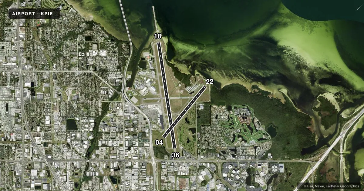
Runways & pattern
Full pagePattern entry · RWY 22
LEFT TRAFFIC| Runway | Heading (°M) | Length | Surface | Traffic |
|---|---|---|---|---|
| 18/36 | 166° / 346° | 9,730 ft | ASPH | Standard L |
| 04/22Favored | 35° / 215° | 6,000 ft | ASPH | Standard L |
Runway end performance
| End | TORA | TODA | ASDA | LDA | VGSI | Approach lights | Obstruction |
|---|---|---|---|---|---|---|---|
| 18 | 9,730' | 9,730' | 9,180' | 9,180' | PAPI 4-box left(3°) | MALSR | 9', brush, 665' from thr, 280' R of cntrln, slope 50 |
| 36 | 9,730' | 9,730' | 9,650' | 8,720' | PAPI 4-box left(3°) | — | 30', tree, 450' from thr, 425' R of cntrln, slope 8 |
| 04 | 6,000' | 6,000' | 6,000' | 6,000' | PAPI 4-box left(3°) | — | 32', trees, 1135' from thr, 10' R of cntrln, slope 29 |
| 22 | 6,000' | 6,000' | 6,000' | 6,000' | PAPI 4-box left(3°) | — | 8', road, 270' from thr, 250' R of cntrln, slope 8 |
Declared distances in feet. TORA = takeoff run available, TODA = takeoff distance, ASDA = accelerate-stop, LDA = landing distance.
Airport sketch
Runways drawn to scale from FAA survey coordinates, rendered over satellite imagery. Not for navigation.
Approaches & charts
ILS · 2
Services on the field
Fuel grades, oxygen, maintenance, ramp storage and lighting — as declared to the FAA by the airport operator.
Fuel & services
- Fuel
- 100AA1+
- Oxygen (bottled)
- Not available
- Oxygen (bulk)
- HIGH/LOW
- Airframe repair
- Major
- Power plant repair
- Major
- Other services
- AFRT,AMB,CHTR,INSTR,RNTL
Ramp & ground
- Transient storage
- Tie-down
- Hangar
- Landing fee
- No fee published
- Customs
- Not available
- Lighting schedule
- SEE RMK
- Beacon schedule
- SS-SR
- Beacon
- White / Green (civil land)(WG)
- Wind indicator
- Lighted
- Segmented circle
- No
Fuel & FBOs
Cheapest 100LL and Jet A on the field and nearby. Always confirm with the FBO before taxi.
Airport notes
Surface conditions, obstructions, local procedures, lighting outages and other notes published with each FAA cycle.
General notes
- NOISE SENSITIVE AREA 5 MI N EXTDG 1 MI E & W OF LOC SB TO SHORELINE.
- MILITARY: CONTRACT AVOIL O-128 AVBL.
- TBJT LNDG RWY 18 & DEP RWY 36 USE PUBLD NOISE ABATEMENT PROC.
- LGTS ON HWY N OF ARPT MAY BE MISTAKEN FOR RWY LGTS.
- BANNER TOWING NA.
- BIRDS ON & INVOF ARPT.
- FOR CD IF UNA TO CTC ON FSS FREQ, CTC TAMPA APCH AT 813-878-2528.
- PPR RQRD FOR ALL TRANS ACFT REQUESTING TO PRK ON CLEARWATER USAR MIL RAMP/APRON. MUST CTC CLEARWATER ARMY SUPPORT FAC OPS AT (910)-771-3046 OR ASF MACDILL AT (813)-828-3183/3180 UP TO 7 DAYS BFR ARR. MIN NOTICE IS 24 HOURS BFR ARR. 1000Z-0300Z M-TH OR FRI 1000Z-1830Z EXCLUDING HOLIDAYS & WEEKENDS.
Lighting notes
- WHEN ATCT CLSD ACTVT MALSR RWY 18; TDZ RWY 18; CNTLN RWY 18/36; MIRL RWY 04/22; HIRL RWY 18/36; TWY LGTS - CTAF.
Runway surface & condition
- 04/22PCR VALUE: 360/F/B/X/T
- 18/36PCR VALUE: 490/F/A/X/T
Approach & departure obstructions
- 366 FT FENCE 200 FT BFR AER 483 FT R OF CNTRLN.
- 22APCH RATIO 34:1 TO THR.
- 36APCH RATIO 50:1 TO DTHR.
VFR map & nearby airports
VFR sectional. Tap any ICAO chip to open that airport.
Key facts · KPIE
Answer card- ICAO
- KPIE
- Name
- ST PETE-CLEARWATER INTL
- Location
- ST PETERSBURG-CLEARWATER, FLORIDA
- Elevation
- 10.7 ft MSL
- Traffic pattern altitude
- 1,010.7 ft MSL (1,000 AGL)
- Control tower
- Towered · 0600-2300
- Total runways
- 2
- Longest runway
- 18/36 · 9,730 ft
- Published ILS approaches
- 2
- Published frequencies
- 12
- Magnetic variation
- 5°
- Current flight rules
- VFR
- Current wind
- 210° at 11 kt
- Favored runway now
- RWY 22
ST PETE-CLEARWATER INTL sits in St Petersburg-Clearwater, Florida. Field elevation is 10.7 ft MSL. The airport has two asphalt runways. Runway 18/36 is the longest at 9,730 ft. Runway 04/22 is 6,000 ft. The tower is open 0600-2300. Two ILS approaches are published for runway ends 18 and 36.
For pattern work, the published pattern altitude is not listed. Use 1,000 ft AGL for light piston operations unless the current Chart Supplement says otherwise. That puts you at about 1,011 ft MSL here. The airport is busy enough to pay attention to taxi and runway assignment, especially with the long north-south runway and the shorter crosswind runway.
Signature Aviation is on the field. It carries 100LL and Jet A. Sheltair is also on the field. It carries 100LL, Jet A and Jet A Prist. The airport has published noise-sensitive areas north of the field. There is also a published noise abatement requirement for touch-and-go landings on runway 18 and departures from runway 36. Birds are reported on and near the airport. Lights on the highway north of the airport may be mistaken for runway lights, so brief that on arrival. Check the current Chart Supplement for any current noise or curfew restrictions before flying in.