METAR & TAF KPDK
Current METAR
Observed 13:12Z
KPDK 271312Z 25006KT 6SM BR BKN008 BKN022 26/24 A2995 RMK AO2 LTG DSNT SW T02610239
- Wind
- 250° @ 6 kt
- Visibility
- 6 SM
- Temp / Dew
- 26°C / 24°C
- Altimeter
- 29.95 inHg
- Clouds
- BKN
- Density alt
- 2,521 ft
- Ceiling
- 800 ft AGL
- Rules
- IFR
Airport info & contacts
Manager on record, flight service, ARTCC, attendance schedule and pattern altitude — published by the FAA and refreshed every 28 days.
Location
- From city
- 8 NM NE
- VFR sectional
- ATLANTA
- ARTCC
- ZTL · ATLANTA
- NOTAM facility
- PDK (NOTAM-D)
Airport manager
- Name
- HUNTER HINES
- Phone
- 770-936-5440
- Address
- 2000 AIRPORT RD / RM 212, ATLANTA GA 30341
Flight service · Hours
- FSS MCN
- MACON1-800-WX-BRIEF
- Attendance
- ALL
Frequencies
Tap any row to copy the frequency to your clipboard.
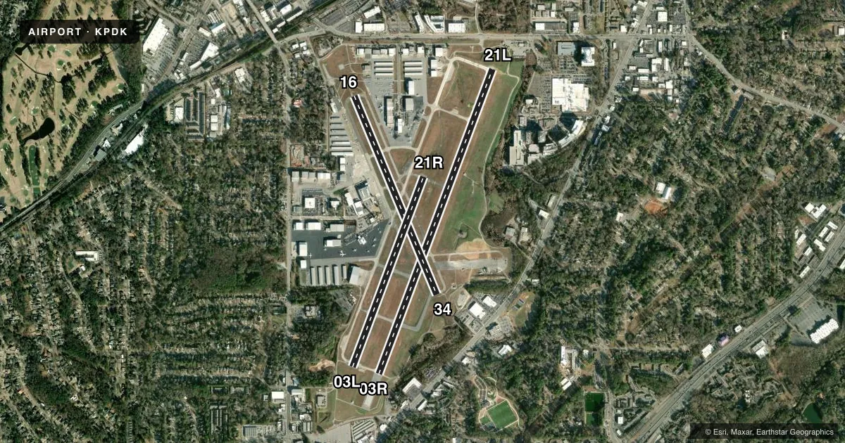
Runways & pattern
Full pagePattern entry · RWY 21L
LEFT TRAFFIC| Runway | Heading (°M) | Length | Surface | Traffic |
|---|---|---|---|---|
| 03R/21LFavored | 16° / 196° | 6,001 ft | CONC | 03R R |
| 16/34 | 152° / 332° | 3,968 ft | ASPH | Standard L |
| 03L/21R | 16° / 196° | 3,746 ft | ASPH | 21R R |
Runway end performance
| End | TORA | TODA | ASDA | LDA | VGSI | Approach lights | Obstruction |
|---|---|---|---|---|---|---|---|
| 03R | 5,411' | 6,001' | 5,411' | 5,411' | VASI 4-box left(3°) | — | 1', bldg, 201' from thr, 452' R of cntrln, slope 1 |
| 21L | 6,001' | 6,001' | 6,001' | 5,001' | PAPI 2-box right(3°) | MALSF | 40', pole, 556' from thr, 338' R of cntrln, slope 8 |
| 16 | — | — | — | — | VASI 4-box left(3.4°) | — | 86', trees, 1703' from thr, 95' R of cntrln, slope 17 |
| 34 | — | — | — | — | VASI 4-box left(3.3°) | — | 41', trees, 366' from thr, 97' R of cntrln, slope 4 |
| 03L | — | — | — | — | PAPI 2-box left(3°) | — | 49', trees, 1310' from thr, 65' R of cntrln, slope 22 |
| 21R | — | — | — | — | PAPI 2-box left(3°) | — | — |
Declared distances in feet. TORA = takeoff run available, TODA = takeoff distance, ASDA = accelerate-stop, LDA = landing distance.
Airport sketch
Runways drawn to scale from FAA survey coordinates, rendered over satellite imagery. Not for navigation.
Approaches & charts
ILS · 1
Services on the field
Fuel grades, oxygen, maintenance, ramp storage and lighting — as declared to the FAA by the airport operator.
Fuel & services
- Fuel
- 100LLAA+
- Oxygen (bottled)
- HIGH/LOW
- Oxygen (bulk)
- HIGH/LOW
- Airframe repair
- Major
- Power plant repair
- Major
- Other services
- AMB,AVNCS,CHTR,INSTR,RNTL,SALES
Ramp & ground
- Transient storage
- Tie-down
- Hangar
- Landing fee
- Yes
- Customs
- Not available
- Lighting schedule
- SEE RMK
- Beacon schedule
- SS-SR
- Beacon
- White / Green (civil land)(WG)
- Wind indicator
- Lighted
- Segmented circle
- No
Fuel & FBOs
Cheapest 100LL and Jet A on the field and nearby. Always confirm with the FBO before taxi.
Airport notes
Surface conditions, obstructions, local procedures, lighting outages and other notes published with each FAA cycle.
General notes
- VOLUNTARY NIGHT CURFEW IN EFFECT FROM 2300-0600. NO HIGH POWER ENGINE/MAINTENANCE RUNUPS FROM 2200-0700.
- NOISE SENSITIVE AREAS ALL QUADRANTS. PILOTS USE CLOSE-IN DEPARTURE PROCEDURES.
- HEAVY VFR HELO OPS NW CORNER AND EASTSIDE OF ARPT. HELI LCTD NORTH OF RY 16 THLD.
- PPR FOR ALL TRANSIENT MIL ACFT.
- PPR FOR ACFT WITH MAX GROSS CERTIF WEIGHT MORE THAN 75,000 LBS.
- BE ALERT DURG ACFT GRND OPS. MULTIPLE RY/TWY CROSSINGS REQUIRED.
- BE ALERT: PILOTS SHOULD BE ALERT WHEN OPERATING AT PDK DUE TO HIGH NUMBER OF RY INCURSIONS.
- ALL TWY K AND ALL TWY L AND TWY C EAST OF TWY D ARE NON-MOVEMENT AREAS.
Lighting notes
- PERIMETER LGTS H1 OPER DUSK-DAWN. REIL RWY 03R; VASI RWY 03R, 16, 34; PAPI RWY 03L, 21L, 21R; MIRL RWY 03L/21R, 16/34 - OPR DRG TWR HRS. WHEN ATCT CLSD HIRL RWY 03R/21L PRESET MED INTST; TO INCR INTST & ACTVT MALSF RWY 21L AND TWY LGTS - 120.0.
Approach & departure obstructions
- 03R3R/21L MARKINGS FADED
- 21L3R/21L MARKINGS FADED
- 21LRWY 21L APCH RATIO 32:1 TO DSPLCD THLD.
Arresting gear
- 21L_EMASENGINEERED MATERIALS ARRESTING SYSTEM, 160 FT IN WIDE 600 FT IN LENGTH, LOCATED AT DEPARTURE END OF RWY 21L.
Other notes
- EXISTED PRIOR TO 1959.
- ARFF ON FIELD, NO INDEX.
- SEE AIRPORT WEBSITE (PDKAIRPORT.ORG) FOR FEES AND EXEMPTIONS
VFR map & nearby airports
VFR sectional. Tap any ICAO chip to open that airport.
Key facts · KPDK
Answer card- ICAO
- KPDK
- Name
- DEKALB-PEACHTREE
- Location
- ATLANTA, GEORGIA
- Elevation
- 998.4 ft MSL
- Traffic pattern altitude
- 1,998.4 ft MSL (1,000 AGL)
- Control tower
- Towered · 0630-2300 MON-FRI 0700-2300 SAT & SUN
- Total runways
- 3
- Longest runway
- 03R/21L · 6,001 ft
- Published ILS approaches
- 1
- Published frequencies
- 11
- Magnetic variation
- 5°
- Current flight rules
- IFR
- Current wind
- 250° at 6 kt
- Favored runway now
- RWY 21L
DeKalb-Peachtree Airport is in Atlanta, Georgia. Field elevation is 998.4 ft MSL. It has 3 runways. The longest is 6,001 ft on 03R/21L. The airport is towered. Tower hours are 0630-2300 Monday through Friday. Weekend hours are 0700-2300 Saturday and Sunday. One ILS is published for runway 21L. Pattern altitude is not published. Use 1,000 ft AGL for light piston traffic unless ATC or the current Chart Supplement says otherwise.
This is a busy metro airport with a lot of runway and taxiway crossings. Noise sensitive areas exist in all quadrants. Use close-in departure procedures. A voluntary night curfew runs from 2300 to 0600. No high power engine or maintenance runups are allowed from 2200 to 0700. The airport also has several lighting notes that matter at night. Runway 21L has MALSR lighting. Runway 03R has runway end identifier lights. PAPI is on 03L, 21L and 21R. VASI is on 03R, 16 and 34.
On the field, Atlantic Aviation carries 100LL and Jet A. Signature Aviation carries 100LL, Jet A and Jet A Prist. Aero Center carries 100LL, Jet A and Jet A Prist. Heavy aircraft over 75,000 pounds need prior permission. Transient military aircraft also need prior permission. Watch the ground closely. The published remarks call out a high number of runway incursions here.