METAR & TAF KOSH
Current METAR
Observed 15:15Z
KOSH 271515Z AUTO 18012KT 1 3/4SM R36/3000VP6000FT +TSRA BR BKN014 BKN028 BKN040 28/26 A2968 RMK AO2 LTG DSNT S AND SW RAB11 TSB05 P0011 T02780256
- Wind
- 180° @ 12 kt
- Visibility
- 0.75 SM
- Temp / Dew
- 28°C / 26°C
- Altimeter
- 29.68 inHg
- Clouds
- BKN
- Density alt
- 2,860 ft
- Ceiling
- 1,400 ft AGL
- Rules
- LIFR
Airport info & contacts
Manager on record, flight service, ARTCC, attendance schedule and pattern altitude — published by the FAA and refreshed every 28 days.
Location
- From city
- 2 NM S
- VFR sectional
- CHICAGO
- ARTCC
- ZAU · CHICAGO
- NOTAM facility
- OSH (NOTAM-D)
Airport manager
- Name
- JAMES SCHELL
- Phone
- 920-236-4930
- Address
- 525 W 20TH AVE, OSHKOSH WI 54902
Flight service · Hours
- FSS GRB
- GREEN BAY1-800-WX-BRIEF
- Attendance
- MON-FRI · 0700-1900
- SAT-SUN · 0800-1700
Frequencies
Tap any row to copy the frequency to your clipboard.
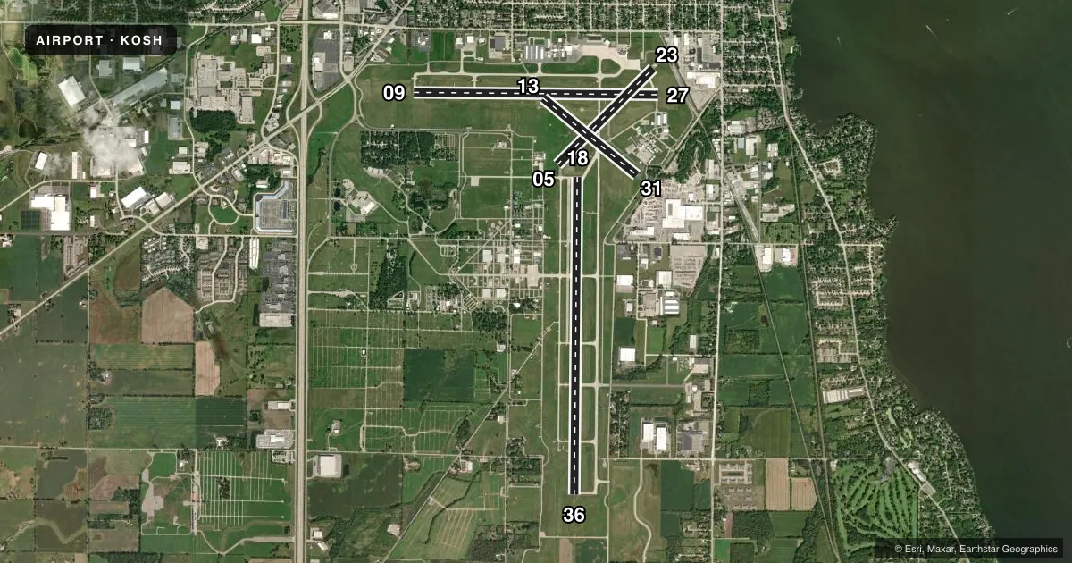
Runways & pattern
Full pagePattern entry · RWY 18
LEFT TRAFFIC| Runway | Heading (°M) | Length | Surface | Traffic |
|---|---|---|---|---|
| 18/36Favored | 178° / 358° | 8,002 ft | CONC | Standard L |
| 09/27 | 88° / 268° | 6,179 ft | CONC | Standard L |
| 05/23 | 42° / 222° | 3,424 ft | ASPH | Standard L |
| 13/31 | 126° / 306° | 3,061 ft | ASPH | Standard L |
Runway end performance
| End | TORA | TODA | ASDA | LDA | VGSI | Approach lights | Obstruction |
|---|---|---|---|---|---|---|---|
| 18 | — | — | — | — | PAPI 4-box left(3°) | — | 15', ant, 550' from thr, 250' R of cntrln, slope 23 |
| 36 | — | — | — | — | PAPI 4-box left(3°) | MALSR | 61', trees, 3000' from thr, 185' R of cntrln, slope 45 |
| 09 | 6,179' | 6,179' | 5,648' | 5,648' | PAPI 4-box left(3°) | — | — |
| 27 | 6,179' | 6,179' | 6,179' | 5,648' | PAPI 4-box left(3°) | — | 37', tree, 720' from thr, 150' R of cntrln, slope 14 |
| 23 | — | — | — | — | — | — | 21', rr, 500' from thr, 155' R of cntrln, slope 14 |
| 31 | — | — | — | — | — | — | 15', road, 217' from thr, 127' R of cntrln, slope 1 |
Declared distances in feet. TORA = takeoff run available, TODA = takeoff distance, ASDA = accelerate-stop, LDA = landing distance.
Airport sketch
Runways drawn to scale from FAA survey coordinates, rendered over satellite imagery. Not for navigation.
Approaches & charts
ILS · 1
Services on the field
Fuel grades, oxygen, maintenance, ramp storage and lighting — as declared to the FAA by the airport operator.
Fuel & services
- Fuel
- 100LLA+
- Oxygen (bottled)
- Not available
- Oxygen (bulk)
- HIGH/LOW
- Airframe repair
- Major
- Power plant repair
- Major
- Other services
- AFRT,AVNCS,CARGO,CHTR,INSTR,RNTL,SALES
Ramp & ground
- Transient storage
- Tie-down
- Hangar
- Landing fee
- No fee published
- Customs
- Not available
- Lighting schedule
- SEE RMK
- Beacon schedule
- SS-SR
- Beacon
- White / Green (civil land)(WG)
- Wind indicator
- Lighted
- Segmented circle
- No
Fuel & FBOs
Cheapest 100LL and Jet A on the field and nearby. Always confirm with the FBO before taxi.
Airport notes
Surface conditions, obstructions, local procedures, lighting outages and other notes published with each FAA cycle.
General notes
- BIRDS ON & INVOF ARPT.
- RWYS 13/31, 05/23 & TWYS C, H, P NOT AVBL TO ACFT WITH MORE THAN 30 PSGR SEATS.
- RY 23 & RY 27 APCH ENDS ARE CLOSELY ALIGNED. VERIFY CORRECT RY AND COMPASS HEADING PRIOR TO DEP.
- FOR CD IF UNA TO CTC ON FSS FREQ, CTC CHICAGO ARTCC AT 630-906-8921.
- SFC CONDS NOT MONTRD BTWN 2200 - 0500 HRS.
Lighting notes
- WHEN ATCT CLSD, ACTVT MALSR RWY 36; REIL RWY 18 & 27; HIRL RWY 09/27 & 18/36 - CTAF. HIRL 18/36 PRESET ON LOW INTST SS-SR, TO INCR INTST & ACTVT - CTAF. PAPI RWY 09, 27, 18 & 36 OPR CONSLY.
Fuel notes
- A+A+ AND 100LL AVBL FOR FEE AFTER HRS, 920-236-7827.
Runway surface & condition
- 05/23MAXIMUM WEIGHT BEARING CAPACITY FOR ANY ACFT IS 50000 LBS.
- 13/31MAXIMUM WEIGHT BEARING CAPACITY FOR ANY ACFT IS 50000 LBS.
Approach & departure obstructions
- 27APCH RATIO 34:1 TO DTHR.
Other notes
- MANAGERJSCHELL@WINNEBAGOCOUNTYWI.GOV.
VFR map & nearby airports
VFR sectional. Tap any ICAO chip to open that airport.
Key facts · KOSH
Answer card- ICAO
- KOSH
- Name
- WITTMAN RGNL
- Location
- OSHKOSH, WISCONSIN
- Elevation
- 808.5 ft MSL
- Traffic pattern altitude
- 1,808.5 ft MSL (1,000 AGL)
- Control tower
- Towered · 16 MAR-31 OCT 0600-2200, 1 NOV-15 MAR 0600-2100
- Total runways
- 4
- Longest runway
- 18/36 · 8,002 ft
- Published ILS approaches
- 1
- Published frequencies
- 10
- Magnetic variation
- 3°
- Current flight rules
- LIFR
- Current wind
- 180° at 12 kt
- Favored runway now
- RWY 18
Wittman Rgnl sits in Oshkosh, Wisconsin. Field elevation is 808.5 ft MSL. The airport has four runways. The longest is runway 18/36 at 8,002 ft. The field is towered. Tower hours are 0600-2200 from 16 Mar to 31 Oct. Hours are 0600-2100 from 1 Nov to 15 Mar. There is one ILS approach. It serves runway 36. Pattern altitude is not published. Use 1,000 ft AGL for light piston traffic unless ATC gives you something different.
Basler Flight Service is on the field. It carries 100LL and Jet A. Birds are present on and near the airport. Runways 13/31 and 05/23 have published 50,000 pound maximum weight bearing limits. Runways 13/31, 05/23, plus taxiways C, H and P are not available to aircraft with more than 30 passenger seats. Runways 23 and 27 are closely aligned at the approach ends. Verify the runway and heading before departure. The airport also has published lighting procedures for when the tower is closed. Check the current FAA Chart Supplement before you go if you need the exact activation steps or any current surface condition details. Surface conditions are not monitored between 2200 and 0500.