METAR & TAF KNYL
Current METAR
Observed 11:57Z
KNYL 271157Z AUTO 17004KT 10SM CLR 32/18 A2979 RMK AO2 SLP085 T03170178 10344 20317 53001
- Wind
- 170° @ 4 kt
- Visibility
- 10 SM
- Temp / Dew
- 32°C / 18°C
- Altimeter
- 29.79 inHg
- Clouds
- CLR
- Density alt
- 2,466 ft
- Ceiling
- Unlimited
- Rules
- VFR
Airport info & contacts
Manager on record, flight service, ARTCC, attendance schedule and pattern altitude — published by the FAA and refreshed every 28 days.
Location
- From city
- 3 NM S
- VFR sectional
- PHOENIX
- ARTCC
- ZLA · LOS ANGELES
- NOTAM facility
- NYL (NOTAM-D)
Airport manager
- Name
- GREGORY MCSHANE
- Phone
- 928-269-3327
- Address
- 2356 E O'NEILL ST, BLDG 153, YUMA AZ 85369-9114
Flight service · Hours
- FSS PRC
- PRESCOTT1-800-WX-BRIEF
- Attendance
- Continuous
Frequencies
Tap any row to copy the frequency to your clipboard.
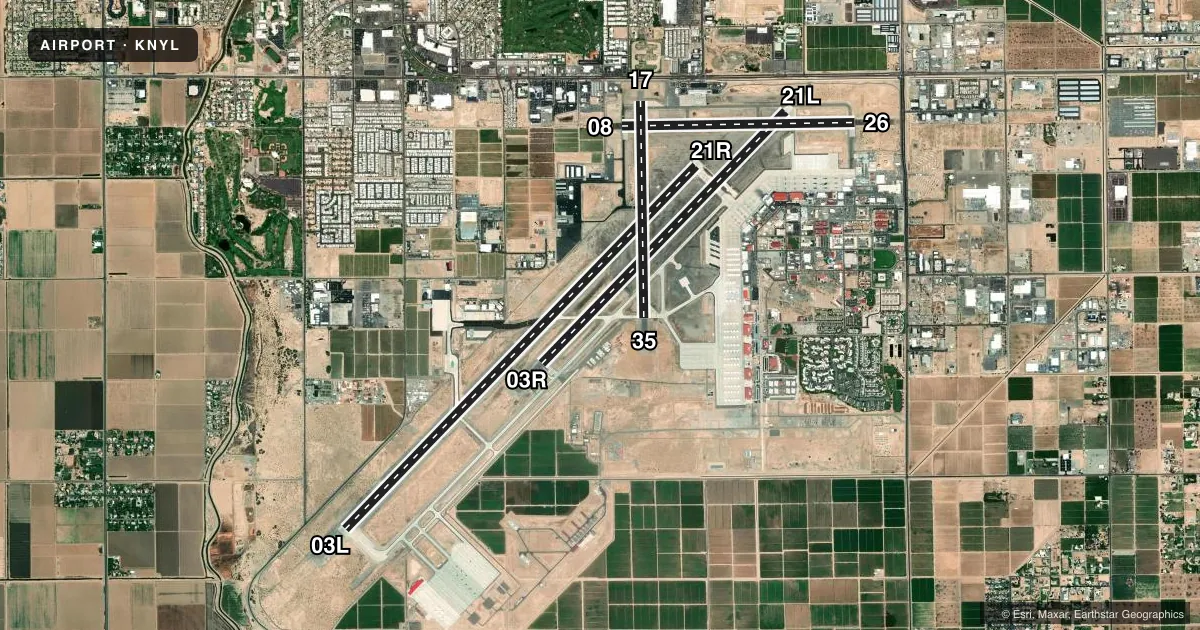
Runways & pattern
Full pagePattern entry · RWY 17
RIGHT TRAFFIC| Runway | Heading (°M) | Length | Surface | Traffic |
|---|---|---|---|---|
| 03L/21R | 31° / 211° | 13,300 ft | CONC | 03L R |
| 03R/21L | 31° / 211° | 9,240 ft | ASPH-CONC | 03R R |
| 08/26 | 76° / 256° | 6,146 ft | ASPH | 08 R |
| 17/35Favored | 166° / 346° | 5,710 ft | ASPH-CONC | 17 R |
Runway end performance
| End | TORA | TODA | ASDA | LDA | VGSI | Approach lights | Obstruction |
|---|---|---|---|---|---|---|---|
| 03L | 13,300' | 13,300' | 13,300' | 13,300' | PAPI 4-box left(3°) | — | — |
| 21R | 13,300' | 13,300' | 13,300' | 13,300' | PAPI 4-box left(3°) | MALSR | — |
| 03R | 9,240' | 9,240' | 9,240' | 9,240' | PAPI 4-box left(3°) | — | 29', ant, 650' from thr, 300' R of cntrln, slope 15 |
| 21L | 9,240' | 9,240' | 9,240' | 9,240' | PAPI 4-box left(3°) | — | 18', road, 1250' from thr, slope 50 |
| 08 | 6,146' | 6,146' | 6,146' | 6,146' | — | — | 15', road, 490' from thr, slope 19 |
| 26 | 6,146' | 6,146' | 6,146' | 6,146' | — | — | 14', road, 1250' from thr, slope 50 |
| 17 | 5,710' | 5,710' | 5,710' | 5,710' | PAPI 4-box left(3°) | — | 72', tree, 1980' from thr, 150' R of cntrln, slope 24 |
| 35 | 5,710' | 5,710' | 5,710' | 5,710' | — | — | 4', brush, 300' from thr, 120' R of cntrln, slope 25 |
Declared distances in feet. TORA = takeoff run available, TODA = takeoff distance, ASDA = accelerate-stop, LDA = landing distance.
Airport sketch
Runways drawn to scale from FAA survey coordinates, rendered over satellite imagery. Not for navigation.
Approaches & charts
ILS · 1
Services on the field
Fuel grades, oxygen, maintenance, ramp storage and lighting — as declared to the FAA by the airport operator.
Fuel & services
- Fuel
- 100AA+
- Oxygen (bottled)
- HIGH/LOW
- Oxygen (bulk)
- HIGH/LOW
- Airframe repair
- Minor
- Power plant repair
- Minor
- Other services
- AFRT,AMB,AVNCS,CHTR,INSTR,RNTL
Ramp & ground
- Transient storage
- Tie-down
- Landing fee
- No fee published
- Customs
- Available
- Lighting schedule
- SEE RMK
- Beacon schedule
- SS-SR
- Beacon
- White / Green (civil land)(WG)
- Wind indicator
- Lighted
- Segmented circle
- No
Fuel & FBOs
Cheapest 100LL and Jet A on the field and nearby. Always confirm with the FBO before taxi.
Airport notes
Surface conditions, obstructions, local procedures, lighting outages and other notes published with each FAA cycle.
General notes
- CTN: TFC PAT RWY 03L/R & 21L/R OVERLAP TFC PAT RWY 08/26 & 17/35.
- 976 FT STWY RWY 03R; 1000 FT STWY RWY 21L; 1000 FT STWY RWY 03L; 1000 FT STWY RWY 21R; 1000 FT STWY RWY 08; 251 FT STWY RWY 26; 800 FT STWY RWY 17; 262 FT STWY RWY 35.
- GEN AVN & ACR VFR DEP FLY RWY HDG MNTN 1200 FT UNTIL OUTSIDE ATA UNLESS OTRW APVD BY TWR.
- MIL JET OPS FM 4000-3000 FT MSL DESCENDING TO 1700 FT MSL WI 6 NM SW STRAIGHT-IN RWY 03L & 03R & WI 6 NM NE STRAIGHT-IN RWY 21R & 21L.
- CTN: JOINT USE CIVIL/MIL ARPT; GEN AVN & ACR OPR VFR ENTER ATA AT 1200 FT WHEN ASGN RWY 08/26 OR 17/35.
- HEL ENTER ARPT TFC AREA AT TFC PAT ALT 1200 FT THEN DESCEND TO 700 FT PRIOR TO ALL RWYS.
- PART 77 OBSTRNS-RADAR TWR E, POLES NEAR RWY 17.
- JASU: 1(NC-10) 1(NCPP-105)
- FLUID: LOX LHNIT LPOX
- FUEL - F-24(MIL)-AVBL O/R FOR SHIPBOUND ACFT. F-24(MIL). A, A+ (FBO: 928-247-9571; 131.225, AVBL MON-FRI 1300-0400Z, SAT-SUN 1300-0100Z, OT 1 HR MIN PN). (NC-100).
- OIL - O-156
- RSTD: FLT CLNC MANNED DURG MIL OPS HR - D269-2326/2323/2077, C928-269-2326/2323/2077. TSNT 24 HR PPR - D269-2445/2760, C928-269-2445/2760. AV8B VSTOL TRNG TO RWY 03/21 MAY HAVE PRIORITY MON-FRI OVER MIL PRAC APCH.
- MIL USE: ILS RADAR; SEE TERMINAL FLIP FOR RADAR MINIMA.
- 24 HR PPR FOR ALL TSNT FR VAL C928-269-2445, D269-2445. 24 HR PPR ALL TSNT UTILIZING MIL RAMP; D951-2445/2760, C928-269-2445/2760. MIL ACFT REQ TO RWY 03/21 MAY HAVE PRIORITY MON-SAT OVER PRACTICE APCHS.
- MILITARY USE: VHF/DF
- MISC: AMBULANCE OPS BTN 0500-1300Z NEEDING GND ACCESS - CIVIL ARPT AUTH C928-941-2396 OR 376-5868.
- US CUSTOMS PORT OF ENTRY - 928-344-9572 OR 928- 314-1295.
- CIVIL ARPT OPS - 928-726-5882 EXTN 2161 OR 928-941-2396
- TWY A2 PCN 33/F/B/W/T, TWY K PCN 30/G/B/W/T, TWY L PCN 33/F/B/W/T, TWY Z PCN 33/F/B/W/T
- ROTARY WING ACFT RECOVERY NA TO VTOL PAD-4.
- CTN: AVOID OVFT MEXICAN BORDER 7 NM W, JET TRNG OPS INVOF. HIGH VOLUME LCL AREA OPS ON UHF; VHF OPS EXER CTN & STRICT COMPLIANCE TO ATC INSTR.
- AVOID OVFT OF MCAS YUMA INFRASTRUCTURE E OF MAIN APRON.
- OPS HR APPLIES TO MIL INCLG YUMA INTL & FBO; AFT HR TWO WEEK PPR IN WRITING - 928-269-3327/D269-3327.
- FOD RSTRN: HVY/WIDE BODY ARR/DEP RWY 03L/21R ONLY; MCAS YUMA S MAIN PRKG APN/VAL BACK TAX RWY 03L/21R THEN TWY D; YUMA INTL/MILLION AIR YUMA FBO DEF CONTRR CMPLX PRKG APN BACK TAX RWY 03L/21R THEN TWY H1 OR F1. OTR RWY OR TWY NA. HVY/WIDE BODY ENG RUNUPS ON RWY NA EXC USAF 1/2.
- ARFF NA AFT OPS HR EXC SKED PART 121 ACR.
- FOR CD CTC YUMA CERAP AT 928-269-9569.
- F/W, R/W & F35 RAPID RFL HOT PIT AVBL DURG ATCT HR WITH 24 HR PPR - 928-247-9571 OR 131.225; 2 ACFT SIMUL OPS AVBL; ADZ ATC & PROCD TO S RAMP OFF TWY Z3.
- MCAS BASE OPS - D269-7050/2077. MIL OPS 1430-0600Z DLY; CLSD HOL.
Lighting notes
- WHEN ATCT CLSD ACTVT HIRL RWY 08/26 & 17/35; TWYS A, A1, A2, B, C, L, Z - CTAF.
Fuel notes
- 100ON CALL H24.
Approach & departure obstructions
- 0818 FT WINDSOCK 130 FT L OF RWY END.
- 1717 FT WINDSOCK 140 FT L 100 FT FM END.
- 3514 FT WINDSOCK 110 FT L 90 FT FM RWY END .
Arresting gear
- 03L_E28HOOK E28(B) (3495 FT)
- 03R_E28HOOK E28(B) (2725 FT)
- 21L_E28HOOK E28(B) (1675 FT)
- 21R_E28HOOK E28(B) (1699 FT)
Other notes
- ESTABLISHED PRIOR TO 5/15/59.
- TPA RWY 03L/R RIGHT TRAFFIC 1700 FT; RWY 21L/R LEFT TRAFFIC 1700FT. INITIAL ALT FOR OVERHEAD 4000 FT 6NM. INITIAL ALT FOR STRAIGHT-IN 3000 FT 6NM. COPTER - 700 FT FOR ANY RWY.
- 6MIL AVN OPS NA 1430-1500Z DLY. VAL/TRANS SVC ABVL MON-FRI 1500-0600Z, CLSD SAT-SUN, HOL.
- MANAGERGLADYS BROWN
- MANAGERALT: 928-726-5882. MIL APCH SUPERVISOR - 928-269-2326.
- AFRTINSTR FREQ 123.30.
VFR map & nearby airports
VFR sectional. Tap any ICAO chip to open that airport.
Key facts · KNYL
Answer card- ICAO
- KNYL
- Name
- YUMA MCAS/YUMA INTL
- Location
- YUMA, ARIZONA
- Elevation
- 213.3 ft MSL
- Traffic pattern altitude
- 1,213.3 ft MSL (1,000 AGL)
- Control tower
- Towered · 1430-0600Z DLY, CLSD HOL. MIL AVN OPS NOT AUTHORIZED 1430-1500Z DLY DUE TO AFLD MAINT.
- Total runways
- 4
- Longest runway
- 03L/21R · 13,300 ft
- Published ILS approaches
- 1
- Published frequencies
- 13
- Magnetic variation
- 13°
- Current flight rules
- VFR
- Current wind
- 170° at 4 kt
- Favored runway now
- RWY 17
KNYL sits in Yuma, Arizona near the U.S.-Mexico border. Field elevation is 213.3 ft MSL. The airport has four runways. The longest is 13,300 ft on 03L/21R. That gives plenty of pavement for most civil traffic. This is a busy military field with strict coordination needs.
The control tower is open 1430-0600Z daily. It is closed on holidays. Military aviation operations are not authorized 1430-1500Z daily because of airfield maintenance. The published pattern altitude is not listed. Use the standard 1,000 ft AGL for light piston traffic unless ATC gives you something different. One ILS is published for runway 21R.
Million Air Yuma is on the field. It carries 100LL and Jet A. Call ahead before arrival if you need ramp or transient details. Published remarks call out Part 77 obstructions, including a radar tower east of the field and poles near runway 17. There is also heavy local military activity, jet training and UHF traffic. Stay sharp on the radio and follow ATC instructions closely. Avoid overflying the Mexican border to the west. Transient and military ramp use also needs prior permission. Check in early with the airport or the FBO before you launch.