METAR & TAF KMLU
Current METAR
Observed 12:53Z
KMLU 271253Z 26006KT 10SM CLR 28/24 A3000 RMK AO2 SLP157 T02830244
- Wind
- 260° @ 6 kt
- Visibility
- 10 SM
- Temp / Dew
- 28°C / 24°C
- Altimeter
- 30.00 inHg
- Clouds
- CLR
- Density alt
- 1,559 ft
- Ceiling
- Unlimited
- Rules
- VFR
Airport info & contacts
Manager on record, flight service, ARTCC, attendance schedule and pattern altitude — published by the FAA and refreshed every 28 days.
Location
- From city
- 3 NM E
- VFR sectional
- MEMPHIS
- ARTCC
- ZFW · FORT WORTH
- NOTAM facility
- MLU (NOTAM-D)
Airport manager
- Name
- CHARLES BUTCHER
- Phone
- 318-329-2460
- Address
- 5400 OPERATIONS RD, MONROE LA 71203
Flight service · Hours
- FSS DRI
- DE RIDDER1-800-WX-BRIEF
- Attendance
- ALL
Frequencies
Tap any row to copy the frequency to your clipboard.
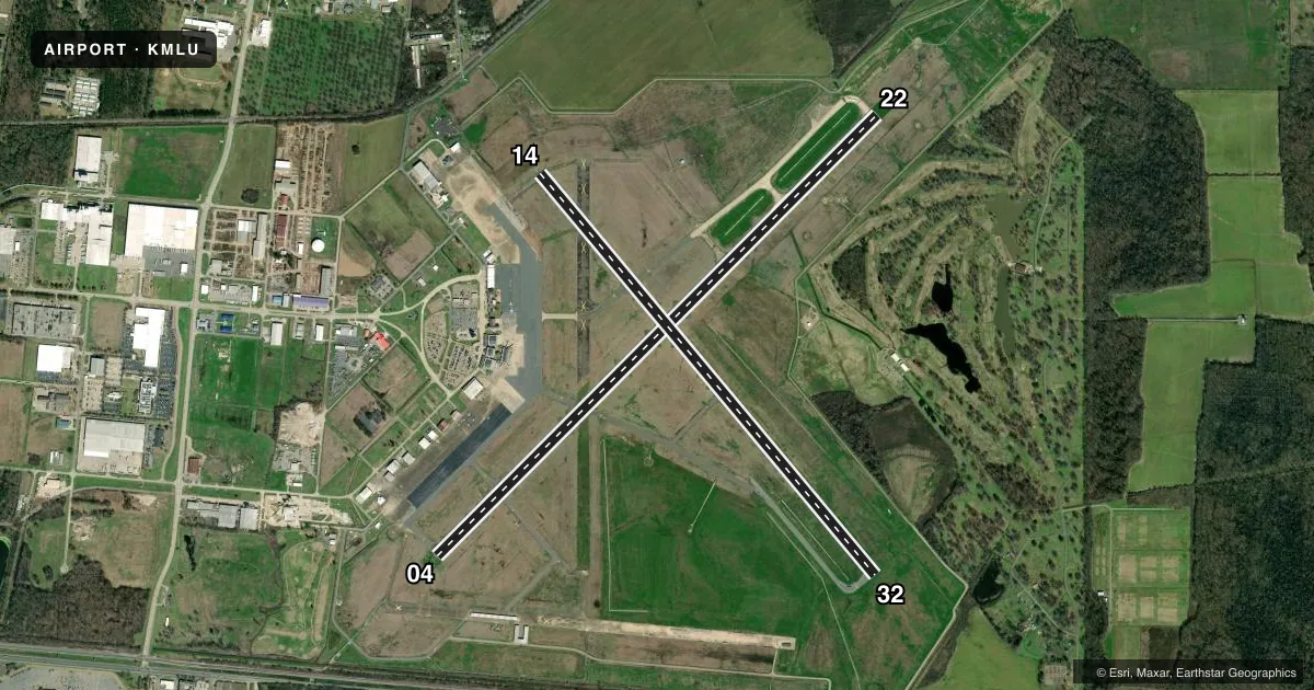
Runways & pattern
Full pagePattern entry · RWY 22
LEFT TRAFFIC| Runway | Heading (°M) | Length | Surface | Traffic |
|---|---|---|---|---|
| 04/22Favored | 42° / 222° | 7,504 ft | ASPH | Standard L |
| 14/32 | 137° / 317° | 6,301 ft | ASPH | Standard L |
Runway end performance
| End | TORA | TODA | ASDA | LDA | VGSI | Approach lights | Obstruction |
|---|---|---|---|---|---|---|---|
| 04 | 7,504' | 7,504' | 7,504' | 7,504' | PAPI 4-box left(3°) | MALSR | — |
| 22 | 7,504' | 7,504' | 7,504' | 7,504' | PAPI 4-box left(3°) | MALSR | — |
| 14 | 6,301' | 6,301' | 6,301' | 6,301' | PAPI 4-box left(3°) | — | — |
| 32 | 6,301' | 6,301' | 6,301' | 6,301' | PAPI 4-box left(3°) | — | — |
Declared distances in feet. TORA = takeoff run available, TODA = takeoff distance, ASDA = accelerate-stop, LDA = landing distance.
Airport sketch
Runways drawn to scale from FAA survey coordinates, rendered over satellite imagery. Not for navigation.
Approaches & charts
ILS · 2
Services on the field
Fuel grades, oxygen, maintenance, ramp storage and lighting — as declared to the FAA by the airport operator.
Fuel & services
- Fuel
- 100LLA
- Oxygen (bottled)
- Not available
- Oxygen (bulk)
- High pressure
- Airframe repair
- Major
- Power plant repair
- Major
- Other services
- AFRT,AMB,CARGO,CHTR,INSTR,RNTL,SALES
Ramp & ground
- Transient storage
- Tie-down
- Hangar
- Landing fee
- No fee published
- Customs
- Not available
- Lighting schedule
- SEE RMK
- Beacon schedule
- SS-SR
- Beacon
- White / Green (civil land)(WG)
- Wind indicator
- Lighted
- Segmented circle
- Yes
Fuel & FBOs
Cheapest 100LL and Jet A on the field and nearby. Always confirm with the FBO before taxi.
Airport notes
Surface conditions, obstructions, local procedures, lighting outages and other notes published with each FAA cycle.
General notes
- TWY E EAST OF RWY 04/22 RESTRICTED TO ACFT WITH WINGSPAN UNDER 90 FT. TWY C TURNAROUND BTN APCH END RWY 22 AND TWY C1 CLSD TO ACFT WINGSPAN MORE THAN 49 FT. TWY C2 CLSD.
- BIRD ACT ON AND INVOF ARPT.
- FOR CD WHEN ATCT IS CLSD CTC FORT WORTH ARTCC AT 817-858-7584
Lighting notes
- WHEN ATCT CLSD ACTVT MALSR RWYS 04 & 22; HIRL RWY 04/22; MIRL RWY 14/32; TWY LGTS - CTAF. PAPI RWYS 04, 22, 14 & 32 OPR CONSLY.
Runway surface & condition
- 04/22PCR VALUE: 1120/F/D/X/T
- 14/32PCR VALUE: 330/R/D/X/T
Other notes
- TWYS J & E EAST OF RWY 04/22 NOT AVBL FOR ACR OPNS WITH OVER 9 PSGR SEATS.
VFR map & nearby airports
VFR sectional. Tap any ICAO chip to open that airport.
Key facts · KMLU
Answer card- ICAO
- KMLU
- Name
- MONROE RGNL
- Location
- MONROE, LOUISIANA
- Elevation
- 78.9 ft MSL
- Traffic pattern altitude
- 1,078.9 ft MSL (1,000 AGL)
- Control tower
- Towered · 0600-2200
- Total runways
- 2
- Longest runway
- 04/22 · 7,504 ft
- Published ILS approaches
- 2
- Published frequencies
- 17
- Magnetic variation
- 3°
- Current flight rules
- VFR
- Current wind
- 260° at 6 kt
- Favored runway now
- RWY 22
Monroe Rgnl sits in Monroe, Louisiana. Field elevation is 78.9 ft MSL. The airport has 2 asphalt runways. The longest is runway 04/22 at 7,504 ft. Tower service is published from 0600 to 2200. When the tower is closed, use CTAF 118.9 and expect the published lighting to be available for the main runway. Two ILS approaches serve runway ends 04 and 22.
Pattern altitude is not published. Use 1,000 ft AGL for light piston traffic unless the current Chart Supplement says otherwise. Avflight Monroe is on the field. It carries 100LL, Jet A and Jet A Prist. Bird activity is noted on and near the airport. Keep a sharp scan on departure and arrival. Taxiway limits matter here too. Taxiway E east of runway 04/22 is restricted to aircraft with wingspan under 90 ft. Taxiway C turnaround between the approach end of runway 22 and taxiway C1 is closed to aircraft with wingspan more than 49 ft. Taxiways J and E east of runway 04/22 are not available for aircraft with more than 9 passenger seats. If you are planning a larger aircraft or a night arrival with the tower closed, verify the current Chart Supplement and coordinate with the airport operator or the FBO directly before you go.