METAR & TAF KMHK
Current METAR
Observed 19:52Z
KMHK 271952Z AUTO 20010KT 10SM CLR 37/23 A2976 RMK AO2 SLP064 T03720233
- Wind
- 200° @ 10 kt
- Visibility
- 10 SM
- Temp / Dew
- 37°C / 23°C
- Altimeter
- 29.76 inHg
- Clouds
- CLR
- Density alt
- 4,160 ft
- Ceiling
- Unlimited
- Rules
- VFR
Airport info & contacts
Manager on record, flight service, ARTCC, attendance schedule and pattern altitude — published by the FAA and refreshed every 28 days.
Location
- From city
- 4 NM SW
- VFR sectional
- KANSAS CITY
- Pattern altitude
- 843 ft AGL · 1,909 ft MSL
- ARTCC
- ZKC · KANSAS CITY
- NOTAM facility
- MHK (NOTAM-D)
Airport manager
- Name
- BRANDON KEAZER
- Phone
- 785-587-4565
- Address
- 5500 SKYWAY DRIVE, STE 120, MANHATTAN KS 66503-9791
Flight service · Hours
- FSS ICT
- WICHITA1-800-WX-BRIEF
- Attendance
- 0600-2200
Frequencies
Tap any row to copy the frequency to your clipboard.
Runways & pattern
Full pagePattern entry · RWY 21
LEFT TRAFFIC| Runway | Heading (°M) | Length | Surface | Traffic |
|---|---|---|---|---|
| 03/21Favored | 36° / 216° | 7,400 ft | CONC | 03 R |
| 13/31 | 138° / 318° | 5,001 ft | ASPH-CONC | 31 R |
Runway end performance
| End | TORA | TODA | ASDA | LDA | VGSI | Approach lights | Obstruction |
|---|---|---|---|---|---|---|---|
| 03 | 7,030' | 7,030' | 7,030' | 7,030' | PAPI 4-box left(3°) | MALSR | 105', trees, 3996' from thr, 537' R of cntrln, slope 36 |
| 21 | 7,400' | 7,400' | 7,400' | 7,030' | PAPI 4-box left(3°) | — | 86', trees, 2124' from thr, 259' R of cntrln, slope 23 |
| 13 | 5,000' | 5,000' | 5,000' | 5,000' | VASI 2-box left(3.5°) | — | 237', pole, 7174' from thr, 392' R of cntrln, slope 29 |
| 31 | 5,000' | 5,000' | 5,000' | 5,000' | PAPI 4-box left(3°) | — | 93', tree, 1607' from thr, 624' R of cntrln, slope 15 |
Declared distances in feet. TORA = takeoff run available, TODA = takeoff distance, ASDA = accelerate-stop, LDA = landing distance.
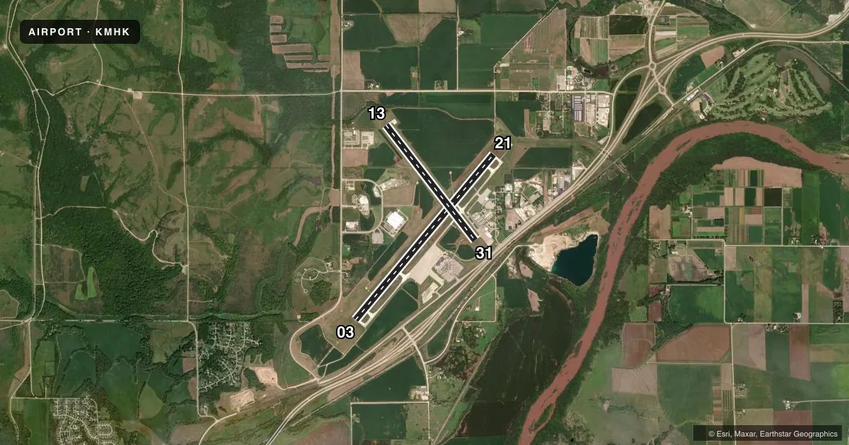
Airport sketch
Runways drawn to scale from FAA survey coordinates, rendered over satellite imagery. Not for navigation.
Approaches & charts
ILS · 1
Services on the field
Fuel grades, oxygen, maintenance, ramp storage and lighting — as declared to the FAA by the airport operator.
Fuel & services
- Fuel
- 100LLA
- Airframe repair
- Major
- Power plant repair
- Major
- Other services
- AMB,CARGO,CHTR,INSTR,RNTL,SALES,SURV
Ramp & ground
- Transient storage
- Tie-down
- Hangar
- Landing fee
- No fee published
- Customs
- Not available
- Lighting schedule
- SEE RMK
- Beacon schedule
- SS-SR
- Beacon
- White / Green (civil land)(WG)
- Wind indicator
- Lighted
- Segmented circle
- Yes
Fuel & FBOs
Cheapest 100LL and Jet A on the field and nearby. Always confirm with the FBO before taxi.
Airport notes
Surface conditions, obstructions, local procedures, lighting outages and other notes published with each FAA cycle.
General notes
- NONSTD ATC MINIMA APPLIED TO IFR HIGH PERFORMANCE OPS ARR WI CFNS OF R-3602.
- MIL ARPT 7 MI SW RESEMBLES THIS ARPT.
- BIRDS INVOF ARPT MAR-MAY & SEP-NOV; WILDLIFE ON & INVOF RWYS.
- 24 HR PPR FOR UNSKED ACR GTR THAN 30 PAX SEATS - 785-587-4597.
- FOR CD IF UNA CTC ON FSS FREQ, CTC MARSHALL APCH AS 785-239-2118. WHEN MARSHALL APCH IS CLSD, CTC KANSAS CITY ARTCC AT 913-254-8508.
Lighting notes
- WHEN ATCT CLSD ACTVT MALSR RWY 03; REIL RWY 21 & 31; HIRL RWY 03/21; MIRL RWY 13/31 - CTAF. PAPI RWY 03, 21 & 31; VASI RWY 13; OPR CONSLY.
Runway surface & condition
- 03/21PCR VALUE: 640/R/C/W/T
- 13/31PCR VALUE: 150/R/C/W/T
- 13/31RWY 13/31 NOT AVBL FOR PART 121/PART 380 OPS WITH SKED PAX CARRYING OPS MORE THAN 9 PAX SEATS AND NON-SKED PAX CARRYING OPS MORE THAN 30 PAX SEATS.
Other notes
- AFT HR ACR OPS NA 15 MIN BFR OR AFT SKED ARR OR DEP WO PPR TO CFM; ARFF SVC AVBL BFR LNDG OR TKOF - 785-587-4521.
- INDEX C EQUIP AVBL UPON REQ.
- TPA: LIGHT ACFT 843 AGL; TURBINE ACFT 1443 FT AGL.
- MULTICOM FREQ 122.85 AVBL.
- MANAGERAFT HR - 785-587-4562.
VFR map & nearby airports
VFR sectional. Tap any ICAO chip to open that airport.
Key facts · KMHK
Answer card- ICAO
- KMHK
- Name
- MANHATTAN RGNL
- Location
- MANHATTAN, KANSAS
- Elevation
- 1,066.1 ft MSL
- Traffic pattern altitude
- 1,909.1 ft MSL (843 AGL)
- Control tower
- Towered · 0600-2200
- Total runways
- 2
- Longest runway
- 03/21 · 7,400 ft
- Published ILS approaches
- 1
- Published frequencies
- 5
- Magnetic variation
- 4°
- Current flight rules
- VFR
- Current wind
- 200° at 10 kt
- Favored runway now
- RWY 21
Manhattan Rgnl sits in Manhattan, Kansas. Field elevation is 1,066.1 ft MSL. The airport has two runways. The longest is 7,400 ft. Tower service is available from 0600 to 2200. One ILS approach is published for runway 03. Pattern altitude is 843 ft AGL, which is 1,909.1 ft MSL.
On the field, Kansas Jet Center carries 100LL and Jet A. Heartland Aviation carries 100LL. If you are planning fuel or ramp time, call ahead. Published remarks also note multicom 122.85. That can help when the tower is closed. The field uses medium and high intensity lighting on the runway ends, with approach lighting and runway alignment indicators on runway 03. PAPI is available for runways 03, 21 and 31. VASI is available for runway 13.
This is a controlled airport with active traffic and military activity nearby. The remarks say a military airport 7 miles southwest resembles this field. Wildlife is also reported on and near the runways. Birds are noted in the area during spring and fall. For clearance delivery, use the published Marshall Approach contact if flight service is not available. If Marshall Approach is closed, use Kansas City Center. Check the current FAA Chart Supplement for any operational changes before you go.