METAR & TAF KMEZ
Current METAR
Observed 16:35Z
KMEZ 271635Z AUTO VRB06KT 10SM CLR 33/21 A2997 RMK AO2 T03280214
- Wind
- VAR @ 6 kt
- Visibility
- 10 SM
- Temp / Dew
- 33°C / 21°C
- Altimeter
- 29.97 inHg
- Clouds
- CLR
- Density alt
- 3,437 ft
- Ceiling
- Unlimited
- Rules
- VFR
Airport info & contacts
Manager on record, flight service, ARTCC, attendance schedule and pattern altitude — published by the FAA and refreshed every 28 days.
Location
- From city
- 2 NM SE
- VFR sectional
- MEMPHIS
- ARTCC
- ZME · MEMPHIS
- NOTAM facility
- MEZ (NOTAM-D)
Airport manager
- Name
- FRED OGDEN
- Phone
- 479-394-4077
- Address
- 520 MENA ST, MENA AR 71953
Flight service · Hours
- FSS JBR
- JONESBORO1-800-WX-BRIEF
- Attendance
- DAWN-DUSK
Frequencies
Tap any row to copy the frequency to your clipboard.
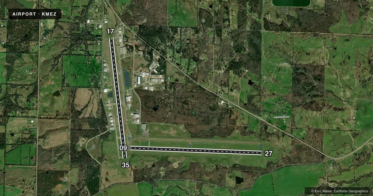
Runways & pattern
Full pagePattern entry · RWY 35
LEFT TRAFFIC| Runway | Heading (°M) | Length | Surface | Traffic |
|---|---|---|---|---|
| 09/27 | 89° / 269° | 5,485 ft | ASPH | Standard L |
| 17/35Favored | 170° / 350° | 5,001 ft | ASPH | Standard L |
Runway end performance
| End | TORA | TODA | ASDA | LDA | VGSI | Approach lights | Obstruction |
|---|---|---|---|---|---|---|---|
| 09 | — | — | — | — | PAPI 4-box left(3.5°) | — | — |
| 27 | — | — | — | — | PAPI 4-box left(3°) | — | — |
| 17 | — | — | — | — | PAPI 4-box left(3°) | — | 20', tree, 800' from thr, 55' R of cntrln, slope 30 |
| 35 | — | — | — | — | — | — | 40', tree, 1200' from thr, 450' R of cntrln, slope 25 |
Declared distances in feet. TORA = takeoff run available, TODA = takeoff distance, ASDA = accelerate-stop, LDA = landing distance.
Airport sketch
Runways drawn to scale from FAA survey coordinates, rendered over satellite imagery. Not for navigation.
Approaches & charts
ILS · 1
Services on the field
Fuel grades, oxygen, maintenance, ramp storage and lighting — as declared to the FAA by the airport operator.
Fuel & services
- Fuel
- 100LLA
- Oxygen (bottled)
- Low pressure
- Oxygen (bulk)
- Not available
- Airframe repair
- Major
- Power plant repair
- Major
- Other services
- INSTR,RNTL,SALES
Ramp & ground
- Transient storage
- Tie-down
- Hangar
- Landing fee
- No fee published
- Customs
- Not available
- Lighting schedule
- SEE RMK
- Beacon schedule
- SS-SR
- Beacon
- White / Green (civil land)(WG)
- Wind indicator
- Lighted
- Segmented circle
- Yes
Fuel & FBOs
Cheapest 100LL and Jet A on the field and nearby. Always confirm with the FBO before taxi.
Airport notes
Surface conditions, obstructions, local procedures, lighting outages and other notes published with each FAA cycle.
General notes
- MOUNTAINS NORTH AND SOUTH SOUTHWEST OF ARPT.
- MIGRATORY BIRDS & DEER ON & INVOF ARPT.
- FOR CD CTC MEMPHIS ARTCC AT 901-368-8453/8449.
Lighting notes
- MIRL RWY 09/27 OPR SS-SR. ACTVT PAPI RWYS 09, 27, & 17; MIRL RWY 17/35 - CTAF.
Approach & departure obstructions
- 09PAPI RWY 9 UNUSBL BYD 7 DEG RIGHT OF CNTRLN.
- 091675 FT MT 13000 FT WEST OF RWY THR.
Other notes
- AS PER ALP
- OWNERAFTER HOURS PLEASE CALL 479-394-4077
VFR map & nearby airports
VFR sectional. Tap any ICAO chip to open that airport.
Key facts · KMEZ
Answer card- ICAO
- KMEZ
- Name
- MENA INTERMOUNTAIN MUNI
- Location
- MENA, ARKANSAS
- Elevation
- 1,079.9 ft MSL
- Traffic pattern altitude
- 2,079.9 ft MSL (1,000 AGL)
- Control tower
- Non-towered (use CTAF)
- Total runways
- 2
- Longest runway
- 09/27 · 5,485 ft
- Published ILS approaches
- 1
- Published frequencies
- 2
- Magnetic variation
- 3°
- Current flight rules
- VFR
- Current wind
- 000° at 6 kt
- Favored runway now
- RWY 35
Mena Intermountain Muni sits in Mena, Arkansas. Field elevation is 1,079.9 ft MSL. The airport has two asphalt runways. The longest is runway 09/27 at 5,485 ft. There is one ILS approach. It serves runway 27.
This is an uncontrolled field. CTAF and UNICOM are both 122.8. Pattern altitude is not published, so use the standard 1,000 ft AGL for light piston operations unless the current Chart Supplement says otherwise. Mena Air Center is on the field. It carries 100LL, Jet A and Jet A Prist. Call the FBO directly at (479) 394-5800 for current service details. After hours, the airport remarks say to call 479-394-4077.
Plan for terrain. Mountains are north and south southwest of the airport. There is also a 1,675 ft mountain about 13,000 ft west of the runway 09 threshold. Wildlife is part of the picture here too. Migratory birds and deer are reported on and near the airport. Runway 09/27 has medium intensity lights from sunset to sunrise. The PAPI on 09, 27 and 17 is keyed to CTAF. The PAPI for runway 9 is unusable beyond 7 degrees right of centerline. If you need clearance delivery, contact Memphis Center before departure.